Kentucky Weekly Weather Summary
Kentucky Climate Summary
For the Period November 8, 2021 to November 14, 2021

Slightly Above Normal Temperatures and Below Normal Rainfall:

The period started with dry conditions in place, but much milder temperatures compared to the previous week. Highs consistently jumped
into the upper 60s to low 70s early in the week under mostly sunny skies and southerly winds. Big changes arrived on Thursday with the
passage of a strong cold front. This boundary produced a widespread band of showers, which accounted for most of the 0.58-inch state
average for the week. Additional rounds followed over the weekend, but were fairly light in nature. Saying that, cooler temperatures
did lead to precipitation type changing for the first time this fall with some reporting light snow and/or sleet. In addition, gusty
winds were common with the passage of the cold front on Thursday and days following. Many locations saw gusts exceed 30 mph and some
even topping 40 at times.

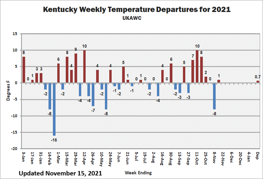
Temperatures for the period averaged 50 degrees across the state which was 1 degree warmer than normal and 8 degrees warmer than the
previous period. High temperatures averaged from 61 in the West to 63 in the East. Departure from normal high temperatures ranged from
near normal in the West to 2 degrees warmer than normal in the East. Low temperatures averaged from 39 degrees in the West to 37
degrees in the East. Departure from normal low temperature ranged from 1 degree cooler than normal in the West to 1 degree warmer than
normal in the East. The extreme high temperature for the period was 76 degrees at PEABODY and the extreme low was 24 degrees at BENTON
4N.

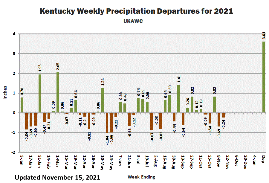
Precipitation (liq. equ.) for the period totaled 0.58 inches statewide which was 0.24 inches below normal and 71% of normal.
Precipitation totals by climate division, West 0.47 inches, Central 0.66 inches, Bluegrass 0.71 inches and East 0.50 inches, which was
-0.51, -0.20, 0.00 and -0.24 inches respectively from normal. By station, precipitation totals ranged from a low of 0.25 inches at
JACKSON AIRPORT to a high of 1.04 inches at BURLINGTON 4S.

