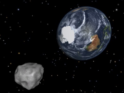
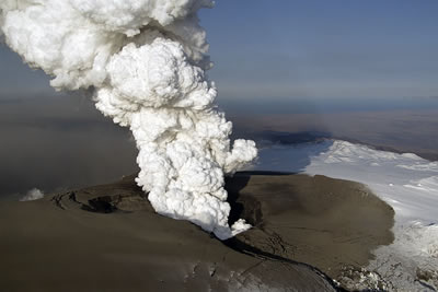
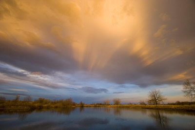
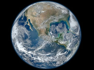
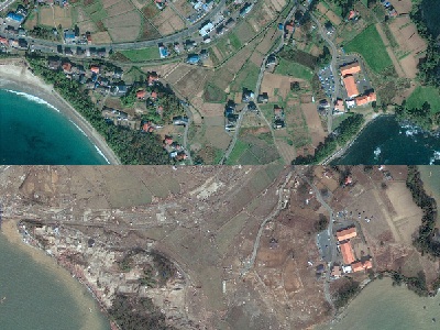
A near-Earth <a href="/our_solar_system/asteroids.html">asteroid</a> - named 2012 DA14 by astronomers - passed within 17,200 miles from Earth on February 15, 2013. On closest approach at about 1:25 p.m. CST on February 15, although it was within the orbit of the <a href="/earth/moons_and_rings.html">Moon</a> and even geosynchronous <a href="/space_missions/satellites.html">satellites</a>, it didn't strike Earth!  Find out more from <a href="http://www.nasa.gov/mission_pages/asteroids/news/asteroid20130201315144.html">NASA</a>! Fragments of a meteorite hit Chelyabinsk, Russia on 2/15/2013 <a href="http://www.reuters.com/article/2013/02/15/us-russia-meteorite-idUSBRE91E05Z20130215">injuring over 500</a>. Learn about <a href="http://www.windows2universe.org/our_solar_system/meteors/meteors.html">meteors and meteorites</a>.<p><small><em>NASA/JPL-CalTech</em></small></p>A <a href="http://iopscience.iop.org/1748-9326/8/2/024035/article">study</a> of over 40,000 written entries in Irish Annals and ice core measurements shows a strong correlation between <a href="http://www.windows2universe.org/earth/interior/eruptions.html">volcanic eruptions</a> and extreme cold weather in Ireland over a 1200 year period, from 431 to 1649.  During this time up to 48 volcanic eruptions were identified in Greenland ice core records through deposition of volcanic sulfate in annual layers of ice. Find out more about <a href="http://www.windows2universe.org/earth/climate/geosphere_volcanoes_influence_on_climate.html">volcanoes and climate</a>.<p><small><em>Image Courtesy of Marco Fulle</em></small></p>Anti-crepuscular rays are beams of sunlight that appear to converge on a point opposite the sun. They are similar to crepuscular rays, but are seen opposite the sun in the sky. Anti-crepuscular rays are most frequently visible near sunrise or sunset. This photo of anti-crepuscular rays was taken at sunset in Boulder, Colorado. Crepuscular rays are usually much brighter than anti-crepuscular rays.<p><small><em> Image Courtesy of Carlye Calvin</em></small></p>This image is a montage of high resolutions photographs of the Earth taken in January 2012 by the Visible/Infrared Imager Radiometer Suite (VIIRS) instrument on the Suomi NPP satellite.  The image shows many stunning details of <a href="http://www.windows2universe.org/earth/earth.html">our home planet</a> - <a href="http://solarsystem.nasa.gov/multimedia/gallery/VIIRS_4Jan2012.jpg">particularly at high resolution</a>. The beauty of our planet is obvious from space - our blue <a href="http://www.windows2universe.org/earth/Water/overview.html">waters</a>, our white <a href="http://www.windows2universe.org/earth/Atmosphere/cloud.html">clouds</a>, and the green from <a href="http://www.windows2universe.org/earth/Life/life.html">life</a> abundant at the surface.<p><small><em>Image courtesy of NASA</em></small></p>This first global map of <a href="http://www.windows2universe.org/earth/Water/ocean.html">ocean</a> surface saltiness, released in September 2012 by the NASA Aquarius mission team, shows the distribution of salt in the first 2 cm of the Earth's ocean. <a href="http://www.windows2universe.org/earth/Water/salinity.html">Salinity</a> variations are one of the main drivers of <a href="http://www.windows2universe.org/earth/Water/circulation1.html">ocean circulation</a>, and are closely connected with the <a href="http://www.windows2universe.org/earth/Water/water_cycle.html">cycling of freshwater</a> around the planet. High salinity is seen in the Mediterranean, Atlantic, and the Arabian Sea.<p><small><em>Image courtesy of NASA/GSFC/JPL-Caltech</em></small></p>March 2012 marks the first anniversary of the 9.0 magnitude <a href="/earth/geology/quake_1.html">earthquake</a>, <a href="/earth/tsunami1.html">tsunami</a>, and resulting nuclear accident in Japan on <a href="/headline_universe/march112011earthquaketsunami.html">11 March 2011</a>.  The tsunami did massive damage, wiping out entire villages and killing ~16,000 people, and leading to one of the most serious nuclear accidents in history.  This image shows before and after photos of the area north of Sendai, where 10,000 people were lost.<p><small><em>Photos by <a href="http://www.nytimes.com/interactive/2011/03/13/world/asia/satellite-photos-japan-before-and-after-tsunami.html?hp">GeoEye/EyeQ</a>.</em></small></p>

Windows to the Universe, a project of the National Earth Science Teachers Association, is sponsored in part is sponsored in part through grants from federal agencies (NASA and NOAA), and partnerships with affiliated organizations, including the American Geophysical Union, the Howard Hughes Medical Institute, the Earth System Information Partnership, the American Meteorological Society, the National Center for Science Education, and TERC. The American Geophysical Union and the American Geosciences Institute are Windows to the Universe Founding Partners. NESTA welcomes new Institutional Affiliates in support of our ongoing programs, as well as collaborations on new projects. Contact NESTA for more information. NASA ESIP NCSE HHMI AGU AGI AMS NOAA
pFad - Phonifier reborn

Pfad - The Proxy pFad of © 2024 Garber Painting. All rights reserved.

Note: This service is not intended for secure transactions such as banking, social media, email, or purchasing. Use at your own risk. We assume no liability whatsoever for broken pages.


Alternative Proxies:

Alternative Proxy

pFad Proxy

pFad v3 Proxy

pFad v4 Proxy