Forecast for Central Texas
Reports from LCRA’s Hydromet
Rainfall summaryTemperature summary
Humidity summary
Bob's Blog on Central Texas Weather
A Wet Weather Pattern Developing this Weekend, Continuing through Late Next Week
Weather Highlights
- Light to moderate rain showers are forecast to develop Saturday night and continue into Sunday in advance of a cold front
- Totals are forecast to generally average between 0.25 and 0.5 inches for areas east of Interstate 35. Amounts across the Hill Country should only average around a tenth of an inch
- More widespread and heavier rain is forecast next Wednesday and Thursday when a large trough of low pressure slowly moves across Texas
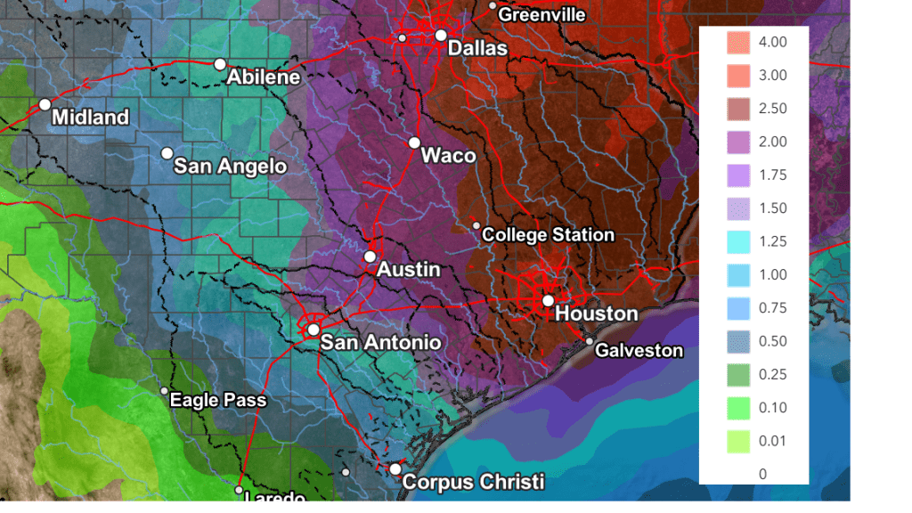
- Totals late next week are forecast to generally average between 1 and 2 inches across the Hill Country, and between 2 and 3 inches across Central Texas and the middle Texas coast. Some isolated higher totals will be possible
Discussion
Winter definitely made its presence known this week, with the wintery precipitation and very cold temperatures. Although sunshine returned Wednesday and Thursday, the arctic air has been slow to move out. Friday morning saw another hard freeze across much of the area. According to LCRA’s Hydromet, low temperatures Friday morning were generally between 15 and 20 degrees across the Hill Country, in the upper teens to low 20s across Central Texas, and in the mid-20s to low 30s across the coastal plains region. There were a couple of gauges located in Schleicher and Sutton Counties, to the west of Junction, that recorded a low temperature of 9 degrees!
The artic air will finally begin pushing off to the east Friday afternoon and Friday night as southwesterly breezes develop, pulling milder air into Texas. This appears to be the start of a milder weather pattern that will continue over the weekend and next week. While one last light freeze is forecast Friday night, no additional hard freezes or additional arctic air is expected through late next week. With the arctic air moving out, attention will be turning to the potential for rain this weekend and late next week.
Sunny weather will be in place Friday as a weak ridge of high pressure slides over Texas. The sky looks to remain clear Friday night.
- High temperatures Friday are predicted to be in the mid and upper 50s
- Low temperatures Saturday morning will include the low and mid-30s across the Hill Country and Central Texas, with mid and upper 30s towards the coast
- High temperatures Saturday are forecast to be upper 50s to low 60s
Widespread low clouds and moisture are forecast to spread north from the Gulf of Mexico beginning Saturday morning in response to a vigorous trough of low pressure that will be pushing south along the coast of California. Saturday’s sky is forecast to remain mostly cloudy. Scattered light rain showers are predicted to develop across the area Saturday evening as the lower atmosphere continues to moisten ahead of a weak Canadian cold front pushing south out of North Texas. Widespread light to moderate rain showers and even a couple of isolated thunderstorms are forecast to develop after midnight Saturday night, continuing into Sunday morning. The rain is forecast to taper off from north to south Sunday morning across the Hill Country and Central Texas regions Sunday morning as the cold front pushes to the south. Rain showers will likely continue across the coastal plains region through Sunday afternoon and evening as the front slowly moves off the coast.
The highest totals of rain Saturday through Sunday are forecast to occur to the east of Interstate 35, where widespread totals of 0.25 to 0.5 inches are forecast. Some isolated totals to near 1 inch will be possible. Across the Hill Country, most totals should average less than a tenth of an inch.
NWS Rainfall Forecast for the Period 6 am Saturday through 6 am Monday:

- Low temperatures Sunday morning are forecast to be in the mid and upper 40s across the Hill Country and Central Texas regions, and in the mid-50s across the coastal plains
- High temperatures Sunday are predicted to be in the low 50s across the Hill Country and Central Texas regions, mid to upper 60s towards the coast.
For next week, Monday and Tuesday are forecast to be mostly cloudy and generally dry. An isolated light rain shower or two cannot be ruled out for Tuesday, but no significant rain is expected. Our region will be under the influence of a southwesterly wind flow in the middle and upper atmosphere that will be pulling clouds and moisture across Texas out of the Pacific and Gulf of Mexico.
- High temperatures Monday and Tuesday are forecast to be in the upper 50s low 60s
- Low temperatures Tuesday morning are forecast to be in the upper 40s
- Low temperatures Wednesday morning will be in the mid and upper 50s
The chance for rain and thunderstorms will increase dramatically across the region Wednesday through Thursday night when a large trough of low pressure slowly pushes east towards Texas out of the Great Basin. Ahead of the trough, considerable moisture will be drawn north, creating a moist and moderately unstable atmosphere. Waves of low pressure moving over the area out ahead of the main trough are expected to cause the development of showers and thunderstorms beginning late Tuesday night and early Wednesday morning. Periods of rain showers and scattered thunderstorms are forecast to continue Wednesday afternoon and Wednesday night. Showers and scattered thunderstorms are expected to become heavier and more widespread Thursday into Thursday night as the main upper trough moves across Texas. Depending on how the situation sets up, areas east of Interstate 35 could see the development of heavy rain on Thursday. Pockets of locally heavy rain will be possible across the rest of the region as well. The rainy period is forecast to diminish Thursday night into Friday morning as the upper trough lifts up to the northeast.
Looking at rain totals from this system, significant amounts will be possible. Totals between Wednesday evening through Friday morning are forecast to generally average between 1 and 2 inches across the Hill Country, and between 2 and 3 inches across Central Texas and the middle Texas coast. Parts of the coastal region could see totals as high as four inches. There is still quite a bit of uncertainty in the forecast, but conditions are looking quite wet late next week.
NWS Rainfall Forecast for the Period 6 pm Wednesday through 6 pm Friday:
 High temperatures late week into next weekend are expected to be mild, with highs in the 60s to low 70s. Lows are forecast to be in the 40s.
Have a great weekend!
Bob
Arctic Outbreak Tuesday Update
Weather Highlights
- The wintery precipitation has ended and pushed well off to the east
- All winter weather warnings and advisories have been canceled
- A Cold Weather Advisory has been posted Tuesday night until noon Wednesday for forecasted temperatures to dip into the teens and low 20s
- Sunny and slightly warmer weather is forecast Wednesday through Friday, although hard freezes still look to occur Thursday and Friday mornings
Discussion
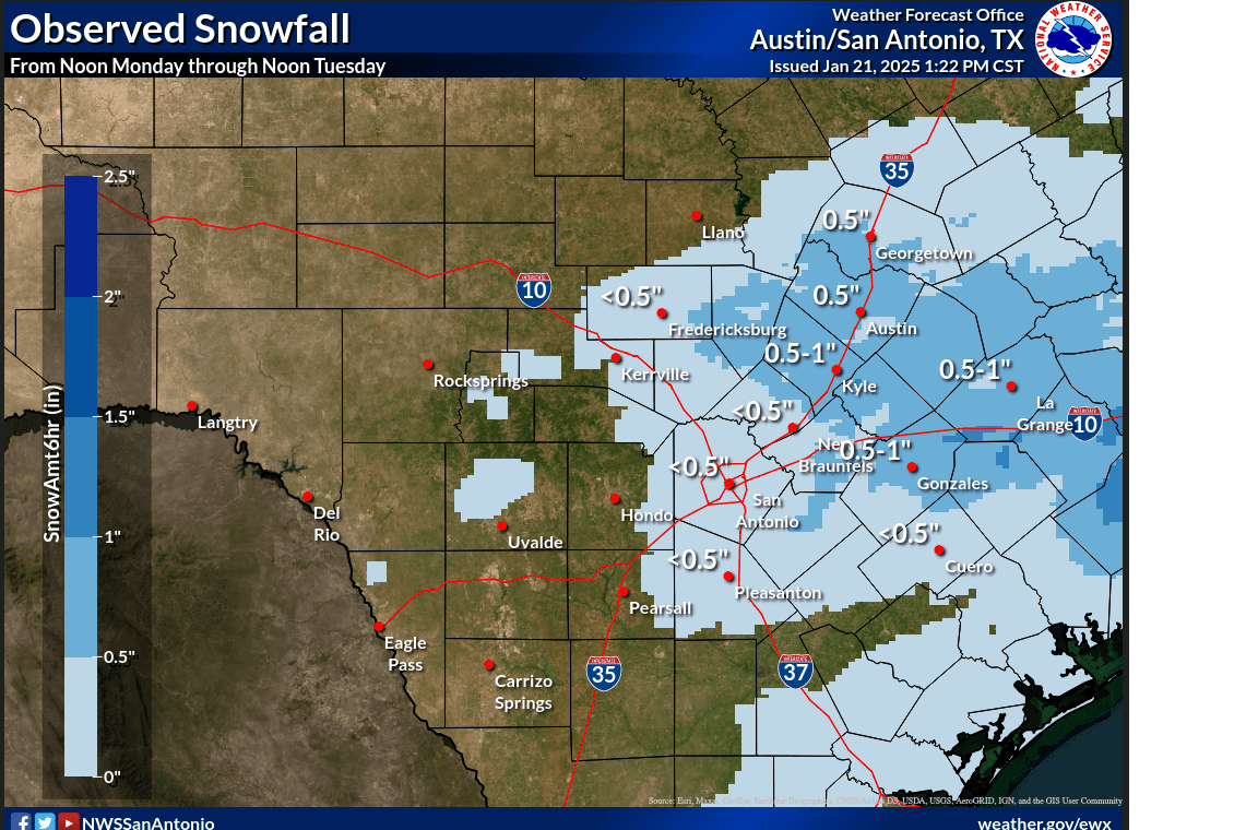
The wintery precipitation which developed across the area Monday has ended and moved well off to the east. All winter weather warnings and advisories have now been canceled. Precipitation overnight generally ranged from a dusting of snow across the eastern Hill Country, to between 0.5 and 1 inches across the Austin/Interstate 35 corridor, to between 1 and 2 inches from the Gonzales/La Grange area, southeastward to the middle Texas coast.
A Rough Idea of Observed Snowfall Totals Courtesy of the National Weather Service:
Clouds are clearing across the region in the wake of the departing storm system. This afternoon’s sunshine and breezy weather is helping to melt/evaporate much of the leftover precipitation on area roads and bridges. No major travel concerns are expected across the area Wednesday morning. However, some shaded/protected areas (such as those under overpasses) may still hold onto a little ice into Wednesday morning.
A clear sky is forecast Tuesday night. Winds should decrease to around 5-10 mph overnight which will allow temperatures to become quite cold. The National Weather Service has posted a Cold Weather Advisory for the entire region through noon Wednesday.
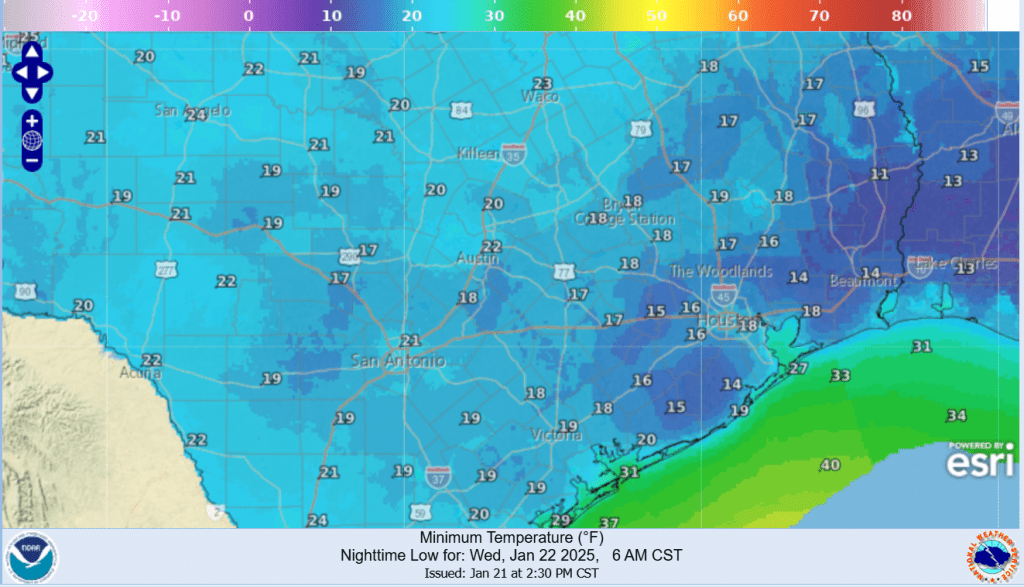
- Lows Wednesday morning are forecast to generally be in the upper teens to 20 degrees across the Hill Country and Central Texas regions, and between 15 and 20 degrees for areas south of Interstate 10
Forecasted Low Temperatures Wednesday Morning:
Sunny and dry weather will be in place Wednesday through Friday. Forecasts call for a weak cold front to push across the area Thursday morning that will reinforce the cool temperatures already in place. Daytime temperatures will trend a little milder, while nighttime readings will still remain quite cold. Hard freezes can be expected Wednesday and Thursday nights.
- Low temperatures Thursday and Friday mornings will generally be in the mid and upper 20s
- Lows Saturday morning are forecast to be in the low and mid-30s
- High temperatures Wednesday will range from upper 40s across the coastal plains, to the mid-50s across the Hill Country
- High temperatures Thursday will generally be around 50 degrees
- High temperatures Friday are forecast to be in the low and mid-50s
Looking ahead to the upcoming weekend, forecasts call for a return of southerly breezes and milder temperatures. Expect high temperatures to be in the upper 50s and low 60s. A couple of waves of low pressure tracking northeast out of Mexico will cause a chance for scattered rain showers and isolated thunderstorms for areas along and east of Interstate 35 Saturday night through Sunday night. Rain amounts are forecast to generally average below a quarter inch. There are indications this cloudy, wet pattern may extend into the first half of next week as well.
Have a great week!
Bob
Arctic Outbreak Monday Update
Weather Highlights
- Precipitation is predicted to develop and spread north across the region Monday evening into early Tuesday
- A mix of rain, freezing rain, sleet, and snow is forecast Monday evening
- Most of the precipitation should transition to snow after midnight Monday night
- The most likely snow and sleet accumulations are expected to range from less than a half inch across the eastern Hill Country, to around 1 inch across Austin and Central Texas area, to between 1 and 3 inches for areas south of Interstate 10
- Ice accumulations are forecast to only be around a trace in the Austin area. To the southeast of Austin, ice accumulations are forecast to range between 0.01 inch and 0.1 inch
- All of the precipitation should come to an end by mid-morning Tuesday
- Very cold temperatures are forecast Tuesday night. Readings could reach 15 degrees Wednesday morning over the area between La Grange and Wharton due to lingering snow cover
- Dry and milder will develop Thursday and continue into the weekend
…A winter storm warning will be in effect for the Austin/Interstate 35 corridor and areas southeast to the coast from 6 pm Monday through 6 pm Tuesday…
…A Winter Weather Advisory will be in effect for the eastern Hill Country from 6 pm Monday through 6 pm Tuesday…
Discussion
Clouds spread north across the area sooner than expected Monday and have kept temperatures from warming significantly. Monday’s clouds are the result of a trough of a trough of low pressure advancing southeast out of the Desert Southwest. Monday’s forecasts are calling for the system to move in and depart a little faster than previously expected.
With the trough of low pressure moving a bit faster than previously expected and with forecasts showing somewhat less moisture available, precipitation predictions have come down slightly. Nevertheless, high resolution forecasts show a very messy winter weather event unfolding Monday evening, continuing through the overnight hours. Light precipitation is forecast to develop across the coastal Plains early Monday evening as the overrunning pattern initiates. The precipitation is predicted to expand north into Central Texas and the eastern Hill Country late evening and toward midnight.
- For areas south of Interstate 10, the precipitation is forecast to start off as a mixture of freezing rain and sleet Monday evening, with the precipitation becoming sleet and snow showers after midnight.
- Across Central Texas, a mixture of light rain, sleet, and snow showers is forecast Monday evening, with the precipitation becoming mostly snow showers after midnight
- Across the eastern Hill Country, light snow showers are forecast to develop Monday evening and continue overnight.
The precipitation is forecast to end from west to east beginning around daybreak Tuesday.
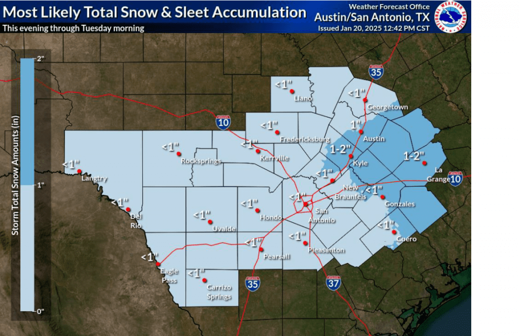
Total snow/sleet and ice accumulations are forecast to total around a half inch across the Hill Country. For most of Central Texas, accumulations are forecast to average around 1 inch, with some totals up to 2 inches in the area between Bastrop and La Grange. For areas south of Interstate 10, accumulations of 1-3 inches are forecast.
Total ice accumulations are predicted to be around a trace across the eastern Hill Country and around 0.01 inch across the Austin/Interstate 35 corridor. Ice accumulations are forecast to be between 0.01 and 0.1 inches over the area stretching between La Grange and Matagorda.
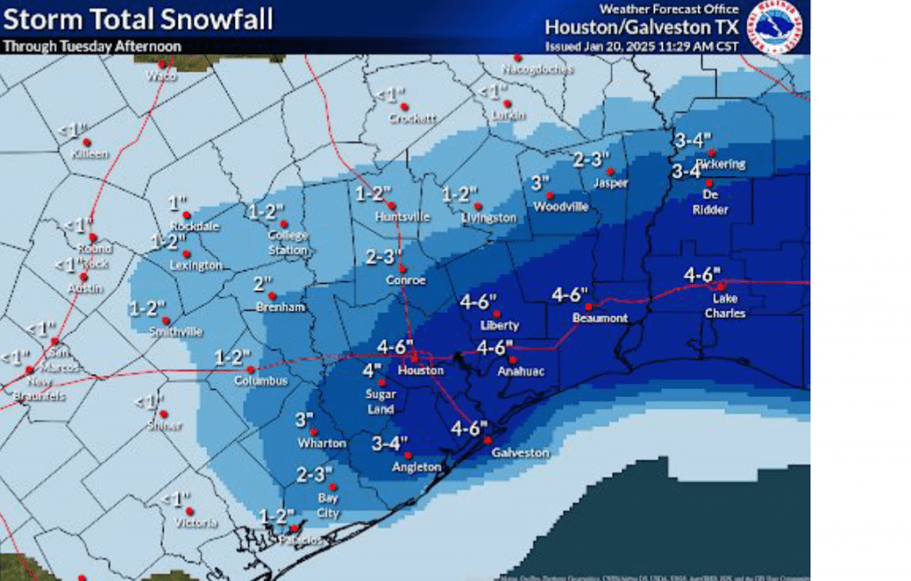
Travel may become hazardous and difficult Monday night through midday Tuesday. Travel impacts may return Tuesday night into Wednesday morning as any remaining moisture on roads refreezes.
Clouds are forecast to decrease and the sky become mostly sunny Tuesday afternoon. Despite the sun, temperatures will stay cold, with highs in the mid and upper 30s. Expect a northerly wind at 10-15 mph, with gusts to 30 mph.
Clear and very cold temperatures are predicted for Tuesday night into Wednesday morning as the sky clears and winds diminish. Low temperatures Wednesday morning are forecast to generally be between 18 and 20 degrees across the Hill Country and Central Texas. Interestingly, some of the coldest readings down to near 15 or 16 degrees are predicted to occur across the coastal plains region, where considerable frozen precipitation will likely still be on the ground.
Minimum Temperatures Forecast Wednesday Morning:

Sunny and milder weather will develop Wednesday afternoon with highs in the 40s. Sunny and dry weather continue Thursday through Friday. Lows Thursday morning will generally be in the mid-20s. Highs Thursday are forecast to be in the upper 40s to low 50s, warming to the upper 50s on Friday.
Bob
Sunday Arctic Outbreak Update
…A Winter Storm Warning has been posted for areas along and east of Interstate 35, including the Austin metro area and the coastal plains, from 6 pm Monday through 6 pm Tuesday…
…A Winter Weather Advisory has been posted for the eastern Hill Country from 6 pm Monday through 6 pm Tuesday…
…Accumulating snow, sleet, and ice will make travel difficult and inadvisable within the warning area Monday night through Wednesday morning…
Weather Highlights
- Confidence has increased for the development of accumulating snow, sleet and ice for areas along and east of Interstate 35 Monday night through midday Tuesday
- Forecasts call for snow and ice accumulations through Tuesday afternoon of 1-2 inches for areas along the I-35 corridor (including the Austin metro). Accumulations to near 3 inches are forecast for Layette and Lee Counties. Accumulations of 3-5 inches are forecast for the coastal plains
- The snow and ice is expected to make travel hazardous and inadvisable Monday night through midday Wednesday
- Very cold temperatures will continue through Wednesday night. Readings Tuesday night look to be the coldest of the week, with lows Wednesday morning dipping into the upper teens at most locations
Discussion
The focus of today’s report will be on the increased threat for wintery precipitation across the region from Monday night till about midday Tuesday. Before I get into that, I did want recap the latest low temperature forecast. Readings Tuesday night into Wednesday morning are now expected to be a bit colder than previously predicted. Do note Tuesday’s high temperatures are forecast to only be in the low and mid-30s.
Low Temperatures Forecast this Week:
- Monday morning: Upper teens to 20 degrees across the Hill Country, 20-22 degrees across Central Texas, mid 20s coastal plains
- Tuesday morning: Low 20s Hill Country and Central Texas, and mid-20s coastal plains
- Wednesday morning: Between 15 and 18 degrees across the Hill Country, Central Texas and coastal regions
- Thursday morning: Mid-20s across the entire region
After a very cold and clear start to Martin Luther King Jr. day, clouds are forecast to quickly increase from south to north beginning around midday Monday in response to a trough of low pressure tracking southeast out of northwest Texas. Sunday’s suite of forecast solutions are now in good agreement this system will begin to pull moisture northwest from the Gulf of Mexico, creating an overrunning pattern of clouds and precipitation. The moisture is forecast to be most abundant across the coastal plains, where the precipitation will likely be the heaviest. Forecasts call the precipitation to set up in training bands, which will have the potential to produce high totals of rain, sleet, and snow. Lower amounts of precipitation are forecast further inland where the moisture will be less plentiful.
Light mixed precipitation, mainly in the form of light rain and sleet is forecast to develop across the region sometime Monday evening. The precipitation is expected to increase in coverage and intensity throughout the evening and toward midnight. Across the Hill Country and Central Texas regions, the precipitation is predicted to transition to mainly snow showers with some occasional sleet around midnight and continue into Tuesday morning. The precipitation is forecast to taper off from west to east late Tuesday morning as the upper trough exits to the east. For areas south of Interstate 10, a mixture of rain, freezing rain, and sleet is forecast after midnight Monday night. A mixture of mainly snow showers and sleet is forecast from daybreak Tuesday till about midday. Dry weather is forecast beginning Tuesday afternoon as the upper trough exits to the northeast.
Snow and Sleet Accumulations
- For the eastern Hill Country, extending north to San Saba, snow and sleet totals are forecast to generally average less than 1 inch. Ice accumulations are forecast to be close to 0.01 inch.
- For the Austin and Central Texas region: Snow and sleet totals of 1-2 inches are forecast. Lee and Fayette Counties could see snow totals up to 3 inches. Sleet/Ice totals are forecast to average around 0.01 inches.
- For the Middle Texas Coast: Snow totals of 3-5 inches are forecast. Isolated higher totals will be possible. Ice accumulation up to a tenth of an inch will be possible

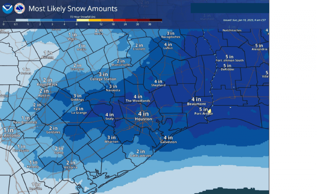
Travel across the area is expected to become difficult and inadvisable, especially across elevated bridges and overpasses, as roads become slick and hazardous beginning Monday night and continuing into Tuesday. Due to the very cold temperatures Tuesday afternoon, most of the snow and sleet on the ground won’t have a chance to melt Tuesday afternoon. Therefore, hazardous travel conditions will likely extend into Wednesday morning. Temperatures are forecast to warm into the mid-40s Wednesday afternoon, which should help to melt most of the snow and ice.
Partly cloudy and milder weather is predicted beginning Thursday as the arctic air finally moves off to the east. High temperatures in the mid and upper 60s are forecast next weekend.
Bob
Saturday Update on the Arctic Air and the Threat for Wintery Precipitation
Here’s an update on the arctic air that will begin spreading into our region Saturday night and the threat for wintery precipitation early next week. Confidence has increased in the development of wintery precipitation across Central Texas and the middle Texas coast Monday night into Tuesday. In addition, the temperature forecast for Tuesday night has trended slightly colder.
Weather Highlights:
- Very cold air will arrive Saturday evening and remain across the area through next Thursday
- Windy conditions will develop Saturday evening and persist into Tuesday. Expect gusts to near 30 mph.
- Low temperatures Wednesday morning are forecast to be in the mid and upper teens across the Hill Country and close to 20 degrees at most other locations
- Confidence in the development of wintery precipitation across Central Texas and the middle Texas Monday night into midday Tuesday has increased to between 60 and 70 percent.
- A Winter Storm Watch has been posted for areas along and south of Interstate 10 Monday evening through Tuesday afternoon
Discussion
The much anticipated outbreak of arctic air will begin to be felt Saturday night when much colder air spreads into the region behind an arctic cold front. The arctic cold is forecast to remain in place through Wednesday and will bring our region several periods of hard freezes. Northerly winds will increase to a range of 10-15 mph, with occasional gusts to 30/35 mph Saturday night, with continued breezy conditions expected to continue into Tuesday. The combination of the strong winds and the very cold air will produce wind chill temperatures into the teens Sunday, Monday, and Tuesday mornings. Due to these very chilly temperatures, the National Weather Service has posted a Cold Weather Advisory for the region from midnight Saturday night till 9 am Saturday. The advisory will likely be extended into next week.
Sunny, dry and cold weather is forecast Sunday. The sky looks to become cloudy Monday afternoon and remain cloudy through Tuesday afternoon. Clouds should clear Tuesday night, followed by a mostly sunny sky next Wednesday through Friday.
An update on low temperatures forecast through late next week:
- Sunday morning: Low and mid-20s Hill Country, upper 20s Central Texas, and lower 30s coastal area
- Monday morning: Upper teens across the Hill Country, 20-24 degrees across Central Texas, mid and upper 20s coastal plains
- Tuesday morning: Low 20s Hill Country, mid-20s across Central Texas, and upper 20s coastal plains
- Wednesday morning: Between 15 and 20 degrees across the Hill Country and Central Texas regions, and in the low 20s coastal plains
- Thursday morning: Mid-20s across the entire region.
Although the precipitation forecast remains a bit of a challenge, all of the forecast model guidance is now in agreement in calling for the development of wintery precipitation across the eastern Hill Country, Central Texas, and the middle Texas coast Monday night into Tuesday as Gulf moisture returns inland ahead of an approaching wave of low pressure. Forecasts call for the precipitation to begin sometime around midnight and continue overnight and into Tuesday morning.
Forecasts call for the precipitation to start off as a mixture of light rain, freezing rain, sleet and snow showers. The majority of the precipitation is predicted to transition over to primarily snow showers across the eastern Hill Country and Central Texas regions late Monday night through about midday Tuesday. Ice accumulation across these two areas is forecast to range from a trace to just a couple hundredths of an inch. Snow accumulations are forecast to total around an 1-1.5 inches across much of Central Texas, while staying below an inch across the eastern Hill Country.
For areas south of Interstate 10, the precipitation is forecast to be heavier due to greater moisture. In fact, some of the guidance suggests the precipitation may set up in bands and will have the potential to produce heavy amounts of mixed precipitation. Rain, freezing rain, sleet, and snow showers are forecast to develop around midnight Monday night and continue into Tuesday afternoon. Widespread sleet/snow totals of 1-3 inches are forecast. Ice accumulations up to a tenth of an inch will be possible. The National Weather Service has posted a Winter Storm Watch for areas along and south of Interstate 10 from Monday evening through Tuesday afternoon. Roads, and especially bridges and overpasses, will likely become slick and hazardous. Plan on slippery road conditions. The hazardous conditions could impact the Tuesday morning and evening commutes.
Pasted below is the forecast accumulation of snow from the Saturday morning European forecast solution. I would use this as a guide to where the precipitation is forecast to fall and a feel for the different magnitudes of snow possible. Again, this is not an official forecast and just an idea from one of the forecast solutions. This forecast has the potential to change over the next couple of days.
Forecast snow depth through 6 pm Tuesday from the ECMWF model:
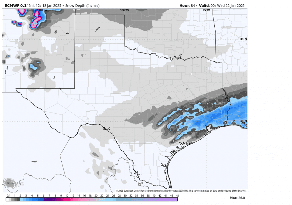
Continue to monitor the latest weather forecasts and updates.
Bob
Arctic Air Arriving Saturday. Increasing Confidence for Wintery Precipitation Late Monday
Weather Highlights:
- Very cold air will arrive late Saturday and remain across the area through next Thursday
- Windy conditions will develop Saturday evening and persist into Tuesday. Expect gusts to near 30 mph.
- Readings close to 20 degrees are forecast across the entire region Tuesday night into Wednesday morning
- There is now medium confidence in the threat for wintery precipitation, mainly in form of snow, for the eastern Hill Country, Central Texas, and coastal areas late Monday through midday Tuesday
Discussion
Forecasts continue to call for an outbreak of arctic air into Texas this weekend, with the cold remaining in place through late next week. Friday’s data doesn’t show any significant change in the magnitude of the cold air headed our direction. Hard freezes are forecast across the entire region Sunday, Monday, Tuesday, and Wednesday nights. Monday and Tuesday nights are shaping up to be the coldest nights of the week. Preparations for the cold air should be rushed to completion Friday afternoon and Saturday morning.
Friday morning, the leading edge of the unusually cold air mass was located over southwestern Canada, about 300 miles north of US/Canadian border. The very cold air will plunge to the south Friday afternoon into Saturday and will begin to be felt Saturday evening when readings begin to fall through the 40s.
Winds behind the cold front are forecast to increase to a range of 10-15 mph, with occasional gusts to 30/35 mph. The windy conditions are forecast to persist Sunday into Monday as additional arctic air continues to spill into Texas.
The combination of the strong winds and the very cold air is expected to produce wind chill temperatures in teens Sunday, Monday, and Tuesday mornings.
Sunny and dry weather is forecast Saturday and Sunday. Clouds are predicted to increase across the area Monday afternoon and remain overcast Monday night into Tuesday afternoon. (More on the threat for precipitation below). Clouds are forecast to clear Tuesday afternoon, followed by a sunny sky next Wednesday.
A update on low temperatures forecast through late next week:
- Sunday morning: Low and mid-20s Hill Country, upper 20s Central Texas, and lower 30s coastal area
- Monday morning: Near 20 degrees across the Hill Country, in the low 20s across Central Texas, mid and upper 20s coastal plains
- Tuesday morning: Low 20s Hill Country, mid-20s across Central Texas, and upper 20s coastal plains
- Wednesday morning: A low near 20-22 across the entire region
- Thursday morning: Mid and upper 20s Hill Country and Central Texas regions, and near 30-32 degrees coastal plains
The disagreement among the forecast solutions discussed yesterday changed with the Thursday night model runs. The majority of the forecast guidance has now come into general agreement regarding the trough of low pressure moving across Texas late Monday, and moisture returning inland ahead of the trough. While the solutions all call for a threat for wintery precipitation, there is still some disagreement as to just how much precipitation will fall.
Initially, a mixed area of precipitation consisting of rain/freezing rain and sleet is forecast to develop across the coastal plains region, generally along and south of Intestate 10, Monday evening. The area of precipitation is predicted to change over to mostly snow across this area after midnight Monday night. To the north, forecasts call for an area of mostly light snow to develop Monday evening and Monday night across Central Texas, extending west into the eastern Hill Country. The light snow is forecast to continue into Tuesday morning, with the precipitation ending by midday Tuesday.
The probability for precipitation will be near 40 percent across the eastern Hill Country and all of Central Texas, while the probability for precipitation is forecast to be near 60 percent across the coastal plains.
Snow accumulations through midday Tuesday are forecast to be less than an inch across the Hill Country and most of Central Texas. Snow and ice accumulations may actually be higher (greater than an inch) across the coastal plains region where moisture will be more plentiful.
Pasted below is the forecast accumulation of snow from the Friday morning European forecast solution. I would use this as a guide to where the precipitation is forecast to fall and a feel for the different magnitudes of snow possible. Again, this is not an official forecast and just an idea from one of the forecast solutions. This forecast has the potential to change over the next couple of days.
Forecast snow depth through noon Tuesday from the ECMWF model:
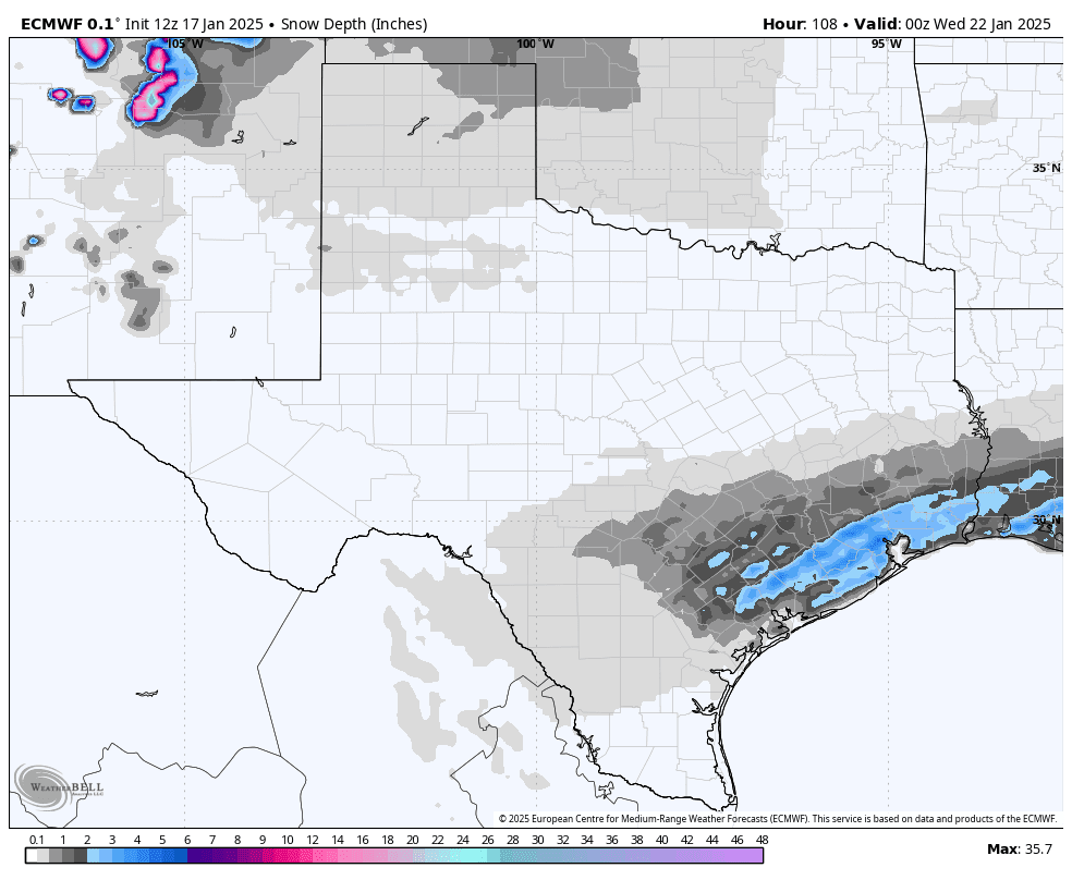 Milder temperatures are forecast late next week into next weekend.
Bob
Thursday Arctic Outbreak Update
Highlights
- An arctic cold front will arrive early Saturday, bringing much colder air that will last through the middle of next week. Low temperatures will likely be in the 20s with afternoon highs only in the 30s to low 40s for most areas Sunday and Monday.
- Forecasters continue to monitor the potential for winter weather next Monday and Tuesday. The latest forecast guidance continues show some potential for light wintry precipitation across the area late Monday into Tuesday, but there is still significant uncertainty in how much moisture will return to produce precipitation
- Preparations should be made now for this upcoming extended period of very cold weather
Discussion
An extended period of very cold weather continues to be forecast for Texas this weekend through the middle of next week. The latest temperature forecast hasn’t changed significantly from the past couple of days. The coldest point of this cold period is expected to be Sunday night and Monday night. The arctic air is predicted to begin moving off to the east Wednesday, followed by milder readings Thursday into the following weekend.
The leading edge of the cold air is predicted to reach the Hill Country before sunrise Saturday, with the cold front moving pushing off the coast before noon. No rain is expected along the front. Temperatures are forecast to hold in the 50s Saturday afternoon. A surge of much colder air is then expected to arrive Saturday evening which will cause the temperature to drop significantly Saturday evening and Saturday night. Readings are forecast to fall below freezing at most locations Sunday morning. Additional surges of arctic air are predicted to arrive Sunday through Tuesday, keeping the temperature very chilly!
Breezy to windy conditions are forecast to develop Saturday as the arctic air pushes south. Expect northerly winds with speeds of 10-20 mph and gusts to near 30 mph Saturday night through Monday night.
The combination of the very cold air and the strong and gusty winds is expected to produce unusually cold wind chill, or feel-like temperatures, Saturday night through Tuesday morning. Spots across the Hill Country could see wind chill readings in the low teens while most other areas will see wind chill readings in the mid and upper teens.
Here’s a review of high and low temperatures expected with the upcoming cold spell:
Lows:
- Lows Sunday morning will include the low and mid-20s across the Hill Country, the upper 20s across Central Texas, and be near 30-032 degrees across the coastal plain
- Lows Monday morning are forecast to be near 20 degrees across the Hill Country, in the low 20s across Central Texas, and in the mid to upper 20s across the coastal plains
- Lows Tuesday and Wednesday mornings are forecast to be in the low 20s across the Hill Country, the mid-20s across Central Texas and the upper 20s across the coastal area
- Lows Thursday morning will range from the upper 20s across the Hill Country, to the low 30s across Central Texas and the coastal plains
- Lows Friday morning are forecast to be in the low and mid-30s
Highs:
- High temperatures Sunday will range from the upper 30s across the Hill Country, to the mid-40s across the coastal plains
- High temperatures Monday and Tuesday will include the mid-30s across the Hill Country, the upper 30s across Central Texas, and the low 40s across the coastal area
- High temperatures Wednesday will range from the low 40s west, the upper 40s near the coast
- High temperatures Thursday and Friday are forecast to be in the upper 40s and low 50s
The forecast for wintery precipitation next week remains fairly uncertain. The forecast solutions call for a trough of low pressure to dive southeast across the western U.S. this weekend and move across Texas early Texas next week. The uncertainty for precipitation arises from how much Gulf moisture is pulled into Texas with the trough. There just isn’t a clear consensus. Some of the solutions call for a weak trough that will barely pull any moisture into the state. This solution would result in little to no precipitation across Central and South Texas. Meanwhile, other solutions call for a modest return of moisture across the Hill Country, Central Texas, and coastal regions late Monday through Tuesday afternoon. If these solutions are correct, the returning moisture will have the potential to cause some light snow showers and freezing rain.
I am leaning toward the solutions that produces at least some wintery precipitation across the area Monday evening through late Tuesday afternoon. For the Hill Country and Central Texas regions, this means a 30-40 percent chance for freezing rain and snow showers Monday night, followed by a 30-40 percent chance for mainly snow showers Tuesday. Areas south of Interstate 10 will see a 50 percent chance for freezing rain and some snow showers Monday night through Tuesday afternoon.
Slightly higher accumulations will be possible here due to a greater amount of atmospheric moisture.
Due to limited moisture returning off the Gulf, general precipitation amounts, if any, should be low.
Again, there is much uncertainty in the forecast for wintery precipitation. The forecast should improve over the next couple of days when we move into the window of the high-resolution forecast models.
Sunny weather looks to return Wednesday, followed by a cloudy sky with a chance for rain Thursday and Friday.
Bob
Another Arctic Blast Headed for Texas
…Sub-freezing Temperatures and Hard Freezes Likely Next Week…
Another blast of arctic air appears headed toward Texas this weekend, with the cold air expected to continue through the middle of next week. The various computer-forecast solutions have come into fairly good agreement in calling for a mass of very cold Siberian air to move over the Pole the next couple of days, then plunge south across Canada and the central U.S. late week. Forecasts call for the leading edge of the arctic air to spread south across Texas Saturday afternoon, followed by windy and much colder weather Saturday night through the first half of next week. This next blast of arctic air is looking to be even colder than the what we experienced from last week’s cold blast. Behind the cold front, north and northwesterly winds will increase to 15-25 mph, with gusts to 35/40 mph Saturday night through Sunday night.
Temperatures:
Based on the latest forecast guidance, here is an idea of the high and low temperatures that can be expected. These reading are not final and will likely change some—especially we move into the window of the high resolution-forecast models.
High temperatures:
- Saturday: Highs will range from the upper 50s to low 60s across the Hill Country, to the mid-60s across Central Texas, to the upper 60s near the coast
- Sunday: Highs will range from the low 40s across the Hill Country, to the mid-40s across Central Texas, to the upper 40s across the coastal plains
- Monday: High temperatures generally in the upper 30s to low 40s
- Tuesday: High temperatures generally in the mid and upper 30s
- Wednesday: Highs in the low and mid-40s
- Thursday: Highs in the low 50s
Low temperatures
- Sunday: Lows Sunday morning will include the mid and upper 20s across the Hill Country, the upper 20s across Central Texas, and the low 30s across the coastal plains
- Monday: Lows Monday morning will include the upper teens to 20 degrees across the Hill Country, the low 20s across Central Texas, and the mid-20s across the coastal plains
- Tuesday: Lows Tuesday morning will include the upper teens to low 20s across the Hill Country, the low to mid-20s across Central Texas, and the upper 20s across the coastal plains
- Wednesday: Lows Wednesday morning are forecast to be in the low to mid-20s across the Hill Country, the upper 20s across Central Texas, and near 30 degrees across the coastal plains
- Thursday: Lows Thursday morning are forecast to be in the mid and upper 20s across the Hill Country, the upper 20s to low 30s across Central Texas, and the mid-30s across the coastal plains
Precipitation
The latest forecast solutions call for no precipitation immediately behind the cold front Saturday night through Sunday. Early next week, some of the forecast solutions call for a weak trough of low pressure to track east across the southern half of the state that could pull some moisture north from the Gulf of Mexico. It’s too early to know if this system could cause any wintery precipitation. As of now, the majority of the forecast solution keep weather conditions dry during the first half of next week, but this could change. The precipitation forecast is currently highly uncertain and it will likely be a few more days before forecasters can get a better handle on the potential for any wintery weather.
I urge everyone to monitor forecasts over the next few days for further updates and prepare for the return of some very cold temperatures this weekend.
Bob
Dry Weather through Late Next Week. Temperatures Trending Milder Late in the Week
Here’s an update on this weekend’s weather and an outlook for the next week.
Weather Highlights Over the Next Week
- Dry weather is forecast over the weekend, continuing through late next week
- A hard freeze is forecast across the Hill Country and much of Central Texas Friday night
- Temperatures will remain cool through the first half of next week. Milder readings will develop for the second half of next week
Discussion
The storm system which brought widespread rain to the region Thursday has exited to the northeast. Fortunately, temperatures were just warm enough at the surface and in the lower atmosphere to keep most of the precipitation liquid. The National Weather Service did receive scattered reports of light glazing of ice on elevated surfaces, such as trees, fences, and metal signs across Edwards, Kerr, Gillespie, and northern Kendall Counties. However, there no reports of icing on roadways from across the area.
Thursday’s storm system did bring the first widespread, soaking rain to the area in quite some time. According to LCRA’s Hydromet, Thursday’s totals averaged around a half inch across the western half of the Hill Country, and between 1 and 1.25 inches over the eastern half. Across Central Texas, most totals were in the range of 1-1.5 inches. South of Interstate 10, totals were generally between 2 and 3 inches. LCRA’s highest gauged total was 3.23 inches near Sargent, along the coast in southeastern Matagorda County.
Breezy, dry, and chilly weather conditions are in place in the wake of the departing low pressure system. A strong pressure gradient on the back side of the low will cause strong northwesterly winds with speeds of 10-20 mph and gusts to 30 mph through Friday evening. Wind speeds are forecast to decrease to around 5-10 mph by midnight Friday night. An area of moisture wrapping around the exiting low pressure system will likely keep Friday’s sky mostly cloudy. The sky is predicted to clear from west to east Friday evening.
Some of the coldest temperatures we’ve seen all week are expected to develop Friday night as the sky clears and the wind decreases. Much of the Hill Country and parts of Central Texas could see a hard freeze.
- High temperatures Friday will range from around 40 degrees across the Hill Country, to the mid-40s across the coastal plains
- Low temperatures Saturday morning will include the low 20s across the Hill Country, the mid-20s across Central Texas, and the upper 20s to 30 degrees towards the coast
Sunny, dry, and slightly warmer weather is forecast this weekend as our region comes under the influence of a dry and stable wind flow in the middle and upper atmosphere. Forecasts do call for a cold front to push south across the area Sunday, bringing a reinforcing shot of chilly air. The atmosphere looks to be too dry for any precipitation to develop along the cold front.
- High temperatures Saturday are forecast to be in the low and mid-50s
- Lows Sunday morning are predicted to generally be in the low 30s, with mid-30s for the coastal area
- High temperatures Sunday are forecast to be in the mid and upper 50s
- Lows Monday morning will include the mid and upper 20s across the Hill Country, the low 30s across Central Texas, and the mid-30s across the coastal plains
Next week’s weather is expected to be most sunny and dry as a weak ridge of high pressure spreads over Texas out of the southwestern U.S. Sunday’s cold front is expected to bring in cooler air for Monday and Tuesday. Light freezes are forecast across the Hill Country and Central Texas regions Monday and Tuesday mornings. Milder temperatures look to develop the second half of the week, continuing into next weekend.
- High temperatures Monday and Tuesday are forecast to be in the mid-50s
- Highs Wednesday through Friday are forecast to be in the upper 50s
- High temperatures next Saturday are forecast to reach close to 70 degrees
- Lows Tuesday and Wednesday mornings are predicted to be in the mid and upper 30s
- Lows Thursday through Saturday are predicted to be in the low and mid-40s
Looking out a little further, forecasts are calling for another surge of cold air to push south across Texas sometime around January 20th, that will bring colder temperatures. Some of the solutions show the cold air being similar in magnitude to what we saw this week, with others call for colder temperatures. Stay tuned for further updates.
Four Planets Visible Now in the Evening Sky
- Venus shines very high and bright as the “Evening Star” in the southwest during twilight and lower in the west-southwest as evening grows late. It doesn’t set until about 2½ hours after dark
- As darkness deepens you can spot Saturn, much fainter, upper left or left of Venus and closing in on it day by day
- Mars is at opposition this week, glaring at bright magnitude –1.4 It comes into view as a steady orange spark low in the east-northeast sky during twilight
- Jupiter, more than a month past its own opposition, shines at a very bright magnitude –2.7. It dominates the high east to southern sky during evening, with fainter Aldebaran (orangeand the Pleiades nearby. Jupiter is still a good 45 arcseconds wide
Have a great weekend!
Bob
Widespread Precipitation through Thursday Night. Sunny and a Little Warmer this Weekend
The much anticipated storm system is now moving across Texas, bringing a variety of weather types. 3 pm temperatures were generally in the mid and upper 30s across the Austin and Central Texas region and in the low 40s to mid-50s across the coastal plains. Most Hill Country temperatures were reported as being just above the freezing mark. Doppler weather radar at 3 pm showed a large area of mostly light precipitation spreading east across the Hill Country and Central Texas regions. There have been some isolated reports of light icing from the Hill Country. But according to TXDOT’s https://drivetexas.org web page at 3 pm, road conditions across Central Texas, the Hill Country, and West Texas remain in good shape. Light rain covered most of Central Texas, while an area of heavier rain was spreading across the area between La Grange and Columbus.
Forecasts call for widespread precipitation to continue across the area this afternoon and tonight. The temperature is predicted to hold fairly steady—in the mid-30s across the Hill Country and the upper 30s across Central Texas. Across the coastal plains, temperatures are forecast to fall to the upper 30s to low 40s.
For the Hill Country, a light to occasionally moderate rain is forecast to continue this afternoon and tonight. Some occasional snow showers will be possible after midnight, with little to no snow accumulation. Rain totals through 6 am Friday are forecast to average between 0.5 and 1 inch. All of the precipitation should come to an end by daybreak Friday. A Winter Weather Advisory remains posted for the area through 6 am Friday.
For Central Texas, widespread light to moderate rain is forecast to will continue through Thursday night. The rain should taper off by daybreak Friday. Rain amounts through 6 am Friday are predicted to generally be between 1 and 1.5 inches.
For the middle Texas coast, periods of moderate rain are forecast this afternoon through late Thursday night. The rain should diminish around daybreak Friday. Rain amounts through 6 am Friday are forecast to average between 1 and 2 inches.
A Winter Weather Advisory Continues for the highlighted counties through 6 am Friday:

The outlook for Friday calls for a mostly cloudy sky, dry weather, and cool temperatures as the storm system exits to the northeast. High temperatures will range from upper 30s across the Hill Country, to the low 40s across Central Texas, to mid and upper 40s across the coastal plains.
Quite cold temperatures are forecast Friday night as the sky clears. Lows Saturday morning are forecast to be in the low and mid-20s across the Hill Country, in the mid 20s across Central Texas, and around 28-30 degrees across the coastal plains.
Sunny and slightly warmer weather is forecast for the weekend.
Bob


Social Media