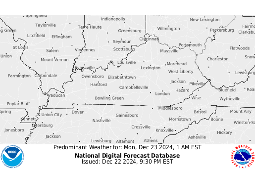
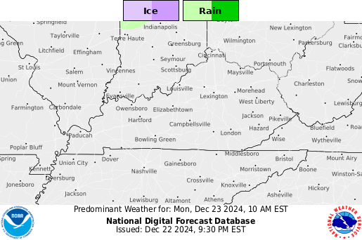
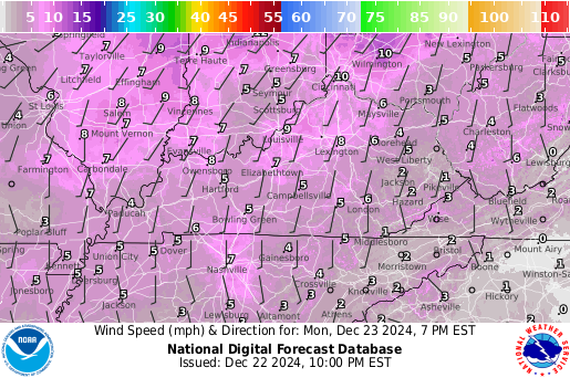
*********************************************************/ // 7 variables to control behavior var Car_Image_Width=550; var Car_Image_Height=450; var Car_Border=true; // true or false var Car_Border_Color="white"; var Car_Speed=1; var Car_Direction=true; // true or false var Car_NoOfSides=12; // must be 4, 6, 8 or 12 /* array to specify images and optional links. For 4 sided carousel specify at least 2 images For 6 sided carousel specify at least 3 For 8 sided carousel specify at least 4 For 12 sided carousel specify at least 6 If Link is not needed keep it "" */ Car_Image_Sources=new Array( "/gifs/ukag.gif","/gifs/ukag.gif", "http://graphical.weather.gov/images/kentucky/MaxT1_kentucky.png","http://graphical.weather.gov/images/kentucky/MaxT1_kentucky.png", "http://graphical.weather.gov/images/kentucky/MinT1_kentucky.png","http://graphical.weather.gov/images/kentucky/MinT1_kentucky.png", "http://graphical.weather.gov/images/kentucky/MaxT2_kentucky.png","http://graphical.weather.gov/images/kentucky/MaxT2_kentucky.png", "http://graphical.weather.gov/images/kentucky/MinT2_kentucky.png","http://graphical.weather.gov/images/kentucky/MinT2_kentucky.png", "http://graphical.weather.gov/images/kentucky/Wx3_kentucky.png","http://graphical.weather.gov/images/kentucky/Wx3_kentucky.png", "http://graphical.weather.gov/images/kentucky/Wx6_kentucky.png","http://graphical.weather.gov/images/kentucky/Wx6_kentucky.png", "http://graphical.weather.gov/images/kentucky/Wx9_kentucky.png","http://graphical.weather.gov/images/kentucky/Wx9_kentucky.png", "http://graphical.weather.gov/images/kentucky/Wx12_kentucky.png","http://graphical.weather.gov/images/kentucky/Wx12_kentucky.png", "http://radar.weather.gov/Conus/Loop/NatLoop_Small.gif","http://radar.weather.gov/Conus/Loop/NatLoop_Small.gifng", "http://radar.weather.gov/ridge/lite/NCR/PAH_loop.gif","http://radar.weather.gov/ridge/lite/NCR/PAH_loop.gif", "http://radar.weather.gov/ridge/lite/NCR/LVX_loop.gif","http://radar.weather.gov/ridge/lite/NCR/LVX_loop.gif", "http://radar.weather.gov/ridge/lite/NCR/JKL_loop.gif","http://radar.weather.gov/ridge/lite/NCR/JKL_loop.gif", "http://water.weather.gov/ahps/images/national/conus_all_obs.png","http://water.weather.gov/ahps/images/national/conus_all_obs.png", "http://water.weather.gov/ahps/images/national/conus_all_fcst.png","http://water.weather.gov/ahps/images/national/conus_all_fcst.png", "http://www.wpc.ncep.noaa.gov/qpf/p120i12.gif","http://www.wpc.ncep.noaa.gov/qpf/p120i12.gif", "http://www.wpc.ncep.noaa.gov/qpf/94ewbg.gif","http://www.wpc.ncep.noaa.gov/qpf/94ewbg.gif", "/gifs/ukag.gif","/gifs/ukag.gif", "http://www.crh.noaa.gov/images/fxc/pah/wx/File.png","http://www.crh.noaa.gov/images/fxc/pah/wx/File.png", "http://www.crh.noaa.gov/images/fxc/lmk/wx/File.png","http://www.crh.noaa.gov/images/fxc/lmk/wx/File.png", "http://www.crh.noaa.gov/images/fxc/jkl/wx/File.png","http://www.crh.noaa.gov/images/fxc/jkl/wx/File.png", "http://graphical.weather.gov/images/kentucky/ApparentT7_kentucky.png","http://graphical.weather.gov/images/kentucky/ApparentT7_kentucky.png", "http://graphical.weather.gov/images/kentucky/ApparentT12_kentucky.png","http://graphical.weather.gov/images/kentucky/ApparentT12_kentucky.png", "http://graphical.weather.gov/images/kentucky/ApparentT17_kentucky.png","http://graphical.weather.gov/images/kentucky/ApparentT17_kentucky.png", "http://graphical.weather.gov/images/kentucky/ApparentT23_kentucky.png","http://graphical.weather.gov/images/kentucky/ApparentT23_kentucky.png", "http://graphical.weather.gov/images/kentucky/PoP121_kentucky.png","http://graphical.weather.gov/images/kentucky/PoP121_kentucky.png", "http://graphical.weather.gov/images/kentucky/PoP122_kentucky.png","http://graphical.weather.gov/images/kentucky/PoP122_kentucky.png", "http://graphical.weather.gov/images/kentucky/PoP123_kentucky.png","http://graphical.weather.gov/images/kentucky/PoP123_kentucky.png", "http://graphical.weather.gov/images/kentucky/PoP124_kentucky.png","http://graphical.weather.gov/images/kentucky/PoP124_kentucky.png", "http://graphical.weather.gov/images/kentucky/WindSpd3_kentucky.png","http://graphical.weather.gov/images/kentucky/WindSpd3_kentucky.png", "http://graphical.weather.gov/images/kentucky/WindSpd6_kentucky.png","http://graphical.weather.gov/images/kentucky/WindSpd6_kentucky.png", "http://graphical.weather.gov/images/kentucky/WindSpd9_kentucky.png","http://graphical.weather.gov/images/kentucky/WindSpd9_kentucky.png", "http://graphical.weather.gov/images/kentucky/WindSpd12_kentucky.png","http://graphical.weather.gov/images/kentucky/WindSpd12_kentucky.png", "http://graphical.weather.gov/images/kentucky/Sky4_kentucky.png","http://graphical.weather.gov/images/kentucky/WindSpd4_kentucky.png", "http://graphical.weather.gov/images/kentucky/Sky8_kentucky.png","http://graphical.weather.gov/images/kentucky/WindSpd8_kentucky.png", "http://graphical.weather.gov/images/kentucky/Sky12_kentucky.png","http://graphical.weather.gov/images/kentucky/WindSpd12_kentucky.png", "http://graphical.weather.gov/images/kentucky/Sky16_kentucky.png","http://graphical.weather.gov/images/kentucky/WindSpd16_kentucky.png", "/gifs/ukag.gif","/gifs/ukag.gif", "http://www.spc.noaa.gov/products/activity_loop.gif","http://www.spc.noaa.gov/products/activity_loop.gif", "http://www.ssec.wisc.edu/data/east/latest_eastir.gif","http://www.ssec.wisc.edu/data/east/latest_eastir.gif", "http://www.ssec.wisc.edu/data/east/latest_eastvis.gif","http://www.ssec.wisc.edu/data/east/latest_eastvis.gif", "http://www.spc.noaa.gov/products/wwa/wwa.gif","http://www.spc.noaa.gov/products/wwa/wwa.gif", "http://www.wunderground.com/data/640x480/2xradarb4_anim.gif","http://www.wunderground.com/data/640x480/2xradarb4_anim.gif", "http://radar.weather.gov/ridge/Conus/Loop/centgrtlakes_loop.gif","http://radar.weather.gov/ridge/Conus/Loop/centgrtlakes_loop.gif", "/ldm-images/latestus2.gif","/ldm-images/latestus2.gif", "/ldm-images/latestwind.gif","/ldm-images/latestwind.gif", "http://www.wpc.ncep.noaa.gov/qpf/fill_94qwbg.gif","http://www.wpc.ncep.noaa.gov/qpf/fill_94qwbg.gif", "http://www.wpc.ncep.noaa.gov/qpf/p120i12.gif","http://www.wpc.ncep.noaa.gov/qpf/p120i12.gif", "/ldm-images/latestwci2.gif","/ldm-images/latestwci2.gif", "/ldm-images/latestdewp.gif","/ldm-images/latestdewp.gif", "http://weather.unisys.com/images/sat_sfc_map_loop.gif","http://weather.unisys.com/images/sat_sfc_map_loop.gif", "http://www.wpc.ncep.noaa.gov/noaa/noaa.gif","http://www.wpc.ncep.noaa.gov/noaa/noaa.gif", "http://www.wpc.ncep.noaa.gov/noaa/noaad2.gif","http://www.wpc.ncep.noaa.gov/noaa/noaad2.gif", "http://www.wpc.ncep.noaa.gov/noaa/noaad3.gif","http://www.wpc.ncep.noaa.gov/noaa/noaad3.gif", "/gifs/ukag.gif","/gifs/ukag.gif", "http://adds.aviationweather.gov/data/progs/wpc_12_fcst.gif","http://adds.aviationweather.gov/data/progs/hpc_12_fcst.gif", "http://adds.aviationweather.gov/data/progs/wpc_24_fcst.gif","http://adds.aviationweather.gov/data/progs/hpc_24_fcst.gif", "http://adds.aviationweather.gov/data/progs/wpc_36_fcst.gif","http://adds.aviationweather.gov/data/progs/hpc_36_fcst.gif", "http://adds.aviationweather.gov/data/progs/wpc_48_fcst.gif","http://adds.aviationweather.gov/data/progs/hpc_48_fcst.gif", "http://www.wpc.ncep.noaa.gov/basicwx/allfcsts_loop_wbg.gif","http://www.wpc.ncep.noaa.gov/basicwx/allfcsts_loop_wbg.gif", "/ldm-images/nhmrf_3-5.tst.gif","/ldm-images/nhmrf_3-5.tst.gif", "http://www.cpc.ncep.noaa.gov/products/predictions/threats/hazards_d3_7.png","http://www.cpc.ncep.noaa.gov/products/predictions/threats/hazards_d3_7.png", "/ldm-images/eta_850_ani.gif","/ldm-images/eta_850_ani.gif", "/ldm-images/eta_500_ani.gif","/ldm-images/eta_500_ani.gif", "/ldm-images/nhmrf_thick_ani.gif","/ldm-images/nhmrf_thick_ani.gif" // NOTE No comma after last line ); /***************** DO NOT EDIT BELOW **********************************/ CW_I=new Array(Car_NoOfSides/2+1);C_ClcW=new Array(Car_NoOfSides/2); C_Coef=new Array( 3*Math.PI/2,0,3*Math.PI/2,11*Math.PI/6,Math.PI/6,3*Math.PI/2,7*Math.PI/4, 0, Math.PI/4,3*Math.PI/2,5*Math.PI/3,11*Math.PI/6,0,Math.PI/6,Math.PI/3); var C_CoefOf=Car_NoOfSides==4?0:Car_NoOfSides==6?2:Car_NoOfSides==8?5:9; C_Pre_Img=new Array(Car_Image_Sources.length); var C_Angle=Car_Direction?Math.PI/(Car_NoOfSides/2):0,C_CrImg=Car_NoOfSides,C_MaxW,C_TotalW, C_Stppd=false,i,C_LeftOffset,C_HalfNo=Car_NoOfSides/2; function Carousel(){ if(document.getElementById){ for(i=0;i=Math.PI/C_HalfNo)){ if(C_CrImg==Car_Image_Sources.length)C_CrImg=0; if(Car_Direction){ CW_I[C_HalfNo]=CW_I[0]; for(i=0;i0;i--)CW_I[i]=CW_I[i-1]; CW_I[0]=CW_I[C_HalfNo]; CW_I[0].src=Car_Image_Sources[C_CrImg]; CW_I[0].lnk=Car_Image_Sources[C_CrImg+1]} C_Angle=Car_Direction?Math.PI/C_HalfNo:0;C_CrImg+=2}} setTimeout("CarImages()",50)} function C_LdLnk(){if(this.lnk)window.location.href=this.lnk} function C_Stp(){this.style.cursor=this.lnk?"pointer":"default";C_Stppd=true;} function C_Rstrt(){C_Stppd=false}
-=-=-=-=-=-=-Severe Weather Safety Tips Click Here-=-=-=-=-=- What is UTC time? Click here to find out.... Mouseover to pause!......Kentucky Short-term forecast... Detailed forecast information is available in your Precision Ag Weather forecast here... -=-=-=-=-=-=-=-=-=-=-=-=-=-=-=- Long-range outlooks here.
UKAWC Weather Map Carousel

Last update: Sun Dec 22 16:43:24 EST 2024
[US Rad], [IR Sat], [VIS], [WW], [NatRad], [Temps], [LSI], [Wind], [QPF], [5-day], [WCI], [DewP], [Sat/Sfc/Rad], [Today], [Tom.], [NextDay], [12Hr], [24Hr], [36Hr], [36Hr], [48Hr], [60Hr], [3-5 day], [7-day Threats] [850mb], [500mb], [Thick], ALL , wxcarousel2
Webcasts: County NWS Hazardous Weather, Hourly Ag Weather Conditions, Kentucky Ag Weather Synopsis, w/Maps, Kentucky Weekly Climate Report, w/Maps, Kentucky Weather & Crop Report,
Select radar by NWS office
To stop the weather map carousel, place the mouse over the map (Page will refresh every 10 minutes) :
Mouseover to pause!...... -=-=-=-=-=-=-Severe Weather Safety Tips Click Here-=-=-=-=-=- ...The mission of the UK Agricultural Weather Program/Center is to provide educational resources through the development of agricultural weather products and services that minimize weather surprise to Kentucky residents relative to their agricultural needs... Detailed forecast information is available in your Precision Ag Weather forecast here... -=-=-=-=-=-=-Severe Weather Safety Tips Here-=-=-=-=-=- Long-range outlooks here.

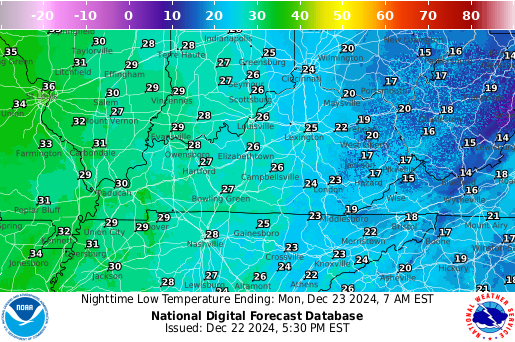
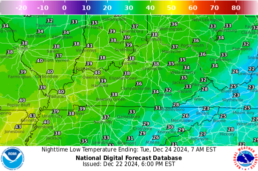
Temperature

Next 12 Hrs
Next 24 Hrs
Next 36 Hrs
Next 48 Hrs

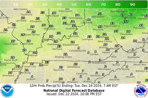
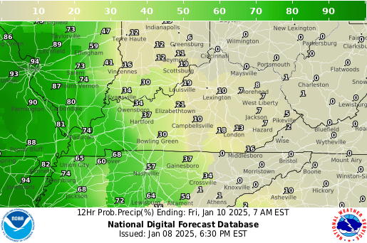
Probability of Precipitation

Next 12 Hrs
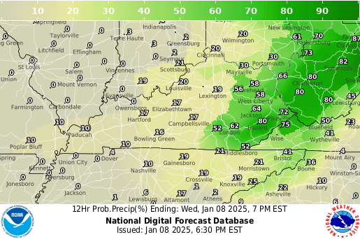
Next 24 Hrs
Next 36 Hrs
Next 48 Hrs

Weather Conditions

Next 12 Hrs
Next 24 Hrs
Next 36 Hrs
Next 48 Hrs

Winds

Next 12 Hrs
Next 24 Hrs
Next 36 Hrs
Next 48 Hrs
pFad - Phonifier reborn

Pfad - The Proxy pFad of © 2024 Garber Painting. All rights reserved.

Note: This service is not intended for secure transactions such as banking, social media, email, or purchasing. Use at your own risk. We assume no liability whatsoever for broken pages.


Alternative Proxies:

Alternative Proxy

pFad Proxy

pFad v3 Proxy

pFad v4 Proxy