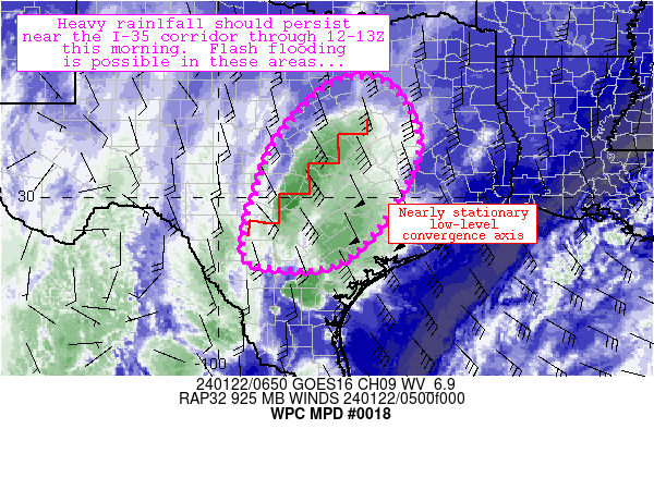
Mesoscale Precipitation Discussion 0018
NWS Weather Prediction Center College Park MD
206 AM EST Mon Jan 22 2024

Areas affected...portions of central and south Texas

Concerning...Heavy rainfall...Flash flooding possible

Valid 220702Z - 221302Z

Summary...Deep convection has began to expand in coverage across
the San Antonio Metro and surrounding areas, with locally heavy
rainfall already observed.  These trends should continue through
at least 12Z, with local 2-4+ inch amounts expected where training
of storms can occur.  Flash flooding is possible.

Discussion...Over the past couple hours, robust convective
development has occurred in earnest especially around the San
Antonio Metro area.  The cells have formed in clusters and bands
roughly parallel to southwesterly steering flow aloft, which has
allowed for local spots of 1-2 inch/hr rain rates to form over
western sides of San Antonio.   The storms are forming in response
to vigorous mid-level forcing for ascent associated with
approaching shortwave troughs near the Rio Grande.  Cooling aloft
associated with this wave and robust moist advection in the
925-850mb layer were both contributing to ~1000 J/kg MUCAPE across
the region along with relatively focused convergence near the
convection.

Models and observations both support the notion that the ongoing
convective axis will not move much from the I-35 corridor in Texas
as convection expands through 12Z.  This will allow ample
opportunity for convective repeating and training during that
timeframe, along with highly localized potential for rainfall
totals to exceed 3 inches in a short amount of time.  The 00Z
high-res Nam seems to have a decent handle on this potential, with
heavier rainfall totals (appraoching 5 inches) potentially
occurring near the Austin/San Antonio Metro areas that are already
sensitive from urbanized land surfaces.  FFGs are in the 1-2
inch/hr range over the urbanized areas and higher (2.5 inch/hr) in
more rural areas east of the I-35 corridor.  These rates will be
approached or exceeded especially where localized training can
materialize.  Flash flooding is possible, especially in and near
Austin/San Antonio through the early morning hours.

Cook

ATTN...WFO...CRP...EWX...FWD...HGX...SJT...

ATTN...RFC...WGRFC...NWC...

LAT...LON   32429753 32379633 30889575 28699724 28559923
            29149945 29869927 31279870
Download in GIS format: Shapefile
| KML
Note: This service is not intended for secure transactions such as banking, social media, email, or purchasing. Use at your own risk. We assume no liability whatsoever for broken pages.
Alternative Proxies: