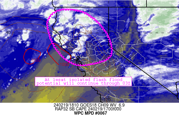
Mesoscale Precipitation Discussion 0067
NWS Weather Prediction Center College Park MD
132 PM EST Mon Feb 19 2024

Areas affected...portions of northern and central California

Concerning...Heavy rainfall...Flash flooding possible

Valid 191831Z - 200031Z

Summary...Areas of rainfall and isolated thunderstorms continue to
migrate northward across the discussion area.  The heavier
rainfall will help to maintain at least an isolated flash flood
risk through the next 6 hours or so.

Discussion...Northern and central California remain under the
influence of a stout mid/upper low over the northeastern Pacific
centered at around 42N, -130W.  Downstream of that low, difluent
southwesterly flow aloft continues to support updrafts and
developing convection in addition to orographic lift from strong
southerly low-level flow (exceeding 45 knots at 850mb in some
areas).  Furthermore, cooling aloft associated with the mid/upper
low and areas of sunshine have allowed for surface-based CAPE
values to increase into the 250-1000 J/kg range especially across
the central Valley and coastal areas.  All of these factors point
to a sustained heavy rainfall threat over the next 3-6 hours, with
occasional deep convection resulting in local rain rates exceeding
0.5 inch/hr at times.

The extent of the heaviest rain rates are in question, however.
Most areas will experience periods of 0.25 inch/hr rain rates at
times as areas of heavier rainfall quickly drift northward.  The
latest thinking is that at least an isolated flash flood risk will
exist in this regime, with perhaps the greatest threat residing in
1) northern coastal ranges from San Francisco northward and 2)
along windward slopes of the Sierra below the freezing level.
Models generally focus the greatest rainfall rates along these
areas through 03Z, where another 1-2 inches of rainfall could
occur through 0330Z.  Localized training of cells should also
occur across the central Valley, prompting at least isolated flash
flood potential there through the afternoon.

Cook

ATTN...WFO...EKA...MFR...MTR...REV...STO...

ATTN...RFC...CNRFC...NWC...

LAT...LON   41772347 41482183 40212041 38731981 37902029
            37542249 38682403 40522476 41402439
Download in GIS format: Shapefile
| KML
Note: This service is not intended for secure transactions such as banking, social media, email, or purchasing. Use at your own risk. We assume no liability whatsoever for broken pages.
Alternative Proxies: