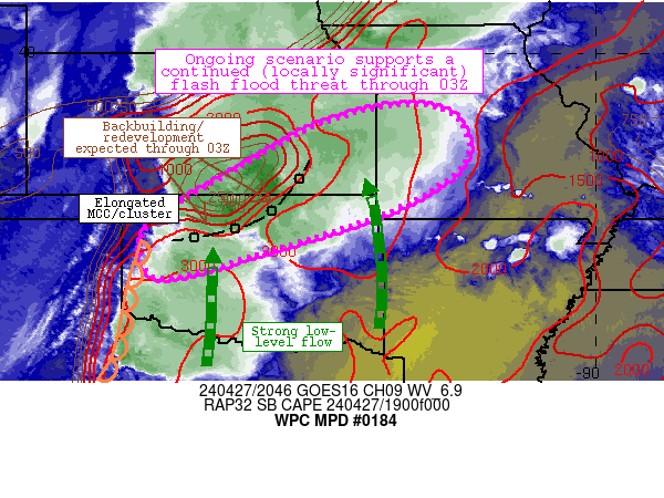
Mesoscale Precipitation Discussion 0184
NWS Weather Prediction Center College Park MD
452 PM EDT Sat Apr 27 2024

Areas affected...northern Oklahoma, southern through eastern
Kansas, western Missouri

Concerning...Heavy rainfall...Flash flooding likely

Valid 272050Z - 280250Z

Summary...Flash flood potential will continue through 03Z as an
intense cluster of convection results in training/repeating cells
across the discussion area.  Areas of 3-6 inch rainfall totals are
expected, and locally significant impacts are possible.

Discussion...A cluster of intense thunderstorms continue to
train/repeat across north-central Oklahoma currently.  MRMS rain
rates of 1-2.5 inch/hr rain rates continue to be detected near
Ponca City and Enid over the past hour, and 3-5 inch totals have
been noted from Enid southwestward toward Roger Mills County over
the past 12 hours.  South of the MCS, a strongly unstable, weakly
capped airmass exists, and strong southerly flow (that will only
increase through 03Z) will maintain convergence along the southern
flanks of ongoing convection, supporting redevelopment over time
generally along an axis from Enid, OK to near/north of Pittsburg,
Kansas.  Additionally, forcing for ascent associated with a
shortwave trough over the Texas South Plains is expected to
impinge on a dryline near the western OK/TX border region and aid
in redevelopment of thunderstorm activity in west-central OK that
should move east-northeastward across the discussion area through
the evening.

In summary, an axis of training/repeating cells appears likely to
develop across the discussion area and produce occasional periods
of 2 inch/hr rain rates (and 3-6 inch rainfall totals - locally
higher).  These rainfall totals could result in significant
impacts especially in sensitive/low-lying areas.  FFG thresholds
are relatively low in southeastern Kansas/western Missouri (around
1 inch/hr), further supportive of an eventual flash flood threat
in that vicinity.

Cook

ATTN...WFO...DDC...EAX...ICT...OUN...SGF...TOP...TSA...

ATTN...RFC...ABRFC...MBRFC...NWC...

LAT...LON   38899369 38629294 37749275 36809406 35889678
            35279920 36149957 36789889 37539756 38369613
            38809478
Download in GIS format: Shapefile
| KML
Note: This service is not intended for secure transactions such as banking, social media, email, or purchasing. Use at your own risk. We assume no liability whatsoever for broken pages.
Alternative Proxies: