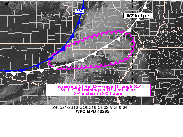
Mesoscale Precipitation Discussion 0299
NWS Weather Prediction Center College Park MD
723 PM EDT Tue May 21 2024

Areas affected...northeastern OK into southern MO/northern AR

Concerning...Heavy rainfall...Flash flooding possible

Valid 212322Z - 220515Z

SUMMARY...Training thunderstorms with rainfall rates of 1-2 in/hr
(possibly up to 3 in/hr on an isolated basis) are expected to
impact northeastern OK into southern MO and northern AR late this
evening into tonight. 2-4 inch totals in 2-3 hours may result in
areas of flash flooding, especially within the more vulnerable
terrain of the Ozarks.

DISCUSSION...23Z radar imagery showed a line of thunderstorms
extending from central MO into northeastern OK, located just ahead
of a cold front. According to the 23Z SPC mesoanalysis, the line
of storms was located within a relatively narrow axis of moderate
to strong instability (MLCAPE 2500-3500 J/kg) with little to no
CIN, just ahead of the cold front. Precipitable water (PW) values
were anomalous with the 20Z SGF sounding sampling 1.3 inches, near
the 95th percentile for middle to late May, but PW values sampled
by GPS observations were higher across the upstream Arklatex with
1.4 to 1.8 inches as of 21Z.

Farther east, scattered, mostly elevated, thunderstorms were
located along the central MO/AR border into western AR and the
Arklatex. These cells were located within a divergent and
diffluent region ahead of a 110-120 kt upper jet positioned over
the Southern Plains, but the cells were moving ENE into a region
of lower instability and greater CIN per SPC mesoanalysis data.

Forecasts from the RAP show the cold front racing east across the
Mid-MS Valley but advancing more slowly across OK through 06Z, out
ahead of a negatively tilted upper level shortwave moving toward
the Upper MS Valley. Lift out ahead of the upper trough and
surface cold front is expected to erode a warm nose located
between 850-700 mb (observed via 20Z SGF sounding), allowing for
increasing coverage of thunderstorms containing a mixture of
surface based (near the cold front) and elevated cells (farther
ahead of the cold front) to affect locations from northeastern OK
into southern MO and northern AR. Cell alignment is expected to
transition to more WSW to ENE, following the forecast movement of
the cold front, supporting areas of training tonight. Rainfall
rates of 1-2 in/hr will be common, but locally 2-3 in/hr cannot be
ruled out along with some 2-4 inch totals in 2-3 hours. Areas of
flash flooding may result, through 05Z.

Otto

ATTN...WFO...LSX...LZK...MEG...OUN...PAH...SGF...TSA...

ATTN...RFC...ABRFC...LMRFC...MBRFC...NCRFC...NWC...

LAT...LON   37699198 37679047 37099003 36089032 35489168
            35229451 35229604 35699627 36319553 36999419
Download in GIS format: Shapefile
| KML
Note: This service is not intended for secure transactions such as banking, social media, email, or purchasing. Use at your own risk. We assume no liability whatsoever for broken pages.
Alternative Proxies: