Mesoscale Precipitation Discussion 0319
NWS Weather Prediction Center College Park MD
734 PM EDT Fri May 24 2024

Areas affected...Eastern MO...Central IL

Concerning...Heavy rainfall...Flash flooding likely

Valid 242330Z - 250330Z

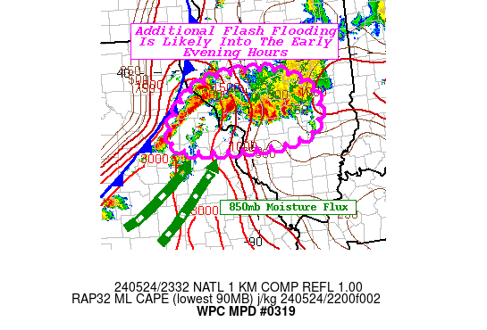
SUMMARY...Additional flash flooding is likely in parts of eastern
MO and central IL that feature highly sensitive soils after as
much as 2-4" of rainfall have fallen over the last few hours.

DISCUSSION...The southwesterly low level moisture flux that
intersected a convergence zone in eastern MO and central IL looks
to continue for at least a couple more hours as a cold front
escorting its own round of storms approaches from the west. MRMS
3-hr QPE shows 2-4" of rainfall has occurred north of St. Louis
with rain still coming down heavily in parts of the area. PWs are
between 1.5-1.75" and MLCAPE is still between 1,000-2,000 J/kg
northwest of St. Louis, just out ahead of the approaching cold
front. With the cold front as the trigger, and no shortage of
effective bulk shear to work with (RAP mesoanalysis shows 40-45
kts of shear present), these storms should continue to pose a
threat for additional flash flooding through the early evening
hours. Areas most prone for additional flash flooding remains the
IL communities north of St. Louis where heavy rainfall has been
unfolding for several hours. Hourly rainfall rates up peaking as
high as 2"/hr are possible. Latest radar trends do suggest strong
storms may track through the St. Louis metro area within the next
hour or so, possibly resulting in urban street ponding in both low
lying spots and poor drainage areas.

Mullinax

ATTN...WFO...ILX...LSX...

ATTN...RFC...MBRFC...NCRFC...OHRFC...NWC...

LAT...LON   39869040 39848931 39438850 38928843 38698864
            38558929 38519034 38619167 39039178 39619128
Download in GIS format: Shapefile
| KML
Note: This service is not intended for secure transactions such as banking, social media, email, or purchasing. Use at your own risk. We assume no liability whatsoever for broken pages.
Alternative Proxies: