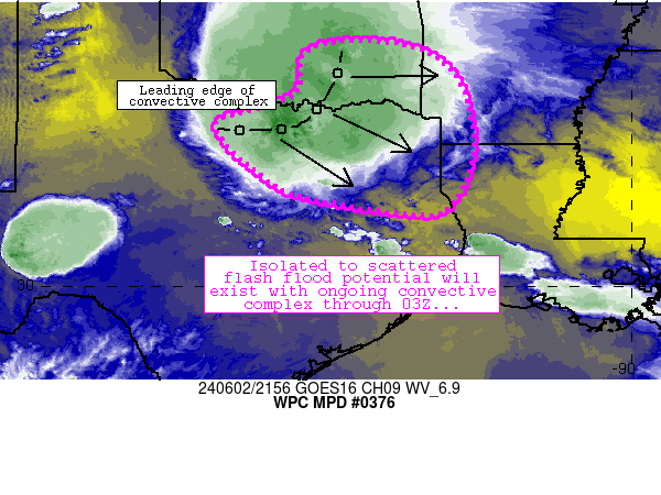
Mesoscale Precipitation Discussion 0376...Corrected
NWS Weather Prediction Center College Park MD
601 PM EDT Sun Jun 02 2024

Corrected for geographical header

Areas affected...southern/southeastern Oklahoma, northern Texas,
northwestern Louisiana, southwestern Arkansas

Concerning...Heavy rainfall...Flash flooding possible

Valid 022200Z - 030400Z

Summary...Flash flood potential continues downstream of an ongoing
convective complex along the Red River Valley.

Discussion...Areas of flash flood potential will continue with an
ongoing convective complex (extending from McAlester to Sherman to
Jacksboro).  The convective complex continues to migrate slowly
east-southeastward (around 20 knots) while moving toward a
strongly unstable and moist environment characterized by 3000+
J/kg MLCAPE and 1.8-2 inch PW values.  Individual storm motions
within the complex have been slow enough to promote areas of 1
inch/hr rain rates, while localized areas of training and cell
mergers were also boosting rain rates at times.  Furthermore, the
region has experienced abundant rainfall over the past couple
weeks, and soil moistures are high - suggestive of runoff
potential.  FFG thresholds are in the 1.5-2 inch/hr range, and
these thresholds will be approached or exceeded locally.

Over time, observations/objective analyses suggest that the MCS
will continue to make more of a southeastward component of motion,
with propagation more toward a pool of strong to extreme buoyancy
located from central into southeast Texas (4000+ J/kg MLCAPE).
Additionally, cells out ahead of the main complex will develop,
move slowly northward, and merge with the ongoing complex (similar
to what is being observed near Dallas-Fort Worth currently).
These mergers will aid in promoting 2 inch/hr rain rates at times,
and instances of flash flooding are expected.  The MCS should
begin to impact portions of the DFW Metroplex over the next 1-2
hours, and migrate southeastward toward the Tyler/Longview areas
closer to 00Z.  Weaker wind fields aloft lend some uncertainty
with respect to eastward extent/persistence of the MCS, although
Texarkana/Shreveport/Lufkin areas may experience flash flood
potential from this activity in the 03-04Z timeframe.

Cook

ATTN...WFO...FWD...LZK...OUN...SHV...TSA...

ATTN...RFC...ABRFC...LMRFC...WGRFC...NWC...

LAT...LON   35189628 35099467 34369368 32859337 31689388
            31549465 31849670 32269773 33409882 33819770
            34209705 34879698
Download in GIS format: Shapefile
| KML
Note: This service is not intended for secure transactions such as banking, social media, email, or purchasing. Use at your own risk. We assume no liability whatsoever for broken pages.
Alternative Proxies: