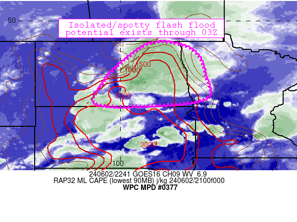
Mesoscale Precipitation Discussion 0377
NWS Weather Prediction Center College Park MD
646 PM EDT Sun Jun 02 2024

Areas affected...central/eastern North Dakota, far northwestern
Minnesota

Concerning...Heavy rainfall...Flash flooding possible

Valid 022245Z - 030445Z

Summary...Scattered convection is training and producing 2-3 inch
rain rates in localized areas.  This regime should continue for
another few hours before picking up speed in the early overnight
hours.  Flash flooding is possible.

Discussion...Areas of convection across central/eastern North
Dakota have recently begun to backbuild and train east of Bismarck
(near Cleveland and Jamestown) over the past couple hours.  The
storms are very near and oriented parallel to a weak boundary
extending from near K96D (Walhalla) southwestward to just east of
KY19 (Manden), with orientation becoming more parallel to
west-southwesterly flow aloft and parallel to the aforementioned
boundary.  The airmass ahead of the boundary (characterized by
2000 J/kg MLCAPE and 1.3 inch PW values) continues to support deep
convection with efficient rainfall rates.  FFGs in the region are
in the 1.5 inch/hr range, and are being exceeded at times beneath
the backbuilding complex. This apparent flash flood threat is
fairly isolated, but persistent and focused beneath the ongoing
activity and should continue in the near term.

Over time, both models and observations suggest that convection
will pickup forward speed to the east mainly due to convective
overturning and modest upscale growth into more progressive linear
segments.  This process will take a few hours to evolve, however,
and it is not out of the question for localized flash flood
potential to eventually reach portions of southeastern North
Dakota (including Fargo) through 01-02Z.

Cook

ATTN...WFO...BIS...FGF...

ATTN...RFC...MBRFC...NCRFC...NWC...

LAT...LON   48929843 48579658 47239596 46319601 46009879
            46080112 46840092 47929999
Download in GIS format: Shapefile
| KML
Note: This service is not intended for secure transactions such as banking, social media, email, or purchasing. Use at your own risk. We assume no liability whatsoever for broken pages.
Alternative Proxies: