Mesoscale Precipitation Discussion 0398
NWS Weather Prediction Center College Park MD
220 AM EDT Wed Jun 05 2024

Areas affected...Red River Valley of the South...Arklatex

Concerning...Heavy rainfall...Flash flooding likely

Valid 050620Z - 051220Z

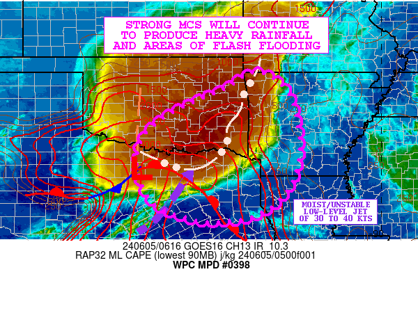
SUMMARY...A strong MCS dropping southeast once again down into the
Red River Valley of the South and the Arklatex region will favor
heavy rainfall and a renewed threat of flash flooding.

DISCUSSION...A very-cold topped MCS continues to advance
southeastward down across central and southeast OK and is quickly
advancing into north-central to northeast TX. The convective mass
is riding down along the eastern flank of a strong instability
gradient, with the activity being strongly supported by a moist
and very unstable southwest low-level jet of 30 to 40 kts which is
overrunning a warm front across north-central TX.

MLCAPE values across north-central TX just ahead of the Red River
Valley convective bow are on the order of 4000 to 5000 J/kg and
indicative of an extremely unstable airmass pooled up across the
region. This instability coupled with PWs of 1.5 to 1.75 inches
will favor very heavy rainfall rates which may reach as high as
1.5 inches in 30 minutes.

Generally the rather rapid forward propagation of the MCS should
tend to mitigate the overall storm potential somewhat, but there
are additional embedded showers and thunderstorms with heavy
rainfall rates in behind the initial convective bow, and this will
support locally excessive totals. The 00Z HREF guidance supports a
general swath of 2 to 4 inch rainfall potential dropping down
through southeast OK and into portions of north-central to
northeast TX going through 12Z. However, recent runs of the HRRR
guidance are a tad wetter, and support isolated 5 inch amounts
over parts of north-central TX which is also a little west of the
00Z HREF consensus.

Given the wet/saturated soil conditions and elevated streamflows
across the region from multiple days of repeating heavy rainfall
events, these additional MCS-driven rains overnight and into the
early morning hours will support areas of flash flooding. The
flash flood threat will likely tend extend into areas of
west-central to southwest AR and far northwest LA later this
morning, but in the near-term should be maximized in south-central
to southeast OK and north-central to northeast TX.

Orrison

ATTN...WFO...FWD...HGX...LZK...OUN...SHV...TSA...

ATTN...RFC...ABRFC...LMRFC...WGRFC...NWC...

LAT...LON   36499416 35739310 33589276 32029361 31499546
            31899732 32759803 33759817 34439788 35109704
            35499625 35949521
Download in GIS format: Shapefile
| KML
Note: This service is not intended for secure transactions such as banking, social media, email, or purchasing. Use at your own risk. We assume no liability whatsoever for broken pages.
Alternative Proxies: