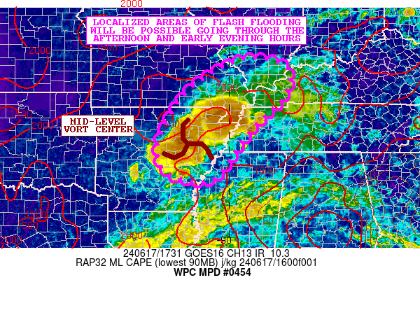
Mesoscale Precipitation Discussion 0454
NWS Weather Prediction Center College Park MD
137 PM EDT Mon Jun 17 2024

Areas affected...Portions of the Mid-South into the Lower OH
Valley

Concerning...Heavy rainfall...Flash flooding possible

Valid 171735Z - 172335Z

SUMMARY...Occasional training of showers and thunderstorms may
result in some localized areas of flash flooding heading through
the afternoon and early evening hours.

DISCUSSION...A mid-level vort center advancing northward around
the western periphery of the subtropical ridge over the Eastern
U.S. will be impacting portions of the Mid-South and Lower OH
Valley going through the afternoon and early evening hours with at
least broken coverage of heavy showers and thunderstorms.

GOES-E IR satellite imagery along with radar has been already
showing expansion of convection across areas of central to
northeast AR and through the MO Bootheel as stronger diurnal
heating/boundary layer destabilization occurs in concert with some
uptick in low-level moisture convergence near the mid-level vort
center. Over the next few hours, expect more areas of southeast MO
and potentially as far northeast as southern IL and western KY to
get into the coverage of broken areas of convection.

MLCAPE values of 1500 to 2500 J/kg are in place, and with PWs of
locally over 2 inches which will favor high rainfall rate
potential. The CIRA-ALPW shows notably concentrated moisture in
the 850/500 mb layer which should help yield enhanced rainfall
efficiency for locally extreme rainfall rates given some of the
forcing and instability situated near the vort center.

Some rainfall rates may reach 2.0 to 2.5 inches/hour and there
will be some localized concerns for cell-training with potentially
some north/south oriented bands of convection. Radar does
currently show evidence of this across areas of central AR.

The latest HRRR guidance suggests some isolated rainfall totals
potentially reach 3 to 5+ inches going through early this evening,
and this should favor at least localized concerns for flash
flooding.

Orrison

ATTN...WFO...JAN...LSX...LZK...MEG...PAH...SGF...

ATTN...RFC...ABRFC...LMRFC...NCRFC...OHRFC...NWC...

LAT...LON   38148913 37848811 36998810 35608940 34219041
            34049127 34429218 35289235 36449184 37199119
            37889012
Download in GIS format: Shapefile
| KML
Note: This service is not intended for secure transactions such as banking, social media, email, or purchasing. Use at your own risk. We assume no liability whatsoever for broken pages.
Alternative Proxies: