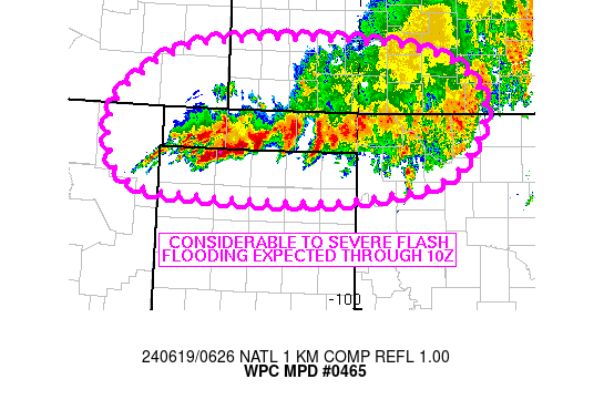
Mesoscale Precipitation Discussion 0465
NWS Weather Prediction Center College Park MD
228 AM EDT Wed Jun 19 2024

Areas affected...OK Panhandle and immediate vicinity

Concerning...Heavy rainfall...Flash flooding likely

Valid 190627Z - 191030Z

SUMMARY...Areas of considerable flash flooding area likely to
continue for The OK Panhandle and surrounding locations, some of
which could bring severe to life threatening impacts. A slow
moving area of heavy rain will continue to produce 2 to 3+ in/hr
rainfall rates for another few hours with an additional 4-8 inches
possible through 10Z.

DISCUSSION...Radar imagery at over the southern High Plains at 06Z
showed a slow moving axis of thunderstorms entering the northern
TX Panhandle from the north. Movement of heavy rain has averaged
5-10 kt to the south over the past 4 hours but movement appears to
have slowed over the past hour and some upstream development has
continued to manifest into far northeastern NM as a dryline
retreats westward through eastern NM. 40-50 kt of southerly flow
at 850 mb was overrunning a quasi-stationary front and convective
outflow, with the outflow boundary located just south of ongoing
convection in the northern TX Panhandle. Highly anomalous moisture
near the climatological max for this region of the country and
1000-2000 J/kg MUCAPE (per SPC mesoanalysis data) was fueling
observed rainfall rates of 2-3 in/hr with 3 to 8 inches of rain
estimated via MRMS over the past 7 hours from Stevens and Seward
counties in southwestern KS into Texas and Beaver counties in the
OK Panhandle.

With an established cold pool located just south of the ongoing
convection (located within the southern portion of the
northernmost row of counties in the northern TX Panhandle) only
edging slowly to the south, low level southerly flow will continue
to overrun the boundary allowing for continued thunderstorm
development, despite 5-10 kt of forecast weakening through 10Z.
Infrared satellite trends have shown new updrafts propagating
toward the WSW and these trends are expected to continue over the
next 1-2 hours but with slow to stationary movement of heavy
rainfall echoes in the OK Panhandle. Additional elevated
development of convection will also be possible farther north into
southwestern KS toward 12Z, along a strengthening convergence axis
aloft, although this additional development is not certain.
Localized rainfall rates of 2 to 3+ in/hr are expected to continue
in the short term with an additional 4 to 8 inches of rain
possible through 10Z over the OK Panhandle and adjacent locations.
These rains will continue to have significant flash flood impacts
for the region with life-threatening flash flooding possible.

Otto

ATTN...WFO...ABQ...AMA...DDC...ICT...OUN...PUB...

ATTN...RFC...ABRFC...NWC...

LAT...LON   37810224 37799908 37219808 36489831 36109891
            35900049 35920238 36040346 36530382 37230356
Download in GIS format: Shapefile
| KML
Note: This service is not intended for secure transactions such as banking, social media, email, or purchasing. Use at your own risk. We assume no liability whatsoever for broken pages.
Alternative Proxies: