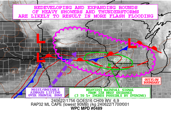
Mesoscale Precipitation Discussion 0489
NWS Weather Prediction Center College Park MD
200 PM EDT Sat Jun 22 2024

Areas affected...Northern and Eastern IA...Southern MN...Southern
WI...Northern IL

Concerning...Heavy rainfall...Flash flooding likely

Valid 221800Z - 230000Z

SUMMARY...Additional rounds of heavy showers and thunderstorms are
expected to develop and expand in coverage this afternoon and
going into the evening hours. Sensitive antecedent conditions with
high streamflows and wet/saturated soils will favor a likelihood
of flash flooding.

DISCUSSION...GOES-E WV suite shows a strong shortwave trough
advancing off to the east across the northern Plains which will
proceed downstream toward the Upper Midwest this afternoon.
Favorable DPVA associated with this coupled with interaction with
a quasi-stationary front draped from far eastern NE through
northern IA and southwest WI will set the stage for additional
rounds of heavy showers and thunderstorms going through the
afternoon hours.

Radar imagery already depicts a broken area of elevated showers
and thunderstorms advancing into southwest MN, and as the
approaching energy begins to interact with an increasingly
unstable airmass reloading along the front just down to the south
and east, there will be the initiation of new rounds of convection.

MLCAPE values across northern IA in close proximity to the front
have risen to 1500+ J/kg over the last couple of hours, and
additional boundary layer destabilization is expected with more
diabatic heating over the next few hours. This coupled with a belt
of stronger effective bulk shear values of 40 to 50 kts and
southwest low-level flow overrunning the front should help to
initiate new rounds of convection in a general west to east
fashion through the mid to late-afternoon hours across northern IA
and eventually spreading into southern WI and northern IL.
Proximity of a pre-existing outflow boundary over northeast IA
through northern IL may also act as a catalyst for convection to
initiate and focus by late this afternoon.

High PWs of 1.75 to locally a little over 2 inches are pooled
across the region based on the latest GPS-derived data, and the
CIRA-ALPW data shows highly concentrated moisture in the warm
850/500 mb portion of the cloud-bearing layer. This will yield
very efficient rainfall processes as convection initiates and
expands in coverage with rainfall rates that may reach 2.5+
inches/hour.

The 12Z HREF guidance suggests as much as 3 to 5 inches of rain
may focus by early this evening across areas of northeast IA into
southwest WI where there will also be concerns for some
cell-training. Given the high rainfall rates, isolated heavier
totals cannot be ruled out. Lesser amounts should generally be
noted across southern MN, but with the elevated convection here,
some localized additional 1 to 3 inch amounts will be possible.

Given the sensitive wet/saturated soil conditions and high
streamflows in general, these additional rains are likely to
result in areas of flash flooding. Urban flash flooding will also
become a concern by this evening at least locally.

Orrison

ATTN...WFO...ARX...DMX...DVN...FSD...GRB...LOT...MKX...MPX...

ATTN...RFC...MBRFC...NCRFC...NWC...

LAT...LON   45319425 45169288 44729158 44309041 43798817
            43118740 42168753 41738823 41568977 41729136
            42219341 43249504 44739534
Download in GIS format: Shapefile
| KML
Note: This service is not intended for secure transactions such as banking, social media, email, or purchasing. Use at your own risk. We assume no liability whatsoever for broken pages.
Alternative Proxies: