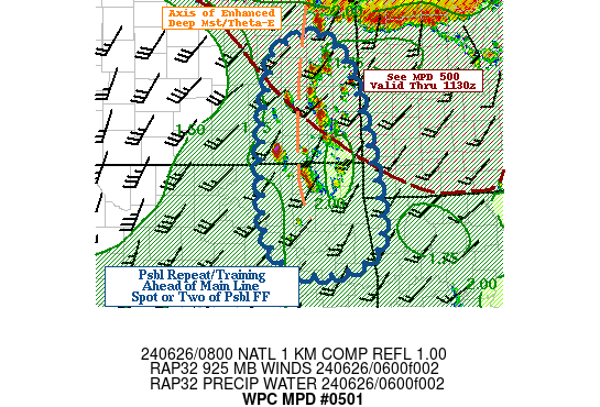
Mesoscale Precipitation Discussion 0501
NWS Weather Prediction Center College Park MD
403 AM EDT Wed Jun 26 2024

Areas affected...Southeast Kansas...Northeast Oklahoma...

Concerning...Heavy rainfall...Flash flooding possible

Valid 260800Z - 261200Z

SUMMARY...Slow moving, potentially training elevated thunderstorms
ahead of main line may pre-soak grounds (1.5-2.5") before main
line adds additional 1-2" for spots of 2-3.5" and possible
localized flash flooding before morning

DISCUSSION...GOES-E 10.3um loop shows a zone of scattered TCu
building to scattered CBs with tops already reaching -55C with
increasing trend in GLM/NLDN lightning indicating increasing vigor
to the updrafts.  The agitated cells are aligned north-south on an
enhanced theta-E boundary generally in the 354-360K range,
resulting in an extension of the larger unstable air mass; but
slightly differentiated the main warm sector (2500-3000 J/kg of
CAPE).  VWP shows slow veering in the 925-850mb layer with
40-45kts increasing orthogonal deep layer convergence along this
axis.  The gradient of slightly drier air to the WSW, is
steepening isentropic plane for greater vertical ascent to break
these pre-cursory cells out.  Deep layer moisture is at or just
below 2" and given flux into the updrafts, there will be some
capability for efficient rainfall production and moisture mass
loading for rates of 2"/hr along with some hail production. Given
KDP ratios, likely small enough to add to flooding risk with
clogged culverts, rather than robbing moisture with larger more
wide spread stones.

Cell motions are going to be slowed by approach of stronger
high-falls and pressure-fall influences further north and with
southward propagation vectors, scattered cells may repeat/train
locally as they increase in number.  The combination of slow
motions and rates, may allow for localized 2-3" totals to occur
pre-cursory to the main squall line.  Dry ground conditions with
higher FFG over 2.5-3"/hr and 3-4"/3hr the probability of
exceedance is going to be low, especially into Northeast OK where
relative soil moisture is in the 30-40% range, with 40-55% a bit
further north.  Still, these cells could pre-soak the ground and
reduce infiltration for the stronger/heavy and more intense burst
expected with the main squall line later this morning.  As such,
flash flooding is only considered possible and widely scattered
through 12z.

Gallina

ATTN...WFO...EAX...ICT...SGF...TOP...TSA...

ATTN...RFC...ABRFC...MBRFC...NWC...

LAT...LON   38719532 38269482 36879445 35829442 35489539
            35859617 36819631 37549626 38229613 38539600
Download in GIS format: Shapefile
| KML
Note: This service is not intended for secure transactions such as banking, social media, email, or purchasing. Use at your own risk. We assume no liability whatsoever for broken pages.
Alternative Proxies: