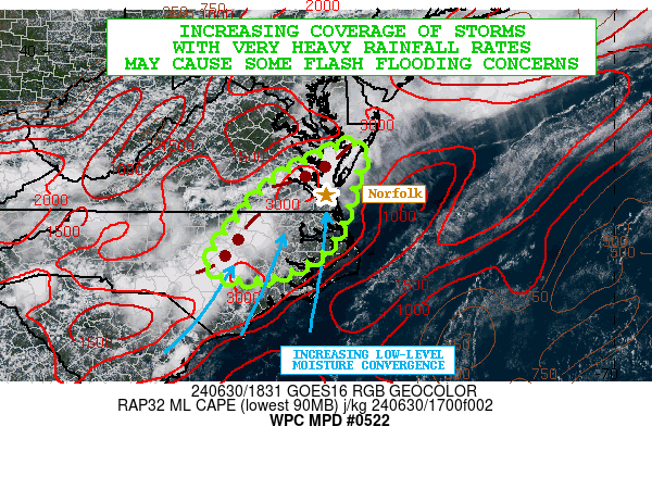
Mesoscale Precipitation Discussion 0522
NWS Weather Prediction Center College Park MD
242 PM EDT Sun Jun 30 2024

Areas affected...Lower Delmarva...Southeast VA...Northeast NC

Concerning...Heavy rainfall...Flash flooding possible

Valid 301841Z - 010041Z

SUMMARY...An increase in the coverage of very heavy showers and
thunderstorms can be expected over the next few hours across areas
of the lower Delmarva down through southeast VA including the
Hampton Roads vicinity, and also northeast NC. Locally extreme
rainfall rates coupled with some urban sensitivities will foster a
threat for flash flooding going into the early evening hours.

DISCUSSION...A look at the latest GOES-E visible satellite imagery
along with radar shows gradually increasing coverage of heavy
shower and thunderstorm activity across areas of southeast VA and
northeast NC. Visible satellite trends show an increasingly
expansive CU/TCU field across these areas out ahead of the current
activity, and the boundary layer is very unstable with MLCAPE
values of 3000 J/kg in place. Microwave data and morning RAOB
soundings confirm a deeply tropical airmass with high PWS reaching
as high as 2.25 inches.

Increasingly convergent low-level flow over the next few hours is
expected across northeast NC through especially southeast VA
including the Hampton Roads area. This combined with the very
strong thermodynamic environment and some modest shear aloft
should favor a notable expansion of convection over the next few
hours, with concerns locally for cell-mergers and some
cell-training given the orientation of the convection with the
deeper layer southwest flow aloft.

Rainfall rates are likely to reach 2.0 to 2.5 inches/hour with the
stronger cells, and the 12Z HREF consensus support some potential
for rainfall amounts to reach 3 to 5 inches going through 00Z (8pm
EDT). The heaviest rains are likely to be over southeast VA where
the multi-model hires consensus supports the strongest low-level
moisture convergence. However, adjacent areas of northeast NC and
the lower Delmarva may also seem locally heavy totals.

Some flash flooding will be possible given the high rainfall rates
and also notable concerns for impacts to the urban areas,
including the I-64 corridor from Williamsburg down through Norfolk
and Virginia Beach.

Orrison

ATTN...WFO...AKQ...MHX...RAH...

ATTN...RFC...MARFC...SERFC...NWC...

LAT...LON   37977577 37837536 37397557 36787572 36287587
            35667633 35207727 35137815 35417871 36207823
            37257723
Download in GIS format: Shapefile
| KML
Note: This service is not intended for secure transactions such as banking, social media, email, or purchasing. Use at your own risk. We assume no liability whatsoever for broken pages.
Alternative Proxies: