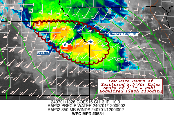
Mesoscale Precipitation Discussion 0531
NWS Weather Prediction Center College Park MD
928 AM EDT Mon Jul 01 2024

Areas affected...Northeastern Kansas...Parts of Adj. Northwest
Missouri...

Concerning...Heavy rainfall...Flash flooding possible

Valid 011330Z - 011700Z

SUMMARY...Stronger, efficient rainfall producing cells are on a
downward trend, but spots of 2-3" quick totals may occur over the
next few hours before fully dissipating.  As such, a spot or two
of localized flash flooding are possible, especially if cells
track through urban centers.

DISCUSSION...Regional RADAR depicts a broad area of warm advective
showers and widely scattered embedded thunderstorms across eastern
Nebraska into northeast Kansas, sliding into SW IA, W MO.  There
appeared to be two waves, a well elevated and boundary layer
elevated band of cells, but as lapse rates and distance from
deeper theta-E/moisture pool over the central Plains rapidly
reduces across IA/MO; so have the cells... with the first wave
already becoming very stratiform in nature.

However, the upwind wave still has solid 20-25kts of southwesterly
850-700mb ascent per TWX/EAX/MCI VWP orthogonal to remaining
instability gradient and deep moisture axis across the region.  As
such, upstream convergence has been strong enough to maintain or
even develop a few cells in the last few hours across NE KS.  The
southern most with significant rainfall rates (over 4"/hr in N
Lyon county) and latent heat release has formed a weak MCV and is
aiding flux convergence to the related cells to maintain 2-2.5"/hr
rates...given deep layer pool of 2.25" TPW, which is near record
for the date/time.  While rates are likely to decrease with
reducing WAA flow and distance from instability axis, spots of
2-3" will remain possible for the next few hours, especially with
favorable back-building, flanking line development in a weakening
inflow environment; but will be widely scattered to those
remaining deeper convective elements from Marshall, to Jackson to
Douglas county.  If these cells intersect with urban centers,
especially between Topeka and Kansas City metro, a localized
incident or two of flash flooding will still be possible through
16-17z.

Gallina

ATTN...WFO...EAX...TOP...

ATTN...RFC...MBRFC...NWC...

LAT...LON   39979580 39889498 39459420 38889390 38469421
            38349474 38559548 39009603 39279637 39859688
            39959625
Download in GIS format: Shapefile
| KML
Note: This service is not intended for secure transactions such as banking, social media, email, or purchasing. Use at your own risk. We assume no liability whatsoever for broken pages.
Alternative Proxies: