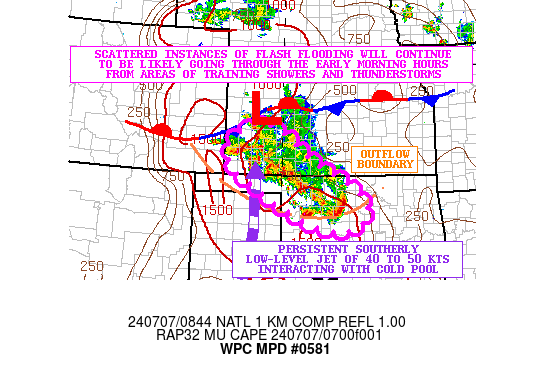
Mesoscale Precipitation Discussion 0581
NWS Weather Prediction Center College Park MD
448 AM EDT Sun Jul 07 2024

Areas affected...Southwest KS...Northwest to Central OK

Concerning...Heavy rainfall...Flash flooding likely

Valid 070845Z - 071400Z

SUMMARY...Ongoing areas of heavy showers and thunderstorms will
continue to locally backbuild and train over the same area going
into the early morning hours. Some additional expansion and
increase in the threat of flash flooding is expected over the next
few hours, with the greatest concerns continuing over southwest
KS, but with the threat increasing over northwest OK.

DISCUSSION...Radar imagery continues to show multiple bands of
locally backbuilding and training showers and thunderstorms, with
the activity impacting southwest KS down through northwest OK. The
leading edge of the convection has been tending to bow off to the
southeast in a more progressive nature and is beginning to edge
into central OK. However, with exception of this leading
convective bow situated in between KEND and KJWG, much of the
trailing convection is elevated and has been concentrated in a
northwest/southeast fashion over top of a well-defined cold pool
with a strong low-level jet interacting with it.

This southerly low-level jet is locally on the order of 40 to 50
kts and is favoring enhanced isentropic ascent along with rather
strong moisture transport. MUCAPE values remain relatively modest
with values of 500 to 1000+ J/kg in vicinity of the cold pool, but
there continues to be the arrival of shortwave energy from the
central Rockies which is yielding deeper layer ascent/forcing to
help compensate for the lack of stronger thermodynamics.

Additional backbuilding and training of heavy showers and
thunderstorms can be expected going into the early morning hours,
and rainfall rates with the stronger storms will continue to be on
the order of 1 to 2 inches/hour. Some additional storm totals
going through the early morning will be 2 to 4 inches with
isolated heavier amounts.

This will be on top of some areas that have already seen locally a
few inches of rain and corresponding flash flooding overnight.
Therefore, areas of flash flooding will be likely going through
the early morning hours, and especially over southwest KS.
However, the threat may expand and increase over areas of
northwest OK as cell-training concerns eventually shift from
southwest KS into northwest OK over the next few hours.

Orrison

ATTN...WFO...AMA...DDC...GLD...ICT...OUN...

ATTN...RFC...ABRFC...NWC...

LAT...LON   38370107 38300032 38059980 37419895 36969809
            36589740 36109704 35509745 35549868 36140005
            36470065 36790118 37250177 37850188
Download in GIS format: Shapefile
| KML
Note: This service is not intended for secure transactions such as banking, social media, email, or purchasing. Use at your own risk. We assume no liability whatsoever for broken pages.
Alternative Proxies: