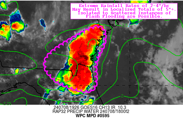
Mesoscale Precipitation Discussion 0595
NWS Weather Prediction Center College Park MD
330 PM EDT Mon Jul 08 2024

Areas affected...northeast FL...southeast GA

Concerning...Heavy rainfall...Flash flooding possible

Valid 081930Z - 090130Z

Summary...Extreme rainfall rates of 2-4"/hr may result in
localized totals of 5"+. Isolated to scattered instances of flash
flooding are possible.

Discussion...Deep convection is firing along the sea breeze
circulation this afternoon over southeast GA and northeast FL,
evident via GOES-East infrared imagery with impressively cold
cloud tops of -80deg C. Given near record levels of tropospheric
moisture content (precipitable water values of 2.3-2.6 inches)
with very slow storm motions (850-300 mb mean wind of 5 kts or
less), extreme rainfall rates of 2-4"/hr are being realized with
the strongest updrafts. While effective bulk shear of less than 20
kts should generally prevent meaningful organization and limit
storm longevity, a tropical upper-tropospheric trough (TUTT) to
the east is allowing for some upper-level divergence on the
western periphery of a ~70 kt sub-tropical jet streak. This subtle
feature (combined with the aforementioned tropical-like
tropospheric moisture) could allow for some repeating and
backbuilding of these impressive rates. This is also evidenced by
HREF 40-km neighborhood exceedance probabilities of 30-50% for the
5" threshold, which is near or above the corresponding (6-hr)
Flash Flood guidance (generally 4.0-5.0"). As a result, isolated
to scattered instances of flash flooding are possible (with
particular concern for low-lying, urbanized terrain).

Churchill

ATTN...WFO...CHS...JAX...TAE...

ATTN...RFC...SERFC...NWC...

LAT...LON   32198133 31748099 30898133 29838146 30218282
            31088313
Download in GIS format: Shapefile
| KML
Note: This service is not intended for secure transactions such as banking, social media, email, or purchasing. Use at your own risk. We assume no liability whatsoever for broken pages.
Alternative Proxies: