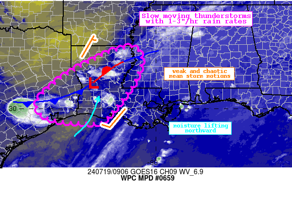
Mesoscale Precipitation Discussion 0659
NWS Weather Prediction Center College Park MD
513 AM EDT Fri Jul 19 2024

Areas affected...eastern Texas, much of western and central
Louisiana

Concerning...Heavy rainfall...Flash flooding possible

Valid 190912Z - 191400Z

Summary...Slow moving thunderstorms with 1-3"/hr rain rates will
expand and continue through the morning. These storms could
produce 2-3" of rainfall with locally higher amounts near 5"
possible. This may create instances of flash flooding.

Discussion...The regional radar imagery early this morning shows a
slow expansion of showers and thunderstorms developing from the
Upper Texas Coast and parts of eastern Texas through much of
central and northern Louisiana. These storms are moving very
slowly in the vicinity of a wave of low pressure, with a vorticity
maxima clearly evident on GOES-E WV imagery. An upper level trough
axis positioned nearly overhead is resulting in dual, but modest,
jet streaks in a favorably coupled position, helping to enhance
ascent into robust thermodynamics characterized by PWs of 2-2.2
inches overlapped with a tongue of MUCAPE exceeding 1000 J/kg.
Rain rates within this convection have been estimated by KPOE
WSR-88D to be as high as 2"/hr, despite generally modest
reflectivity. This is suggestive of efficient warm rain processes,
which are also supported by model soundings depicting 14,000 ft of
warm cloud depths with near moist-adiabatic lapse rates throughout.

The CAMs are in modest agreement for the next several hours, but
appear to be under-doing the current convective coverage, and may
be too fast to erode activity. Modest inflow off the Gulf of
Mexico noted by 850mb winds of just 10-15 kts will be sufficient
to continue to draw the more impressive thermodynamics northward
to support continued convection, especially within the axis of
strongest ascent in the vicinity of the mid-level impulse and
along the surface low/front. In the weak flow, mean 850-300mb
winds are just 5-10 kts, with direction varying depending on
position relative to the surface low. Mean propagation vectors are
additionally very weak at just 5-10 kts, and with minimal bulk
shear, this suggests generally pulse-type convection with very
slow storm motions. Although storm lifespans may be modest except
along any local convergent boundaries (front, cell mergers), the
environment will support rainfall rates which both the HREF and
REFS indicate have a 15-25% chance of exceeding 2"/hr, further
reflected by HRRR 15-min rainfall accumulations reaching 0.75" in
a few locations. The slow drift of these rain rates despite the
pulse nature could produce rainfall of 2-3", with isolated totals
up to 5" possible.

Most of this region has been dry the past 7 days noted by AHPS
rainfall that is just 25-50% of normal, allowing FFG to be
elevated at 3"/3hrs. Despite that, the very slow storm motions and
efficient rainfall rates could still overwhelm these soils, and
HREF 3-hr FFG exceedance probabilities reach 15%. This indicates
at least an isolated flash flooding risk through the morning.

Weiss

ATTN...WFO...HGX...JAN...LCH...LIX...SHV...

ATTN...RFC...LMRFC...WGRFC...NWC...

LAT...LON   32939099 32409069 32009076 31049121 29709222
            29359266 29369348 29399415 29489487 29719542
            30179571 30669544 31639426 32529258 32829176
Download in GIS format: Shapefile
| KML
Note: This service is not intended for secure transactions such as banking, social media, email, or purchasing. Use at your own risk. We assume no liability whatsoever for broken pages.
Alternative Proxies: