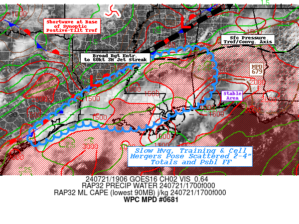
Mesoscale Precipitation Discussion 0681
NWS Weather Prediction Center College Park MD
315 PM EDT Sun Jul 21 2024

Areas affected...Southern LA...Southern MS...Southwest AL...Far
Southast TX...

Concerning...Heavy rainfall...Flash flooding possible

Valid 211915Z - 220045Z

SUMMARY...Slow moving, efficient cells likely merging into a
common axis across the area of concern with a favorable training
profile, to locally enhanced rainfall totals.   Spots of 3-4" may
result in localized flash flooding through evening.

DISCUSSION...19z surface analysis denotes a strong stationary
front from central TN across NE MS to central LA and hugging the
Upper Texas Gulf Coast; southeast of which and deep rich moisture
pool exists through depth with 2-2.25" values. Though northern AL
is split slightly that the surface boundary is north and the
moisture is a tad shallower, there is a weak pressure reflection
of the moisture gradient and active convection has already
developed along it (please see MPD 679 for details).  The based of
the larger scale positive tilt trough exists over central AR and
is driving this slight split while further aloft, 3H winds
accelerate around the base providing right entrance ascent to this
50-60kt jet as far back as central LA.

However, in the low levels winds are weak to modest (less than
15kts) and not highly convergent from a synoptic position.
However, surface convergence along the boundary and peak heating
have been sufficient for breaking out some thunderstorms along the
front, particularly near Jackson, MS where the intersection of the
pressure trough exists.  Morning convection along/just offshore
has helped tighten an insolation/heating gradient as well as
providing outflow for a northward propagation of weaker updraft
cells (though still highly efficient given that 2-2.25" total
moisture through depth).  As such an axis of unstable air
(1500-2500 J/kg MLCAPE) exists between the two boundaries across
SE TX, south-central LA, southern MS.  Hi-Res CAMs have been
consistent in developing convection across this unstable axis and
the mergers/confluence aligns favorably with deep layer steering
of 5-15kts from the southwest.   A 500-1000 thickness trough also
exists through the axis, so weak propagation vectors will also
support slow moving, slightly converging and potentially training
cells through the axis.   Cells upstream will have less areal
coverage/narrower axis across SE TX, so potential for maintaining
cells longer is less likely but spots of 2-4" are likely and may
induce localized flash flooding/rapid inundation issues through
evening.  Downstream, broader unstable air mass will slowly
converge across SE MS/SW AL with greater potential for
spots/coverage of 2-4" and maybe an isolated 5" total by late
evening.  The area has better infiltration than lower FFG further
north, so all considered, scattered incidents are possible.


Gallina

ATTN...WFO...BMX...HGX...JAN...LCH...LIX...MOB...SHV...

ATTN...RFC...LMRFC...SERFC...WGRFC...NWC...

LAT...LON   33058822 32838769 32098745 31068763 30518825
            30118940 29719012 29459087 29399174 29489253
            29679346 29489406 28719565 28849606 29279588
            30019481 31149324 31869187 32609033 32948917
Download in GIS format: Shapefile
| KML
Note: This service is not intended for secure transactions such as banking, social media, email, or purchasing. Use at your own risk. We assume no liability whatsoever for broken pages.
Alternative Proxies: