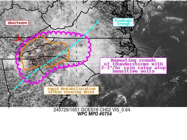
Mesoscale Precipitation Discussion 0754
NWS Weather Prediction Center College Park MD
1256 PM EDT Mon Jul 29 2024

Areas affected...Southern Appalachians into the Piedmont

Concerning...Heavy rainfall...Flash flooding possible

Valid 291655Z - 292255Z

Summary...Showers and thunderstorms should rapidly develop and
intensify downstream of a shortwave this afternoon. Rainfall rates
of 2-3"/hr are likely, which through repeated rounds could cause
2-4" of rainfall with locally higher amounts. Flash flooding is
possible.

Discussion...The GOES-E visible satellite imagery this afternoon
indicates that cloud cover associated with morning rainfall is
advecting into the Coastal Plain of the Carolinas, leaving clear
skies in its wake. Upstream of this clearing, a shortwave is noted
on WV imagery pivoting into eastern TN while at the same time the
Piedmont Trough becomes established across the region. The
combination of ascent downstream of this shortwave, convergence
along the surface trough, and modest thickness diffluence noted in
700-500mb RAP fields suggests ascent will steadily increase the
next several hours. This ascent will work into a region primed for
heavy rain producing thunderstorms due to thermodynamics
characterized by PWs of around 2 inches and SBCAPE that has
climbed approximately 1000 J/kg in the last 3 hours to be
1500-2500 J/kg.

Deepening Cu already noted in the clear areas is collocated with a
slow rise in Lightning-cast probabilities, further indicative of
the intensifying updrafts. This is also noted in recent radar
returns from KGSP, and although rain rates are currently modest,
both the HREF and REFS neighborhood probabilities reach 30-50% for
2"/hr in the next few hours. Additionally, the HRRR 15-min
rainfall accumulations peak around 1" in parts of the area,
suggesting brief rainfall rates of up to 4"/hr are possible. These
intense rain rates will offset the anticipated generally
progressive motions of cells today as 0-6km mean winds remain out
of the west at 15-20kts. Corfidi vectors are a bit slower and
aligned to the mean wind, so short duration training is possible,
but in general the flash flood risk appears driven primarily by
the potential for multiple rounds of storms in many areas. This is
due to the anticipated expansion in coverage progged by many
high-res CAMs simulated reflectivity, which is supported by the
persistent ascent into the favorable thermodynamics. Where several
rounds of intense rainfall do occur, some locations could receive
2-4" of rainfall, and the HREF indicates a 10-20% chance for
locally as much as 5".

The Southern Appalachians and surrounding Piedmont have
experienced significant rain recently, noted by AHPS 7-day
rainfall departures that are generally 150-300% of normal. This
has caused a reduction in FFG to around 2-2.5"/3hrs, and even as
low as just 1"/3hrs in eastern TN. HREF FFG exceedance
probabilities peak above 30%, providing additional confidence to
scattered flash flood instances today. While the greatest risk
should be focused atop sensitive terrain features or urban areas,
any location that receives several rounds of heavy rainfall this
aftn could experience flash flooding.


Weiss

ATTN...WFO...CAE...FFC...GSP...ILM...MRX...RAH...RNK...

ATTN...RFC...LMRFC...OHRFC...SERFC...NWC...

LAT...LON   36878164 36808046 36738001 36477920 35377916
            34777966 34458147 34108216 33588265 33328292
            33348349 33578387 34008408 34618432 35218437
            36018397 36418343 36768271
Download in GIS format: Shapefile
| KML
Note: This service is not intended for secure transactions such as banking, social media, email, or purchasing. Use at your own risk. We assume no liability whatsoever for broken pages.
Alternative Proxies: