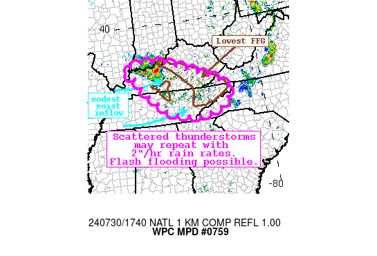
Mesoscale Precipitation Discussion 0759
NWS Weather Prediction Center College Park MD
143 PM EDT Tue Jul 30 2024

Areas affected...Kentucky, Tennessee

Concerning...Heavy rainfall...Flash flooding possible

Valid 301742Z - 302330Z

Summary...A combination of increasing diurnal thunderstorms and a
fast moving MCS will produce axes of heavy rain through the
afternoon. Rainfall rates of 1-3"/hr are possible, which could
produce rainfall of 2-3" with locally higher amounts. Instances of
flash flooding may result.

Discussion...The regional radar mosaic this afternoon indicates an
MCS downstream of a convectively enhanced shortwave diving rapidly
across southern IN into western KY. Rainfall rates immediately
downstream of this MCS have been estimated via KLVX as high as
1.5"/hr, but motion has been progressive. Farther downstream,
additional convective development has begun as far east as the
Cumberland Plateau. This more typical diurnal development is
occurring in a favorable pre-convective environment characterized
by PWs of 1.7 to 2.0 inches overlapping MLCAPE of 2000-3000 J/kg.
850mb inflow of around 20 kts measured by regional VWPs is locally
backing in response to the incoming shortwave, but is generally
originating from the higher CAPE/PW to advect even greater
thermodynamics into the region.

The high-res CAMs are really struggling to resolve ongoing
activity due to poor handling of the multiple convective
shortwaves embedded within the otherwise broad NW flow. The ARW is
at least suggesting the potential increase in convective coverage,
but is missing the MCS, while the other high res models have very
little semblance of the current activity. This creates a
lower-than-typical confidence forecast. However, with robust
thermodynamic advection persisting, the environment is likely to
remain primed to support intense thunderstorms, and despite the
model disagreement, both HREF and REFS 2"/hr rain rate
probabilities reach 10-20%, with locally higher rain rates
possible as forecast by isolated HRRR 15-min rainfall
accumulations as high as 0.75". Storms should remain progressive
on 0-6km mean winds of 20-30 kts, limiting the duration of these
heavy rain rates, but plentiful 0-6km bulk shear will help
organize convection (or maintain the ongoing MCS) to support
either repeating rounds or brief training of cells. More
importantly, convection increasing downstream of the MCS will help
prime the soils with heavy rain before the MCS sweeps through,
resulting in locally as much as 3+" of rain, enhancing the flash
flood risk.

The antecedent conditions across KY and TN are vulnerable to rapid
runoff, increasing the otherwise modest flash flood risk. 7-day
rainfall according to AHPS has been as much as 300% of normal
(highest in TN) leading to 3-hr FFG as low as 1-1.5". While any
individual fast moving cell probably won't result in flash
flooding, where multiple rounds can occur across the more
sensitive soils or terrain features, instances of flash flooding
could result.


Weiss

ATTN...WFO...GSP...JKL...LMK...MRX...OHX...PAH...

ATTN...RFC...LMRFC...OHRFC...NWC...

LAT...LON   38138671 38028577 37518421 36618223 36188208
            35678249 35428302 35288378 35218403 35548575
            36718719 37458773 37928844 38108767
Download in GIS format: Shapefile
| KML
Note: This service is not intended for secure transactions such as banking, social media, email, or purchasing. Use at your own risk. We assume no liability whatsoever for broken pages.
Alternative Proxies: