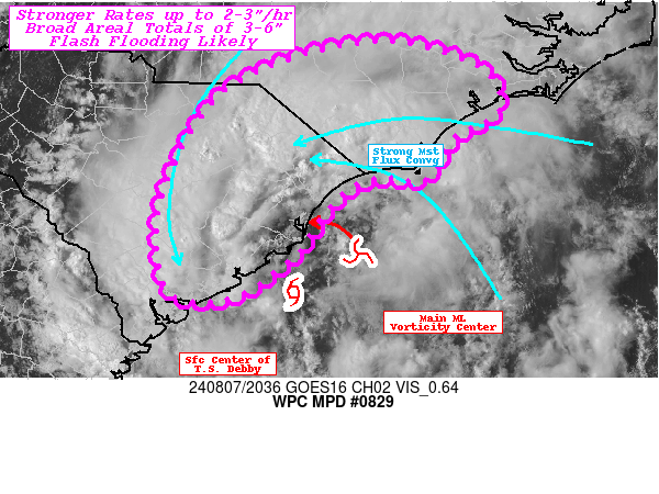
Mesoscale Precipitation Discussion 0829
NWS Weather Prediction Center College Park MD
440 PM EDT Wed Aug 07 2024

Areas affected...Eastern South Carolina...Southeastern North
Carolina...

Concerning...Heavy rainfall...Flash flooding likely

Valid 072045Z - 080245Z

SUMMARY...T.S. Debby.  Increasing convective activity and rainfall
efficiency with rates of 2-3"/hr and totals of 3-6" through 03z.
Flash flooding will be likely.

DISCUSSION...GOES-E presentation of T.S. Debby is a fairly
symmetric if ragged donut with expanding thunderstorm activity
along the northern hemisphere of the circulation.  The center is
nearing the central SC coast with slow north-northwestward
wobbles.  However, it is the very strong mid-level vorticity
center that is providing strong downstream DPVA as it rotates
along the eastern side of the surface center.  This has backed sfc
to boundary layer flow off the southern NC coast line which is
providing very strong deep layer moisture flux convergence along
the band.  Additionally, filtered insolation though that ragged
canopy across portions of eastern SC into NC provided sufficient
surface heating in combination with the warmer/higher theta-E air
off the Gulf Stream.  As such, both areas have seen increased
1000-1500 J/kg of MLCAPE which given the saturated/moist adiabatic
lapse rates is more than sufficient for these stronger convective
elements.  Strong updrafts and numerous overshooting tops can be
seen across much of the northern hemisphere of the storm and with
convergent 35-40kts of low level flow into a weak deformation zone
axis that sharpens the change in wind direction from SSE to NNE,
provides that broader convergence to tap that unstable
environment.  10.3um EIR shows tops cooling below -65C, indicating
the stronger updraft strength.

Moisture through depth as also pooled along the eastern quadrant
of the circulation with 2.5-2.75" total PWat with sfc-850mb
accounting for 1.25-1.33" per CIRA LPW.  As such, rain rates will
become much more intense, as noted in TLX RADAR estimates.  Hourly
values of 2-3" are likely to be common through the next 2-4 hours.
 Isentropic/WAA ascent around the northwest quadrant should be
expected as well, though the rainfall magnitude will be a bit
less, it will still be at or around 2"/hr and pose equal risk for
rapid inundation flooding.  However, as the insolation instability
is exhausted, the focus and coverage should limit itself back into
the northeast quadrant along the coastal plain near the
'renewable' source of the Gulf Stream for heat and frictional
convergence will remain.

Uncertainty remains in northward propagation of the convergent
band. There are hints of propagation vectors backing into the
stronger onshore flow for back-building which would help to
deflect the band westward relative the coastline as the vorticity
center rounds the northern side of the circulation; however, there
are hi-res CAMs that also suggest a more northward (to the coast)
propagation of the band will be expected just due to stronger
easterly surface to boundary flow responding to heat
release/pressure falls near the E SC coast from the convection
itself.  Or the band equalizes and the worst case scenario of 7-9"
totals occur in proximity to the SC/NC border.   Overall,
trends/guidance supports the broadening of the overall total swath
across E SC into SE NC with broader areal coverage of 3-6" though
03z.  Either way, flash flooding, potentially significant is
considered likely through the evening into the early overnight
hours across the MPD area.

Gallina

ATTN...WFO...CAE...CHS...ILM...MHX...RAH...

ATTN...RFC...SERFC...NWC...

LAT...LON   35257850 34997735 34537712 34237761 33797788
            33817839 33647880 33247910 33007928 32587986
            32518047 32828072 33698068 34777997
Download in GIS format: Shapefile
| KML
Note: This service is not intended for secure transactions such as banking, social media, email, or purchasing. Use at your own risk. We assume no liability whatsoever for broken pages.
Alternative Proxies: