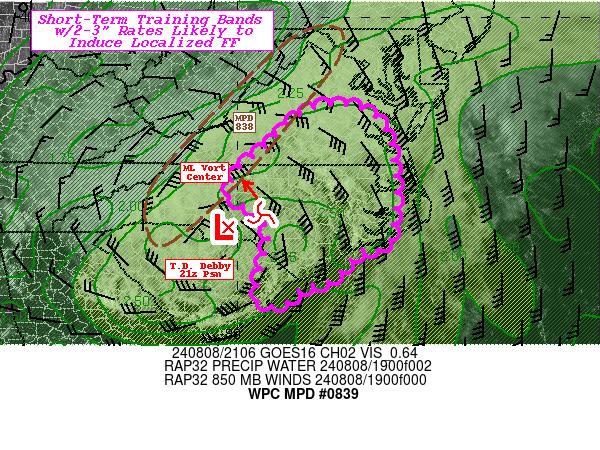
Mesoscale Precipitation Discussion 0839
NWS Weather Prediction Center College Park MD
514 PM EDT Thu Aug 08 2024

Areas affected...Southern VA...Eastern NC...Far Eastern SC...

Concerning...Heavy rainfall...Flash flooding likely

Valid 082110Z - 090230Z

SUMMARY...Narrow training bands with intense rain-rates but
duration/training will be critical for inducing flash flooding.
Training may allow for scattered streaks of 3"+ totals in 1-2
hours and likely induce localized flash flooding particularly if
intersecting with urban or already flooded areas.

DISCUSSION...T.S Debby is being downgraded to a Depression with
the 21z advisory.  However, extremely moist and conditionally
unstable environment still exists along the northeast quadrant of
the deeper circulation.  CIRA LPW and Blended TPW values (2.5")
remain at 3-4 standard anomaly from climotology still with strong
but broad south to southeasterly flow with 40-45kts of 850mb
slowly converging particularly across central VA.  Stronger core
of mid-level vorticity is rounding the eastern side of the deeper
cyclone over the next few hours providing increased DPVA for
localized backing and increased banding convergence to develop
this narrow bands.  Additionally, as the axis rotates through the
back-building nature will slowly increase to support slightly
increased duration of potential training, though the narrow nature
of the updrafts may also reduce some localized residency at any
given location as the bands slowly propagate with an eastern
component across the Piedmont of VA and Coastal Plains of NC
toward the Grand Strand of E SC.  Though nearer the vorticity
center across central NC, cell motions will be clearly different,
but still have some short-term training potential given downshear
convergence affects.  Either way, rates of 2-3"/hr are likely with
some even more intense if cells can tap greater vertical depth
with enhanced CAPE values of 1500 J/kg (noted further east as
well).  Still, probability of less than 1 hour training is likely
to result in streets of 2-3" totals with perhaps a narrow spot of
4" across the areas of concern.

NASA SPoRT 0-40cm LIS product denotes a strong differentiation
along the NC/VA border for areas of 70-90% saturation versus
30-40% in central VA.  As such, incidents of training across NC
are likely to induce flash flooding conditions (again) but more
focused/localized.  Further north in VA, this is a bit less
likely, but given 1 hr FFG are still in the range with 2.5-3"
rates, it is still very possible almost likely to induce similar
localized flash flooding conditions.

Gallina

ATTN...WFO...AKQ...ILM...MHX...RAH...RNK...

ATTN...RFC...MARFC...SERFC...NWC...

LAT...LON   37927735 37537663 36377631 34747644 34537717
            33897775 33717843 33317894 33407952 34587930
            34797923 35447946 35818018 36467993 36887941
            37807837
Download in GIS format: Shapefile
| KML
Note: This service is not intended for secure transactions such as banking, social media, email, or purchasing. Use at your own risk. We assume no liability whatsoever for broken pages.
Alternative Proxies: