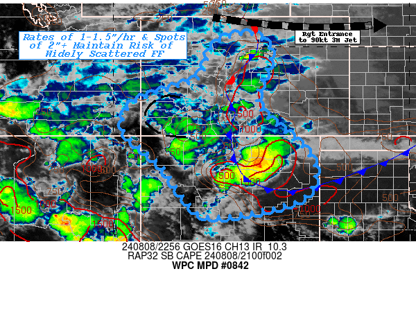
Mesoscale Precipitation Discussion 0842
NWS Weather Prediction Center College Park MD
701 PM EDT Thu Aug 08 2024

Areas affected...Northern New Mexico...Central & Southern
Colorado...Far Southeast Utah...

Concerning...Heavy rainfall...Flash flooding possible

Valid 082300Z - 090400Z

SUMMARY...Strong slow moving thunderstorms (particularly near the
surface front) continue to be capable of 1-1.5"/hr rates and
localized spots of 2"+.

DISCUSSION...Surface analysis shows the cold front continues to
press southward across the southern High Plains, though wind shift
is well in advance of the cold front, across E NM, temperatures
remain in the upper 80s/90s across the Cap Rock into central NM.
Stronger deep layer moisture exists along/just south of the CO/NM
border with up to 1" total PWAT in the higher terrain  becoming
1.25"+ in proximity to the frontal zone.  Remaining modest
unstable air west of the front and strong convergece to support
ascent with some cooler, moist inflow from the base should provide
some enhanced rainfall production for the next few hours and with
similar redevelopment locations as the front slowly presses west
against the mean flow/convergence may allow for repeating to
support spots of 2" in proximity to the foothills and may induce
localized flash flooding, especially if overlapping with burn
scars.  Stronger divergence and some modest right entrance ascent
remains strong along the CO/WY border, enough to support low to
mid-level westerly moist flow out of UT into central CO to modify
the area, should support these more scattered cells across central
CO.

Southward, a mature cluster has moved off the S Sangre de Cristo,
but also new development in proxity to the front will expand
westward through north-central NM.  Here, slightly higher moisture
and stronger cells may support a spot of 1-1.5"/hr rates and a
spot of 2"+ totals.  Flash flooding will remain possible for cells
closer to steeper terrain in central NM but there remain lower
FFGs across NE NM where recent rains have increased soil
saturation near 45-50% per NASA SPoRT LIS product and 1.5"/hr and
2.5"/3hr may be in reach and so flash flooding remains possible
through early overnight period.

Gallina

ATTN...WFO...ABQ...BOU...FGZ...GJT...PUB...

ATTN...RFC...ABRFC...CBRFC...MBRFC...WGRFC...NWC...

LAT...LON   40390527 39790468 38830502 37950512 37030412
            36450349 35710318 34790387 34280662 34760746
            35940827 36470886 37200963 37990942 38310880
            38610790 38980703 39930666 40310611
Download in GIS format: Shapefile
| KML
Note: This service is not intended for secure transactions such as banking, social media, email, or purchasing. Use at your own risk. We assume no liability whatsoever for broken pages.
Alternative Proxies: