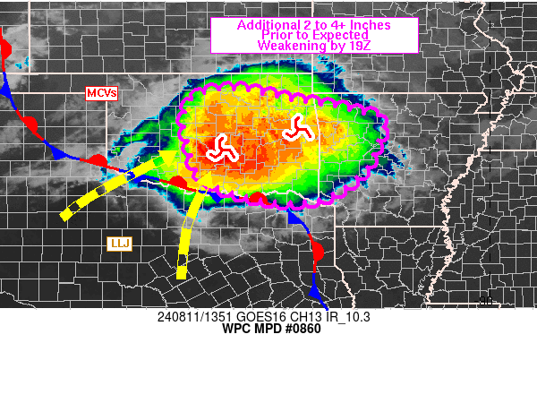
Mesoscale Precipitation Discussion 0860
NWS Weather Prediction Center College Park MD
955 AM EDT Sun Aug 11 2024

Areas affected...eastern OK into western AR

Concerning...Heavy rainfall...Flash flooding likely

Valid 111354Z - 111850Z

SUMMARY...Areas of flash flooding are likely to continue over the
next 1-3 hours over eastern OK into western AR, but weakening of
the MCS should allow the flash flood threat to wane through 19Z.
An additional 2-4 inches, with localized additional totals near 5
inches, will be possible.

DISCUSSION...Radar and infrared satellite imagery showed an
ongoing MCS over central and eastern OK at 1330Z with a motion
toward the ESE. Cloud tops have been warming over the past hour
but remained cold with pockets below -70 C on 10.3 micron imagery.
Two embedded mesoscale circulations were located within the MCS,
one over southern Pottawatomie County and the other in western
Sequoyah County, both associated with the highest ongoing rainfall
rates. This system has had a history of generating 2 to 3+ in/hr
rainfall rates and localized storm totals over 8 inches so far,
overwhelming dry antecedent ground conditions. SPC mesoanalysis
data from 12Z showed MUCAPE over the eastern half of OK in the 500
to 1500 J/kg range, with instability decreasing toward the east
with no appreciable change noted over AR since 08Z.

Weakening of the 850 mb low level jet from 30-40 kt down closer to
20 kt by 19Z, along with veering flow (less overrunning component
across a stationary front along the Red River) is likely to be
tied to a gradual weakening of rainfall intensities. However,
flash flooding is likely to continue with training and rainfall
rates of 1-2 in/hr, locally near 3 in/hr, focused in the vicinity
of the two mesoscale circulations which are tracking toward the
ESE around a 700-500 mb ridge centered just south of Dallas-Fort
Worth, TX. Additional rainfall totals of 2-4 inches, with
localized additional totals near 5 inches through 19Z are possible.

Otto

ATTN...WFO...FWD...LZK...OUN...SHV...TSA...

ATTN...RFC...ABRFC...LMRFC...NWC...

LAT...LON   36599663 36379546 36289497 36139407 36039358
            35949326 35799274 35069300 34509325 33729446
            33779615 34289750 34989779 35589795 36359777
Download in GIS format: Shapefile
| KML
Note: This service is not intended for secure transactions such as banking, social media, email, or purchasing. Use at your own risk. We assume no liability whatsoever for broken pages.
Alternative Proxies: