Mesoscale Precipitation Discussion 0868
NWS Weather Prediction Center College Park MD
545 AM EDT Mon Aug 12 2024

Areas affected...Northeast to East-Central OK...Southeast KS...Far
Southwest MO...Northwest AR

Concerning...Heavy rainfall...Flash flooding likely

Valid 120945Z - 121545Z

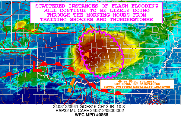
SUMMARY...Scattered instances of flash flooding will be likely
going through the morning hours from areas of training showers and
thunderstorms. This will include a threat for locally significant
urban flash flooding impacts.

DISCUSSION...The latest GOES-E IR satellite imagery shows a strong
cold-topped MCS with multiple overshooting tops impacting
northeast OK. Much of convection is generally oriented in a
northwest to southeast fashion with some areas of cell-training
occurring. The activity early this morning continues to be
organizing in response to low-amplitude shortwave energy
interacting with a strengthening southwest low-level jet of 40 to
50 kts which is overrunning a warm front to south. This is
promoting a strong corridor of moisture and instability transport
up across central to the northeast OK which is generally aligned
orthogonal to the southwest flank of the larger scale convective
mass.

MUCAPE values across central to northeast OK are currently on the
order of 1000 to 2000 J/kg and this coupled with strong isentropic
ascent and moisture convergence will favor convective sustenance
well through the morning hours with a continuation of strong
cell-training concerns given the orientation of the convection
with the deeper layer steering flow. Supporting this will be a
northwest to southeast axis of relatively strong effective bulk
shear reaching 30 to 40+ kts and this will continue to support
corridors of very well-organized and strong elevated convective
cells.

Given the combination of favorable kinematics and thermodynamics
within a very moist regime with PWs near 2 inches, the rainfall
rates at least through early this morning should be capable of
reaching 2 to 3 inches/hour with the stronger cells. Some
weakening of the low-level jet is expected by later this morning
which will then allow for the convection to begin weakening and
losing its organization.

However, given the cell-training concerns going through the
mid-morning hours, some additional rainfall amounts of 3 to 6
inches will be possible with the heaviest rains likely to be
focused over areas of northeast to east-central OK. At least
scattered instances of flash flooding are likely, and there may be
some locally significant urban flash flooding concerns. Some
convection should eventually impact areas of northwest AR later
this morning, and portions of southeast KS and far southwest MO
will also see at least some locally heavy showers and
thunderstorms, but the dominant threat area for flash flooding
will be over areas of northeast to east-central OK.

Orrison

ATTN...WFO...ICT...LZK...OUN...SGF...SHV...TSA...

ATTN...RFC...ABRFC...LMRFC...NWC...

LAT...LON   37729594 37519470 36739390 35619347 34589387
            34399513 34969592 36189650 37149658
Download in GIS format: Shapefile
| KML
Note: This service is not intended for secure transactions such as banking, social media, email, or purchasing. Use at your own risk. We assume no liability whatsoever for broken pages.
Alternative Proxies: