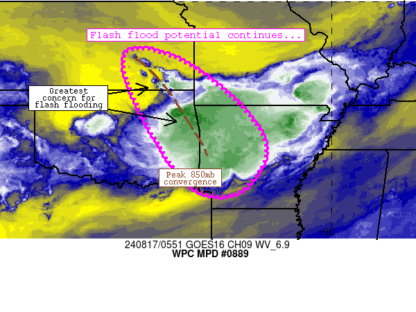
Mesoscale Precipitation Discussion 0889
NWS Weather Prediction Center College Park MD
155 AM EDT Sat Aug 17 2024

Areas affected...southeastern Kansas, northeastern Oklahoma,
western/central Arkansas

Concerning...Heavy rainfall...Flash flooding possible

Valid 170554Z - 171154Z

Summary...Flash flood potential continues as backbuilding
convection continues to increase in coverage across southeastern
Kansas and northeastern Oklahoma.  This risk should continue
through at least 12Z.

Discussion...A lead convective complex has matured while
forward-propagating southeastward across portions of western and
central Arkansas.  These storms are in a moist/unstable
environment, with 1.8+ inch PW values supporting spots of 1-1.5
inch/hr rain rates despite the brevity of heavier rainfall.  These
rates are overspreading areas of FFG thresholds in the 3 inch/hr
range, suggesting that any flash flood potential will be quite
spotty/isolated and tied to sensitive/low-lying areas.

Farther upstream, elevated convection has managed to redevelop
along an axis extending from near Chanute, KS south-southeastward
to near Talequah, OK.  These storms were focused on the nose of
20-25 knot 850mb flow while also orienting parallel to
northwesterly flow aloft.  The orientation of this convection
(along with ~2 inch PW values and near ~7C/km mid-level lapse
rates) is a bit more favorable for training and spots of 1-2
inch/hr rain rates.  Furthermore, this rainfall will occur over
wetter ground conditions from prior rainfall from the
aforementioned MCS earlier in the evening, and lower FFG
thresholds (generally in the 1-2 inch/hr range) are noted.  The
overall pattern is a bit more favorable for flash flooding through
the night especially near axes of training.

Models suggest that the 850mb convergence axis will likely persist
across southeastern Kansas through western Arkansas even as
low-level flow veers through the early morning.  Spots of 1-2
inch/hr rain rates are expected to continue through 12Z.  Isolated
3-4 inch rainfall totals are possible in this regime.

Cook

ATTN...WFO...ICT...LZK...SGF...SHV...TOP...TSA...

ATTN...RFC...ABRFC...LMRFC...MBRFC...NWC...

LAT...LON   38309689 37989506 36359297 34899223 33559323
            33919488 36619659
Download in GIS format: Shapefile
| KML
Note: This service is not intended for secure transactions such as banking, social media, email, or purchasing. Use at your own risk. We assume no liability whatsoever for broken pages.
Alternative Proxies: