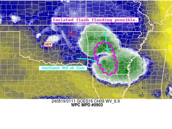
Mesoscale Precipitation Discussion 0903
NWS Weather Prediction Center College Park MD
919 PM EDT Sun Aug 18 2024

Areas affected...Western Arkansas

Concerning...Heavy rainfall...Flash flooding possible

Valid 190119Z - 190559Z

Summary...Scattered cell clusters are developing across the
Northeast and Mid-Atlantic. Rainfall rates upwards of 2"/hr and
slow eastward translation of these storms will drive a risk of
isolated-scattered flash flooding.

Discussion...Regional radar across the Northeast Mid-Atlantic
shows expanding thunderstorm clusters along and ahead of a slow
moving cold front. These cells are exhibiting periods of training
and repeating with slow forward propagation, which led to
scattered flash flood warnings across the region.

Objective analysis estimates in the warm sector highlight a
buoyant, uncapped airmass characterized by 1500 J/kg and 1.7-2.0"
PWATs to foster rainfall rates upwards of 1.5-2"/hr. As
highlighted in MPD 901, the orientation of the mean flow parallel
to the synoptic forcing (DCVA) suggests cell clusters will be slow
to forward propagate, with northeasterly Corfidi vectors on the
order of 10-15 kts noted across the region.

While cell coverage will remain more scattered compared to further
north, the slow net cell motions will support a threat of 1-3" of
rainfall per the HREF and isolated-scattered flash flooding
through the next several hours. Areas which saw locally heavy
rainfall earlier, and urban zones will be most susceptible to
flash flooding impacts with this activity.

Asherman

ATTN...WFO...LZK...SHV...

ATTN...RFC...ABRFC...LMRFC...NWC...

LAT...LON   35429353 35299270 33419225 33179293 34149359
            34889378
Download in GIS format: Shapefile
| KML
Note: This service is not intended for secure transactions such as banking, social media, email, or purchasing. Use at your own risk. We assume no liability whatsoever for broken pages.
Alternative Proxies: