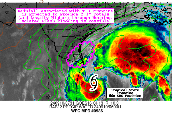
Mesoscale Precipitation Discussion 0986...Corrected
NWS Weather Prediction Center College Park MD
339 AM EDT Tue Sep 10 2024

Corrected for Storm Name

Areas affected...South TX

Concerning...Heavy rainfall...Flash flooding possible

Valid 100730Z - 101330Z

Summary...Rainfall associated with Tropical Storm Francine is
expected to produce 2-3" totals (and locally higher) through
morning. Isolated instances of flash flooding are possible.

Discussion...Showers and rainbands on the northwest periphery of
Tropical Storm Francine will increasingly impact portions of far
South TX through early morning, as the cyclone slowly moves NNW
(at ~5 mph) over the far west-central Gulf (offshore the Mexican
state of Tamaulipas). While heavy rainfall has remained mostly
offshore thus far, KBRO NEXRAD has provided good sampling for MRMS
estimates, which indicate that hourly totals have peaked between
1-2 inches. These better rates have tended to be rather fleeting,
as hourly totals of 1" or less have been much more common (and
particularly so once showers/bands move onshore). The mesoscale
environment is currently characterized by relatively low CAPE
(tight gradient of 500-1000 J/kg of ML CAPE), deep tropical
tropospheric moisture (with precipitable water values of 2.2-2.8
inches, which are near max/record levels, per BRO sounding
climatology), and a maxima of both surface moisture convergence
and deep layer moisture flux convergence near the southern tip of
TX.

A persistence forecast (with respect to shower intensity and
behavior) seems rather appropriate, given the short term
observational trends, but the slow NNW motion of Francine should
allow for increased shower activity into far southern TX. While
00z HREF 40-km neighborhood probabilities for 3" and 5" exceedance
are surprisingly high (40-50% and 25-35%, respectively), these
seem highly influenced by the 00z HRRR/FV3 and time-lagged ARW
(which are about the only members even depicting 3"+ amounts). The
subsequent HRRR runs (01z thru 03z) came in similarly hot
(localized 3-6 inches), but then subsequently cooled (localized
2-3 inches) with the most recent runs (04z thru 06z). These latest
HRRR runs are in good agreement with the 00z HREF blended mean
(average of the mean and PMM), and this closely matches the
experimental 00z REFS blended mean depiction as well. While 2-3"
totals over 6-hr should be fairly well tolerated by local soils
(per the Flash Flood Guidance generally ranging from 2.5-3.0
inches), localized 3"+ totals could result in isolated instances
of flash flooding (with portions of Brownsville likely most
vulnerable, particularly having had 2-3" over the past 24-hrs).

Churchill

ATTN...WFO...BRO...CRP...

ATTN...RFC...WGRFC...NWC...

LAT...LON   27399730 27279637 25999692 25709782 26139841
Download in GIS format: Shapefile
| KML
Note: This service is not intended for secure transactions such as banking, social media, email, or purchasing. Use at your own risk. We assume no liability whatsoever for broken pages.
Alternative Proxies: