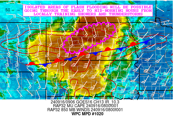
Mesoscale Precipitation Discussion 1020
NWS Weather Prediction Center College Park MD
510 AM EDT Mon Sep 16 2024

Areas affected...Central ND

Concerning...Heavy rainfall...Flash flooding possible

Valid 160910Z - 161510Z

SUMMARY...Locally training showers and thunderstorms going through
early to mid-morning may result in some isolated areas of flash
flooding.

DISCUSSION...GOES-E IR satellite imagery shows an axis of very
cold topped convection impacting portions of central ND as strong
thunderstorms developing within a well-defined warm air advection
pattern lift gradually off to the northeast. The convection is
aligned in close proximity to a frontal zone and a rather strong
instability gradient with MUCAPE values of as much as 2000 J/kg
noted across areas of central and southern ND.

MRMS data has been showing some rainfall rates with the activity
reach as high as 1.5 to 2.5 inches/hour and this is being aided by
rather strong moisture transport associated with the nose of a 30+
kt southerly low-level jet.

Going through the early to mid-morning hours, there may be some
additional concentration and alignment of convection that will
promote some cell-training in close proximity to the front.
Additionally, there is some weak vort energy/MCV activity arriving
from weakening convection over western SD, and this energy may
interact with the front and the low-level jet to further promote
convective sustenance across areas of central ND this morning.

Additional rainfall totals of 2 to 4 inches will be possible with
isolated heavier amounts of 5 inches where any cell-training
occurs this morning. The antecedent conditions across the region
are quite dry, so any flash flooding concerns should be isolated
in nature and mainly focused within the more urbanized locations.

Orrison

ATTN...WFO...BIS...FGF...

ATTN...RFC...MBRFC...NCRFC...NWC...

LAT...LON   48859932 48609848 48069883 47389991 46650180
            47010252 47770206 48490084
Download in GIS format: Shapefile
| KML
Note: This service is not intended for secure transactions such as banking, social media, email, or purchasing. Use at your own risk. We assume no liability whatsoever for broken pages.
Alternative Proxies: