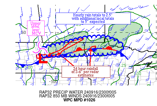
Mesoscale Precipitation Discussion 1026
NWS Weather Prediction Center College Park MD
829 PM EDT Mon Sep 16 2024

Areas affected...portions of northeast ND & northwest MN

Concerning...Heavy rainfall...Flash flooding possible

Valid 170027Z - 170627Z

Summary...Isolated to widely scattered instances of flash flooding
are expected to continue overnight.  Hourly rain totals to 2.5"
and additional local amounts to 5" are expected.

Discussion...The three recent areas of convection across northern
ND into northwest MN are beginning to bridge together as new
convection forms at the present time.  The western end moving east
of Minot is associated with an upper level low/MCV moving
northeast across ND.  Farther east in northeast ND and northwest
MN, additional thunderstorms are forming within a warm air
advection pattern ahead of a related surface wave and near its
warm front, which appears to be in the process of becoming
stationary or perhaps nudging southward due to convective outflow.
 Precipitable water values are around 1.5" per GPS data.
Effective bulk shear in the region is 25-35 kts, which is helping
to organize the thunderstorms.  MU CAPE is 1500-3000 J/kg.  CIN is
rebuilding across the region, which should keep most convection
elevated.

The upper low/MCV and its convective cluster marks the western
fringe of the heavy rain threat and is forward propagating to the
east.  Mesoscale guidance still isn't agreeable on which side of
the US/Canadian border -- if not right along it -- the rainfall
maximum is expected over the next six hours, but radar
reflectivity trends continue to support heavy rain on the U.S.
side, or the southern side of the mesoscale guidance spread.
Eastward propagation should continue.  The Canadian Regional Model
made a substantial southward shift in its 18z run, supporting the
more southward placement.  Given what's happened so far, hourly
rain totals to 2.5" and additional local amounts to 5" are
expected.  This would be most problematic in areas that received
heavy rainfall over the past 24 hours.  Due to the isolated to
widely scattered nature of the flash flooding/very heavy rainfall
thus far and uncertainty in the model guidance, continue to use
possible wording over likely.

Roth

ATTN...WFO...BIS...DLH...FGF...

ATTN...RFC...MBRFC...NCRFC...NWC...

LAT...LON   49509618 49459488 48669337 48089390 47919566
            47899642 47869755 47760140 48160139 48370122
            48729983 49129838 49389725
Download in GIS format: Shapefile
| KML
Note: This service is not intended for secure transactions such as banking, social media, email, or purchasing. Use at your own risk. We assume no liability whatsoever for broken pages.
Alternative Proxies: