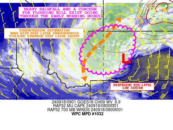
Mesoscale Precipitation Discussion 1032
NWS Weather Prediction Center College Park MD
505 AM EDT Wed Sep 18 2024

Areas affected...Central MT

Concerning...Heavy rainfall...Flash flooding possible

Valid 180905Z - 181505Z

SUMMARY...Heavy rainfall is expected to become more concentrated
going through dawn and the early morning hours across portions of
central MT. Generally this setup will favor an areal flood threat,
but around any burn scar locations, there will be a more enhanced
runoff concern with potential for localized flash flooding.

DISCUSSION...A deepening upper-level trough and associated area of
low pressure lifting up across the northern High Plains will be
driving a rather impressive heavy rainfall event beginning early
this morning across central MT. Facilitating this will be the
evolution of a well-defined TROWAL working in tandem with an
increasingly focused area of deep layer frontogenesis along with a
strong mid-level deformation zone. This should yield enhanced
forcing to help concentrate the heavy rainfall threat in time
which will also include an increase in rainfall rates.

Gradually the heavy rainfall axis should tend to become oriented
in a general south-southwest to north-northeast fashion around the
northwest flank of the deepening 500/700 mb mid-level low center
and where frontogenetical forcing will be the strongest. However,
there is already a fair amount of instability attempting to wrap
westward around the north side of the deepening low, and there
will likely be a corridor of elevated convective elements that
will help drive locally heavier rainfall rates early this morning.

The 00Z HREF guidance and recent runs of the HRRR suggest as much
as 2 to 4+ inches of rain may fall through the early morning hours
(15Z/9AM MDT), with some occasional rainfall rates that may reach
upwards of 0.75" to 1"/hour with some of the stronger convective
elements that materialize.

These rains are expected to gradually drive an areal flood threat,
which may also include a threat for localized flash flooding
around any burn scars that receive some of these heavier rainfall
rates.

Orrison

ATTN...WFO...BYZ...GGW...TFX...

ATTN...RFC...MBRFC...NWC...

LAT...LON   49270843 48780760 47520767 46370826 45740926
            45751071 46221151 47041177 47821154 48601088
            49220976
Download in GIS format: Shapefile
| KML
Note: This service is not intended for secure transactions such as banking, social media, email, or purchasing. Use at your own risk. We assume no liability whatsoever for broken pages.
Alternative Proxies: