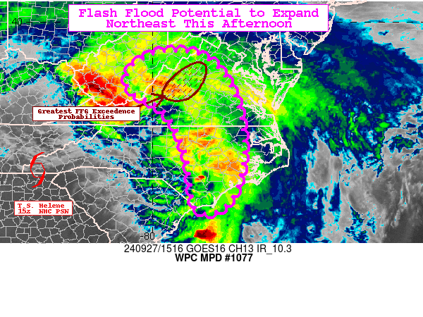
Mesoscale Precipitation Discussion 1077
NWS Weather Prediction Center College Park MD
1125 AM EDT Fri Sep 27 2024

Areas affected...Eastern NC into central VA and parts of central
WV

Concerning...Heavy rainfall...Flash flooding likely

Valid 271524Z - 272124Z

SUMMARY...Heavy showers expanding northward with the main plume of
tropical moisture associated with Tropical Storm Helene will shift
into the central Appalachians this afternoon and could contain
rainfall rates of 1-2", likely producing areas of flash flooding.
Line of showers and thunderstorms progressing east-northeast
across central/eastern NC extending into central VA this afternoon
may briefly train and create flash flooding concerns.

DISCUSSION...The center of Tropical Storm Helene is crossing the
southern Appalachians late this morning as broad, strong
southeasterly flow continues to pump a moist tropical airmass into
the Mid-Atlantic. The core of the 850mb jet (50-60+ kts) is
lifting northward along with the warm conveyor of moisture
stretching all the way back to the Gulf of Mexico. Favorable
upslope flow into the central Appalachians and central/northern VA
section of the Blue Ridge will support hourly rainfall rates of
1-2", which will likely overwhelm widespread hourly FFGs less than
1" in the sensitive terrain of VA. MUCAPE values around 500 J/kg
just east of the Blue Ridge will also increase chances for locally
intense rainfall where embedded storms wrap northwestward around
the main circulation. HREF neighborhood probabilities for
exceeding 3-hourly FFG are high (>80%) along the Blue Ridge of
central/northern VA.

Rainfall rates per MRMS in the N-S oriented line of storms across
central NC are in the 1-3" range. Although mostly moving
progressively northeastward, parallel upper flow supports the
potential for brief training, which could lead to areas of flash
flooding. The environment also contains PWs of 2-2.5" and MLCAPE
of 1000-2000 J/kg advected northward from the coastal Carolinas.
Storms should be able to maintain themselves and could turn
supercellular as effective bulk shear remains elevated and above
50 kts for much of the Carolinas. Rainfall amounts of 1-3" are
possible per the latest CAMs. 06z HREF neighborhood probabilities
for at least 3" in 3-hours (also near the regions FFG) are around
20-40%.

Snell

ATTN...WFO...AKQ...ILM...LWX...MHX...PBZ...RAH...RLX...RNK...

ATTN...RFC...MARFC...OHRFC...SERFC...NWC...

LAT...LON   38987981 38947853 38277766 37087713 35327700
            33987753 33797853 35727890 37057961 37738073
            38448075
Download in GIS format: Shapefile
| KML
Note: This service is not intended for secure transactions such as banking, social media, email, or purchasing. Use at your own risk. We assume no liability whatsoever for broken pages.
Alternative Proxies: