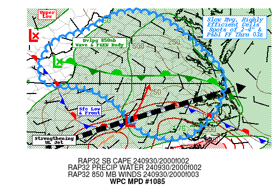
Mesoscale Precipitation Discussion 1085
NWS Weather Prediction Center College Park MD
542 PM EDT Mon Sep 30 2024

Areas affected...Southern VA...Northern NC...Far Southeast WV...

Concerning...Heavy rainfall...Flash flooding possible

Valid 302140Z - 010330Z

SUMMARY...Slow moving, shallow but efficient tropical showers
capable of localized 2-4" totals by early overnight.  Flash
flooding possible, though more likely in terrain where FFG is
critically low.

DISCUSSION...GOES-WV and AMVs show strengthening upper-level jet
streaking across the Carolinas to offshore along/ahead of positive
tilt trough starting to kick out of the central Appalachians.  At
the surface, a stubborn stationary front extends from the Outer
Banks acros central NC before angling north across the central
Appalachians toward the core of the upper-low that is over
southern WV.  Short-wave energy from mid-level trough and cyclonic
shear from the jet is providing modest DPVA across S VA and
spurring a surface wave near JNX which is expected to lift
northward into SE VA later tonight.  It is also supporting 850-700
low developing across SW VA with a sharp 850mb FGEN  with both
speed and directional convergence maximized from LYH to RIC,
sliding east toward AKQ.  Alignment with the surface wave will
steepen the isentropes for increasing vertical development even as
instability wanes after sunset.  Proximity to the warm sector
across SE VA/NE NC will support stronger, broader updrafts with
deeper overall moisture up to 2" of TPW which may allow for deeper
and more efficient warm cloud layer to support rates in excess of
2.5"/hr.  However, deeper steering may limit duration, especially
further south and east from the surface low and 850mb boundary.
As such, there are modest Hi-Res CAM signals of totals over 3-4"
with 18z HREF probability of 50-70% of 3" by 03z across E NC but
this area is a bit less saturated and has higher FFG, so flash
flooding may still be possible and scattered to widely scattered.

Further west, the potential remains the greatest given the
hydrological conditions are compromised.  FFG values of less than
1" exist through the terrain and eastern slopes of the Blue Ridge,
so even lighter/shallower showers will be at risk of inducing
localized flash flooding conditions.    Steering flow along and
east of the upper-low will be very weak and with northerly low
level winds across NoVA; could sharpen and eastward propagation.
Instability remains the limiting factor and is already reducing
from 750 J/kg to 500 J/kg.  Still directional confluence of moist
low level flow in proximity to orography should still allow for
mass convergence in the lowest levels supporting efficient widely
scattered cells capable of 1"/hr rates particularly across SE
WV/SW VA and perhaps across central VA. While not as high, there
are still modest 30-40% probability of localized 3" totals, this
would likely induce flash flooding, but the scale/size of updrafts
and areal coverage may be too focused to have higher confidence
overall.

Gallina

ATTN...WFO...AKQ...LWX...MHX...RAH...RNK...

ATTN...RFC...MARFC...OHRFC...SERFC...NWC...

LAT...LON   38537888 38467790 37647673 36717597 35687628
            35047715 35217820 36087908 36467991 36668110
            37638085 38077978
Download in GIS format: Shapefile
| KML
Note: This service is not intended for secure transactions such as banking, social media, email, or purchasing. Use at your own risk. We assume no liability whatsoever for broken pages.
Alternative Proxies: