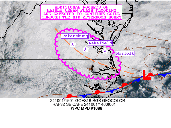
Mesoscale Precipitation Discussion 1088
NWS Weather Prediction Center College Park MD
1109 AM EDT Tue Oct 01 2024

Areas affected...Southeast VA...Far Northeast NC

Concerning...Heavy rainfall...Flash flooding likely

Valid 011508Z - 012108Z

SUMMARY...Very efficient shower activity with heavy rainfall rates
will continue through at least mid-afternoon. Additional areas of
mainly urban flash flooding are expected from Petersburg through
Wakefield and potentially the broader Norfolk/Hampton Roads region.

DISCUSSION...The latest surface observations show an inverted
surface trough across southeast VA which is extending northwest
from an area of low pressure offshore of the southern Mid-Atlantic
coast. This is fostering an axis of relatively strong moisture
convergence from near the Petersburg area on down through
Wakefield and into the Norfolk/Hampton Roads vicinity. Some modest
instability is noted across coastal areas of southeast VA and also
into northeast NC where SBCAPE values are as high as 500 J/kg.

A combination of the moisture convergence and modest instability
along with some subtle mid-level forcing/troughing still crossing
the Mid-Atlantic states has been resulting in areas of
slow-moving, but very efficient shower activity. In fact, cloud
top temperatures associated with the shower activity are quite
warm, and with a very moist environment characterized by 1.75 inch
PWs, there have been some high rainfall rates that have
occasionally been reaching 1.5 inches/hour. Areas near Wakefield
in particular have seen some of the heaviest rainfall over the
last couple of hours.

As the low-level surface trough cyclonically pivots down to the
southeast with time as the offshore surface low begins to pull
away, there should tend to be a gradual southeastward shift of the
shower activity going through the mid-afternoon hours. This may
allow for some of the heavier shower activity to get into the
Norfolk/Hampton Roads area, but also adjacent areas of far
northeast NC.

The latest 12Z HREF guidance suggests some localized pockets of
additional rainfall reaching 2 to 4 inches. Rainfall rates are
expected to remain as high as 1 to 1.5 inches/hour with the more
focused and heavier shower activity.

At least in the near-term, given the ongoing pockets of urban
flash flooding around Petersburg and Wakefield, and with the
additional rainfall threat, it generally appears likely that
additional areas of flash flooding can be expected through
mid-afternoon before conditions then begin to improve.

Orrison

ATTN...WFO...AKQ...MHX...RAH...

ATTN...RFC...MARFC...SERFC...NWC...

LAT...LON   37747764 37557691 36957600 36367565 35907585
            35917690 36627798 37487812
Download in GIS format: Shapefile
| KML
Note: This service is not intended for secure transactions such as banking, social media, email, or purchasing. Use at your own risk. We assume no liability whatsoever for broken pages.
Alternative Proxies: