Mesoscale Precipitation Discussion 1120
NWS Weather Prediction Center College Park MD
111 AM EST Mon Nov 04 2024

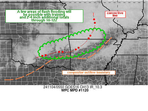
Areas affected...eastern OK, northwestern AR, southern MO

Concerning...Heavy rainfall...Flash flooding possible

Valid 040610Z - 041030Z

Summary...Periods of training convection may result in a few areas
of flash flooding from eastern OK into northwestern AR and
southern MO through 11Z. 2 to 4 inches of rain is expected where
training sets up.

Discussion...A composite outflow boundary was analyzed at 06Z from
the eastern MO/AR border into central AR, eastern OK and then
southwestward across the Red River between Denison and Wichita
Falls, TX. Elevated thunderstorms were occurring to the north of
the outflow with an eastward advancing contiguous convective line
from central MO into northwestern AR. Convective line progression
was stalled or retrograding slightly to the north over
northwestern AR and a fragmented/broken axis of thunderstorms
extended westward from northwest AR into central OK with
individual cell motions off toward the NNE but better organization
was lacking over OK. Southerly low level winds were overrunning
the boundary supporting the continued regeneration of
thunderstorms, acting on 1000-2000 J/kg MLCAPE along and south of
the outflow boundary in eastern OK. While the better 850 mb flow
was located ahead of the advancing convective line in MO/AR, 30 to
50 kt of S to SSW 850 winds were reported via VAD wind data to the
south of the outflow from eastern OK into northern TX.

The eastward advancing convective line in MO/northern AR is
expected to continue pushing off toward the east but back to the
west in OK, the outflow boundary is expected to continue a modest
retreat northward within deep-layered S to SW flow ahead of a
longwave trough over the Four Corners region. Isentropic ascent
across the composite outflow boundary will likely maintain some
degree of convective regeneration over central to eastern OK into
far western AR through 11Z. While not forecast to be widespread,
instances of training will occur where convective orientation
aligns with the deeper layer SSW steering flow. Training will
support rainfall rates of 1-2 in/hr, some of which will overlap
with saturated top layer soils given recent heavy rainfall over
the past 24-36 hours.

Areas of training are expected to be transient and scattered
across the region overnight. Recent hires guidance does not have a
good handle on the progression and timing of convection compared
to recent radar trends, so their forecast coverage of 3 to 6
inches through 12Z may be overdone. Nonetheless, 2-4 inches in a
few locations is still expected which may lead to a few areas of
flash flooding.

Otto

ATTN...WFO...LZK...OUN...SGF...TSA...

ATTN...RFC...ABRFC...LMRFC...MBRFC...NWC...

LAT...LON   37399216 37059129 36369142 35739212 35039398
            34879485 34829630 34919710 35249739 35859701
            36109634 36449520 36969385
Download in GIS format: Shapefile
| KML
Note: This service is not intended for secure transactions such as banking, social media, email, or purchasing. Use at your own risk. We assume no liability whatsoever for broken pages.
Alternative Proxies: