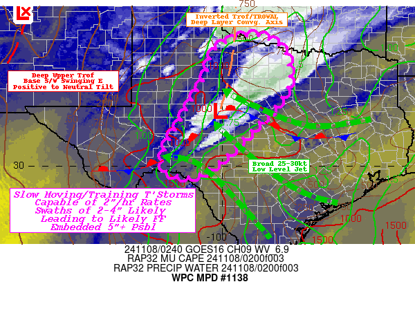
Mesoscale Precipitation Discussion 1138
NWS Weather Prediction Center College Park MD
954 PM EST Thu Nov 07 2024

Areas affected...Lower Pecos/Concho Valleys into Northwest Texas
Big Country...

Concerning...Heavy rainfall...Flash flooding likely

Valid 080300Z - 080830Z

SUMMARY...Slow moving/training thunderstorms with 1.75-2"/hr rates
pose line of 2-4" totals with possible embedded 5+"  resulting in
likely incidents of flash flooding through the overnight period.

DISCUSSION...GOES-E WV suite continues to show anomalously deep
closed low over northern NM with broad southwesterly flow aloft
crossing the Southern High Plains.  While the upper-low is filling
slowly, there are two main vorticity centers with the northern
swinging around the NE side of the circulation int SE CO, while
the base energy is starting to advance out of AZ.  This continues
to support a very strong and diffluent jet across much of western
Texas providing a broad area of vertical ascent.  Near the
surface, the low level jet has been responding throughout the
evening with solid 30 kt south-easterly flow. Initial surge of
enhanced moisture has already intersected the deeper NNE to SSW
convergence axis from NW TX toward the Lower Pecos River Valley
and has brought total PWat values into the 1.5" range in proximity
to the western edge of the instability gradient and has supported
expanding clusters of thunderstorms with a few rotating updrafts
within a cluster or two across E OK into the northern Concho
Valley, with a few more individual cells further south.  CIRA LPW,
notes that a secondary surge especially in the surface to 850mb
layer is starting to reach the Lower Pecos and into Concho Valley
with .6 to .75" values at the nose of the 30kts, this will
continue through the early overnight period and eventually expand
along the length of the convergence axis (area of concern).  This
will increase convective coverage as well as moisture flux into
the cells.  Modest instability (1000+ J/kg) will be aided by the
divergence aloft to maintain stronger updrafts and result in
expanding downdrafts capable of 1.5-2"/hr.

Greater concern is going to be residency of this
ascent/convergence axis to allow for additional development
(particularly upstream in SW TX where a weak 850mb low will be
forming and lifting northward through the evening with the
approaching height-falls/dPVA.   As the base shortwave swings
east, overall orientation of the flow will back more southerly and
allow for deeper steering flow to align more with the generally
stationary convergence axis.   Cells further south near the
surface low (between) SJT/BRD and frontal zone, cells may have
increased depth of moisture flux...before becoming more elevated
across Nw Texas.  As such, training may result in a band of
excessive rainfall totals of 3-4" with embedded spots over 5" not
out of the realm of possibility.  While areas of the Concho/Pecos
Valley have higher FFG values, there remains solid likelihood of
exceeding resulting in flash flooding conditions tonight.  Lower
FFG values from Nolan/Callahan and points north increase the
potential for exceedance (<2"/hr & 2-2.5" in 3hrs).  As such,
flash flooding is considered likely and with above normal
confidence given the overlapped weather elements and fairly solid
agreement in the Hi-Res CAM suite.

Gallina

ATTN...WFO...EWX...FWD...LUB...MAF...OUN...SJT...

ATTN...RFC...ABRFC...WGRFC...NWC...

LAT...LON   34389920 34239832 33599779 32579782 31509872
            30699954 30140012 29650110 29940199 30700183
            31550137 32950059 33940019
Download in GIS format: Shapefile
| KML
Note: This service is not intended for secure transactions such as banking, social media, email, or purchasing. Use at your own risk. We assume no liability whatsoever for broken pages.
Alternative Proxies: