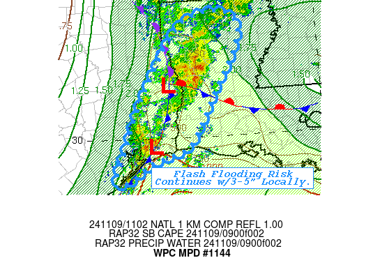
Mesoscale Precipitation Discussion 1144
NWS Weather Prediction Center College Park MD
605 AM EST Sat Nov 09 2024

Areas affected...Southeast TX...Western LA...

Concerning...Heavy rainfall...Flash flooding possible

Valid 091100Z - 091600Z

SUMMARY...Slow moving, highly efficient cells along the front will
continue to produce pockets of heavy rainfall and totals capable
of inducing localized flash flooding.  Scattered totals over 3-5"
remain possible.

DISCUSSION...Deep layer convergence through the warm sector over
the northern Gulf and southern LA continues to drive convective
development along the slowing/approaching cold fronta across SE
TX.  Strong upper-level divergence at the inflection of the
cyclonically curved jet with maximized diffluence aloft as further
enhanced/expanded convective development and isentropic ascent
along and east of the triple point northeast of JAS, TX.  CIRA LPW
shows enanced surface to 700mb moisture through the warm sector
though stronger 700-500 moisture along the northern coreo of
Rafael remains distant enough for stronger WAA ascent later today.
 So with some weak steepening of lapse rates, modest instability
remains in proximity of the Sabine River Valley to the triple
point and should help to maintain updraft strength and focus
moisture flux convergence to support 2-2.5"/hr rates.  Duration of
heavy rainfall may be more limited further north towad the
entrance of the jet/divergence maxima as it slides away with the
speed max with time.  Spots of 2-4" across west-central to
north-central LA may result in possible flash flooding over the
next few hours.

Furhter south, the east-southeast surface to 850mb flow
decelerates into a col/weak surface wave near BPT.  As such,
similar deep layer moisture convergence and slightly enahnced
surface based CAPE of ~1500 J/kg (due to proximity to the warmer
Gulf) is providings stronger updraft strength.  Due to proximity
of slower low to midlevel flow, cells have been a bit more
stationary/slow moving with time and some suggestion of upstream
redevelopment toward the south may allow for some repeating;
duration may continue to result in very localized but intense
rainfall up to 2.5"/hr and localized totals of 3-5" over the next
few hours.  Given higher natural FFG values (only locally reduced
due to 5-8" totals over Hardin, E Liberty and NW Jefferson
counties), flash flooding from similar cells may continue risk for
flash flooding.

Gallina

ATTN...WFO...HGX...LCH...SHV...

ATTN...RFC...LMRFC...WGRFC...NWC...

LAT...LON   32749283 32599214 32029213 31029271 29919333
            29709366 29439446 29149487 28989532 29809504
            30979455 32399364
Download in GIS format: Shapefile
| KML
Note: This service is not intended for secure transactions such as banking, social media, email, or purchasing. Use at your own risk. We assume no liability whatsoever for broken pages.
Alternative Proxies: