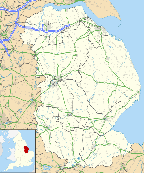
Size of this PNG preview of this SVG file: 499 × 600 pixels. Other resolutions: 200 × 240 pixels | 399 × 480 pixels | 639 × 768 pixels | 852 × 1,024 pixels | 1,704 × 2,048 pixels | 1,086 × 1,305 pixels.
Original file (SVG file, nominally 1,086 × 1,305 pixels, file size: 2.71 MB)
File history
Click on a date/time to view the file as it appeared at that time.
| Date/Time | Thumbnail | Dimensions | User | Comment | |
|---|---|---|---|---|---|
| current | 19:01, 26 September 2010 |  | 1,086 × 1,305 (2.71 MB) | Nilfanion | {{Information |Description=Map of Lincolnshire, UK with the following information shown: *Administrative borders *Coastline, lakes and rivers *Roads and railways *Urban areas Equirectangular map projection on WGS 84 datum, with N/S str |
File usage
More than 100 pages use this file. The following list shows the first 100 pages that use this file only. A full list is available.
- Alford, Lincolnshire
- Alkborough
- Ancaster, Lincolnshire
- Appleby, Lincolnshire
- Bardney
- Barton-upon-Humber
- Belmont transmitting station
- Belton, South Kesteven
- Blackfriars Theatre and Arts Centre
- Bolingbroke, Lincolnshire
- Boothby Graffoe
- Boston, Lincolnshire
- Boston Guildhall
- Bourne, Lincolnshire
- Bracebridge Heath
- Brampton, Lincolnshire
- Branston, Lincolnshire
- Brigg
- Broughton, Lincolnshire
- Burton, Lincolnshire
- Burwell, Lincolnshire
- Butterwick, Lincolnshire
- Byard's Leap
- Caistor
- Cleethorpes
- Coleby, North Kesteven
- Coningsby
- Cranwell
- Crowland
- Crowle, Lincolnshire
- Deeping St James
- Denton, Lincolnshire
- Digby, Lincolnshire
- Donna Nook
- Dorrington, Lincolnshire
- East Kirkby
- Epworth, Lincolnshire
- Flixborough
- Gainsborough, Lincolnshire
- Gainsborough Old Hall
- Gedney, Lincolnshire
- Gibraltar Point, Lincolnshire
- Grantham
- Grimsby
- Haddington, Lincolnshire
- Harlaxton Manor
- Harmston
- Haverholme Priory
- Holbeach
- Holbeach Air Weapons Range
- Horncastle
- Immingham
- Lincoln Castle
- Louth, Lincolnshire
- Mablethorpe
- Market Deeping
- Market Rasen
- Mavis Enderby
- Metheringham
- Minting
- Nettleham
- New York, Lincolnshire
- Nocton
- North Ings Farm Museum
- North Thoresby
- Norton Disney
- Nunsthorpe
- RAF Barkston Heath
- RAF Coningsby
- RAF Cranwell
- RAF Digby
- RAF Scampton
- RAF Waddington
- Read's Island
- Salmonby
- Saltfleet
- Saltfleetby
- Sausthorpe
- Scartho
- Scopwick
- Scunthorpe
- Sempringham
- Skegness
- Sleaford
- South Ormsby
- Spalding, Lincolnshire
- Spilsby
- Stainton by Langworth
- Stamford, Lincolnshire
- Sutton Bridge
- Swallow, Lincolnshire
- Tathwell
- Tattershall
- Temple Bruer Preceptory
- Tupholme
- Twenty, Lincolnshire
- Waddington, Lincolnshire
- Whitton, Lincolnshire
- Winterton, Lincolnshire
- Woolsthorpe-by-Colsterworth
View more links to this file.
Global file usage
The following other wikis use this file:
- Usage on ar.wikipedia.org
- Usage on azb.wikipedia.org
- Usage on bg.wikipedia.org
- Usage on ceb.wikipedia.org
- Usage on de.wikipedia.org
- Usage on el.wikipedia.org
- Usage on es.wikipedia.org
- Lincoln (Reino Unido)
- Castillo de Bolingbroke
- Catedral de Lincoln
- Plantilla:Mapa de localización de Lincolnshire
- Scunthorpe
- Long Sutton (Lincolnshire)
- Grimsby
- Allington
- Eagle (Lincolnshire)
- Digby
- Donington (Lincolnshire)
- Deeping St Nicholas
- Crowland
- Ancaster
- Cranwell RAF College and Airfield
- Horncastle
- Bassingham
- Bardney
- Alford (Lincolnshire)
- Barkston
- Barrowby
- Baston (Lincolnshire)
- Bicker
- Billingborough
- Billinghay
- Binbrook
- Blyton
- Bourne (Lincolnshire)
- Bracebridge Heath
- Dunholme
- Dunston (Lincolnshire)
- Fishtoft
- Kirton (Lincolnshire)
- Huttoft
- Ingham (Lincolnshire)
- Keelby
- Langtoft
- Fiskerton
- Northgate
- Nocton
- Normanby-by-Spital
- North Hykeham
- Stickney (Lincolnshire)
- Spilsby
View more global usage of this file.