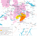
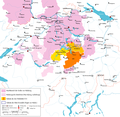
File:Historische Karte CH 1315.png
Appearance

Size of this preview: 617 × 599 pixels. Other resolutions: 247 × 240 pixels | 494 × 480 pixels | 791 × 768 pixels | 1,054 × 1,024 pixels | 2,000 × 1,943 pixels.
Original file (2,000 × 1,943 pixels, file size: 411 KB, MIME type: image/png)
File history
Click on a date/time to view the file as it appeared at that time.
| Date/Time | Thumbnail | Dimensions | User | Comment | |
|---|---|---|---|---|---|
| current | 04:42, 4 July 2010 |  | 2,000 × 1,943 (411 KB) | DcoetzeeBot | Remove watermark, add author and license data to image metadata, decrease filesize with pngcrush |
| 14:47, 5 November 2006 |  | 2,000 × 1,943 (411 KB) | Sidonius | überarbeitet: Neu eingefügt die wichtigsten Pässe, Beschränkung auf wichtigste Orte und Klöster, dargestelltes Gebiet etwas kleiner, Korrekturen | |
| 20:11, 10 July 2006 |  | 3,000 × 1,884 (779 KB) | Sidonius | ||
| 16:15, 10 July 2006 |  | 3,000 × 1,884 (777 KB) | Sidonius | ||
| 10:21, 5 July 2006 |  | 3,000 × 1,884 (774 KB) | Sidonius | {{Information |Description=Die Eidgenossenschaft um 1315 (Schlacht bei Morgarten) |Source=own work |Date=5.7.2006 |Author=Marco Zanoli; ~~~~ |Permission=cc-by-sa/2.5/de; bitte Nachricht an Autor bei Verwendung ausserhalb von Wikipedia |other_versions= }} |
File usage
The following 4 pages use this file:
Global file usage
The following other wikis use this file:
- Usage on ca.wikipedia.org
- Usage on de.wikipedia.org
- Usage on eo.wikipedia.org
- Usage on es.wikipedia.org
- Usage on fr.wikipedia.org
- Usage on hy.wikipedia.org
- Usage on it.wikipedia.org
- Usage on nl.wikipedia.org
- Usage on rm.wikipedia.org
- Usage on ru.wikipedia.org
- Usage on uk.wikipedia.org