Planning Ocean Uses
Diving Deeper: Episode 55

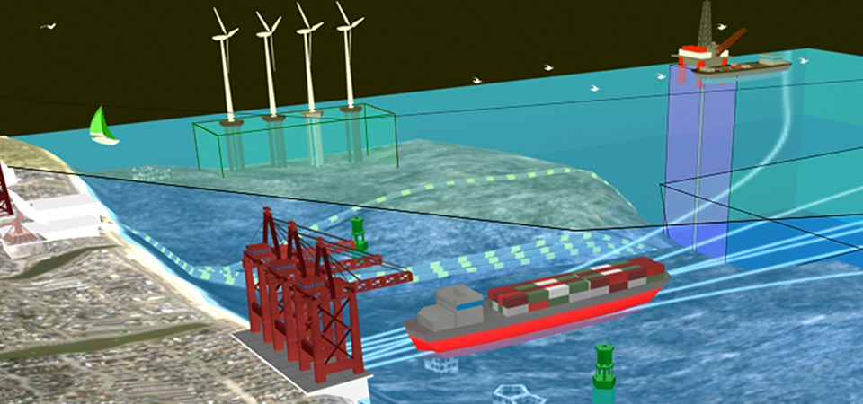
From fishing to shipping to energy, we depend on our ocean in order to do so many things every single day. With all these uses, though, there’s bound to be some overlap when it comes to human use of the ocean.
Transcript
HOST: Today on Diving Deeper, we’re going to talk ocean uses. From fishing to shipping to energy, we depend on our ocean in order to do so many things every single day. With all these uses, though, there’s bound to be some overlap when it comes to human use of the ocean.
To help us explore streamlining these various ocean uses, today we will have Cindy Fowler join us from the NOAA Coastal Services Center. Hi Cindy, welcome to our show!
CINDY FOWLER: Hi Kate. Thanks for inviting me here today.
HOST: So Cindy, to help set the stage for folks, what are some of the varying ocean uses happening every day?
CINDY FOWLER: Well, there are lots of things happening in the ocean every day that really directly impact our lives. There’s some very obvious ones like commercial uses such as shipping, fishing, and energy production all the way to the more fun things like recreation and tourism such as cruise ships, boating, and scuba diving, and according to NOAA’s data on the ocean economy, twice as many people work in ocean dependent businesses in the U.S. as in the agricultural sector, so that statistic really gives us a sense of how important ocean uses are to our economy.
HOST: Interesting stat, I didn’t know it was quite that large. As we know, the ocean is a large space…are there really competing uses at any one time or any one place?
CINDY FOWLER: Well, it does seem endless when we gaze out from the shore and the U.S. currently has the largest ocean jurisdiction in the world at over 11 million square kilometers and that’s much more than our land area, but a lot of those uses aren’t really visible from the surface or they really need a large area to support. So take something like submarine cables that are the lifeblood of the Internet and coral reefs that are the nurseries for many of our favorite seafood dishes and these uses compete for the bottom space. Or you take oil and gas infrastructure and commercial shipping for example and then for safety reasons these industries can’t generally occupy the same space. And I think the Gulf of Mexico is a really good example of an area where there’s a lot of important U.S. industries really dependent on a relatively small amount of ocean space – oil, gas, commercial fishing, tourism, and several large seaports all in that same area.
HOST: HOST: Cindy, can you give us an example of an ocean use, something that maybe provides a benefit for the marine environment?
CINDY FOWLER: Well, there’s a long list of beneficial uses and that’s really one of the best things about ocean planning is looking for those compatible ocean uses and there really are more than you would think. One of the surprises for me was the use of oil and gas infrastructure providing marine habitat. I would never have imagined that something like an offshore oil rig could be an artificial reef. That’s a really great example of one ocean use benefitting another ocean use.
HOST: And are there potential conflicts with the marine environment and ocean uses?
CINDY FOWLER: Well, unfortunately as demands on the ocean space increase so do the chance for conflicts. The oil spill in the Gulf was an example where ocean use for oil and gas impacted the ocean uses supporting seafood and tourism. And there are quite a few emerging ocean industries that have only just begun to start making use of the ocean. One of these is the wind industry which is the increasing activity and the value to the U.S. economy are a really big part of why we are so excited about working in ocean planning.
HOST: So, Cindy, what do ocean planners need to help them organize and help them streamline these many ocean uses we’ve been talking a little bit about?
CINDY FOWLER: Well, just like land use planners, ocean planners need good information and maps about their area and NOAA and the Bureau of Ocean Energy Management, also known as BOEM, joined forces many years ago at the direction of the Energy Policy Act to create an ocean information system called the marinecadastre.gov.
HOST: And Cindy what makes this ocean information system unique?
CINDY FOWLER: Well, as the name implies, just like a land cadastre that catalogs all the ownership and property rights on our land, the marinecadastre.gov is built on the top of those authoritative boundaries that designate laws and policies of the U.S. ocean area. Because we can’t really easily leave these pins and survey markers to designate jurisdictions, good data are really critical and that was an important foundational step to help us improve that jurisdictional accuracy of decision making in the ocean.
HOST: OK, so it sounds like a very valuable resource. Who are some of the key users of this data and the marinecadastre.gov?
CINDY FOWLER: We designed marinecadastre.gov for regional and state ocean planners, the federal and state regulators, and the offshore alternative energy industry like wind and wave, though we recently have been pleasantly surprised to see a lot of other users of the data and the site – the oil and gas industry in the Gulf of Mexico is using data for safety plans and safety drills and the port planning is happening in Tampa Bay with the marinecadastre.gov. So really any users who is doing a study or planning in the ocean would find something useful on marinecadastre.gov.
HOST: So Cindy, how about for some of our listeners today who may not be that immediate user of this ocean information system, what is the benefit to them that such a system exists?
CINDY FOWLER: Well Kate, one of the things that users could do is open up the marinecadastre.gov and look at the maps and see what is actually happening offshore of their state or their city or region and that may be of interest so they can get a sense of how the different industries are coming together and what the uses are.
HOST: Thank you. Cindy, what is the most common reason that planners use the marinecadastre.gov?
CINDY FOWLER: Each region has unique priorities, but primarily it’s been used to support the emerging wind energy industry from both the screening for sites or from the federal permit review side. And we really see this use growing over the next few years as that wind energy industry grows.
HOST: And can you share a success story with us from this effort, this marinecadastre.gov initiative?
CINDY FOWLER: Well, ocean planning is relatively new to the U.S. and there are many, many worldwide success stories about how it leads to better choices, but I think my favorite U.S. story is how the national marine sanctuaries were able to use this data and make a case for subtle changes to the shipping lanes and that in turn reduced the whale strikes. And so anything that supports maritime commerce and protects marine mammals, that has to be a win.
HOST: Great, thanks Cindy. And my last question for you today, is just to see if you have any closing thoughts, final words to leave our listeners with?
CINDY FOWLER: Well, these are exciting times ahead for ocean planning in the U.S., so check back often to the marinecadastre.gov for new data and products and we would love to hear your thoughts, so join us on Twitter or on our Facebook site.
HOST: Great, thanks Cindy for joining us today and talking ocean uses. To learn more, please visit www.marinecadastre.gov.
That’s all for today show – thanks for tuning in. Diving Deeper will be back in two weeks!

Connect with ocean experts in our podcast series that explores questions about the ocean environment. Get ready to Dive Deeper!
Subscribe to Feed | Subscribe in iTunes