GPS on Bench Marks
NOAA Ocean Podcast: Episode 03
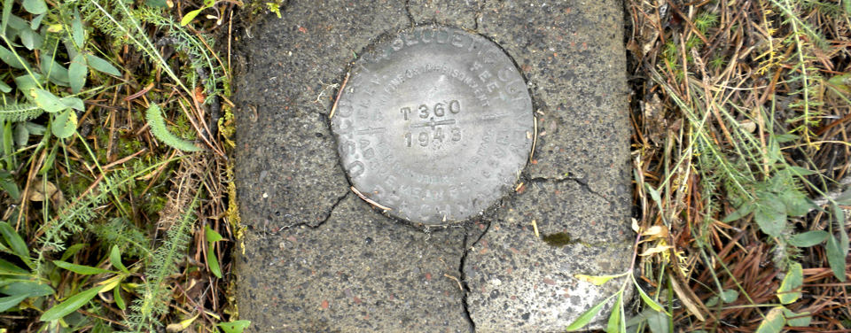
It's time for a NOAA Ocean Podcast "Science Moment," where we sample the best segments from our past full-length podcasts. In this episode, hear about an effort called GPS on Bench Marks. A bench mark is a term used to describe any permanent mark or disk that's either in the ground or attached to a large structure. This permanent mark has a known elevation or height which makes it valuable to NOAA. There are over 400,000 bench marks in the United States, and in the GPS on Bench Marks project, anyone can visit the bench mark of their choice, record field notes, take digital photos, and collect GPS observations or coordinates and then use online tools to send the information to NOAA.

There it is!
Bench marks may be hard to spot even if you have the coordinates.
Transcript
HOST: It's time for a NOAA Ocean Science Moment! I'm Megan Forbes and in today's science moment I'm taking a look back at an effort promoted by NOAA's National Geodetic Survey (or NGS) called GPS on Bench Marks. A bench mark is a term used to describe any permanent mark or disk that's either in the ground or attached to a large structure. This permanent mark has a known elevation or height which makes it valuable to NOAA. There are over 400,000 bench marks in the United States, and in the GPS on Bench Marks project, anyone can visit the bench mark of their choice, record field notes, take digital photos, and collect GPS observations or coordinates and then use online tools to send the information to NOAA.
Listen in as NOAA Ocean's Kate Nielsen talks with Christine Gallagher, the Constituent Resource Manager with NOAA's National Geodetic Survey about how you, too, can take part in this nationwide effort.
KATE NIELSEN: Christine, can you tell us more about this GPS on Bench Marks project that your office is leading?
CHRISTINE GALLAGHER: NOAA's National Geodetic Survey is promoting an effort we're calling GPS on Bench Marks. And the idea behind this project is that we're encouraging anybody from the public to go out to their area of interest and find bench marks, collect information about the bench marks, and send that information back to NGS because the information you send us could help us improve the National Spatial Reference System. We're most interested in having you send us high quality GPS data, but there is other useful information that you could send us including digital photographs and just telling us about the condition of the bench mark that you find in the field.
KATE NIELSEN: Where are these bench marks located?
CHRISTINE GALLAGHER: There are hundreds of thousands of bench marks actually located across the country. They've been installed over the past two centuries. We installed a lot of the bench marks to help us define these reference frames that we use for mapping and surveying today. Some of them are easy to find, they're found along roadways in your community. Others might be more difficult to find and are in remote locations.
KATE NIELSEN: How does someone find one of these bench marks, if they've never seen one before in their community and they're interested in participating?
CHRISTINE GALLAGHER: I would recommend that people visit the National Geodetic Survey's website and use one of our map service tools. You can use the NGS Data Explorer to actually enter in your own zip code and find bench marks that are close to you. You can find the tools that you need by going to the GPS on Bench Marks website and we've also tried to create some training and held a webinar that you can view to learn more about how you actually use these tools.
KATE NIELSEN: Is this an ongoing effort or are you just looking for volunteers over a specific timeframe, like over the next year?
CHRISTINE GALLAGHER: This is an ongoing effort. We are looking for people to help us improve the National Spatial Reference System over time. We're particularly interested in improving the National Spatial Reference System leading up to 2022 when we're going to be making some major improvements. We welcome people to help us at any time. There's also an opportunity annually to join this effort during National Surveyors' Week. It's a time when people in communities coordinate their efforts and there's a lot of publicity and a lot of opportunities to join this effort. That happens in the third week of March every year.
KATE NIELSEN: Christine, we've talked a little bit about how collecting this data gives us information for height and elevation in certain areas. What do we use height and elevation data for?
CHRISTINE GALLAGHER: Height and elevation information is used for any construction project, you know how high your home is, and it is especially important when we're talking about the way water will flow, so for flooding, risk of flooding, floodplain mapping, which is very important to everyone who owns a home or is trying to cross streets and evacuation routes during storms. Elevation information is important to all of those applications.
HOST: We hope you've enjoyed this Science Moment! If you liked this podcast and want to hear more search for The NOAA Ocean Podcast in your catcher of choice, or visit oceanservice.noaa.gov. Until next time…thanks for listening!

From corals to coastal science, connect with ocean experts to explore questions about the ocean environment.
Browse All Episodes of the NOAA Ocean podcast