Water Level Stations and their Role in Tsunami Detection
NOAA Ocean Podcast: Episode 54
Tsunamis pose a threat to our nation’s coastal communities and can have devastating impacts to lives and property. These powerful forces of nature can be caused by events like earthquakes, landslides, and even volcanic activity like the January 2022 eruption in the Tonga Islands region. Although they can’t be stopped, detecting and monitoring these waves when they occur can help warn the public of possible danger. In this episode, we speak with Paul Fanelli, Lead Oceanographer for NOAA’s National Ocean Service, Center for Operational Oceanographic Products and Services to learn how water level stations provide critical data to help issue alerts, and about the unique wave caused by the Tonga eruption.

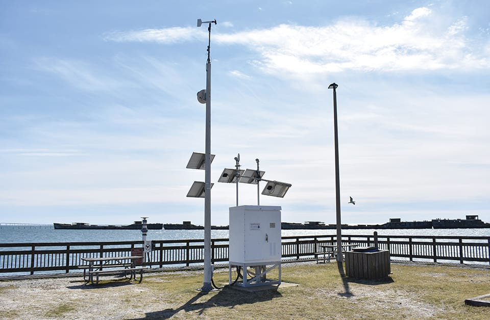
Water level stations, like this one located at Kiptopeke, VA, provide observations that help the tsunami warning centers issue accurate tsunami alerts.
Listen here:
Or listen in your favorite podcast player:
Transcript
HOST: This is the NOAA Ocean Podcast, I’m Marissa Anderson. In January 2022, an undersea volcanic eruption in the Tonga Islands region caused a powerful tsunami that threatened coastlines around the Pacific Ocean. Tsunamis can have devastating impacts to both lives and property. These waves can occur on any coast, at any time.
So how can we detect tsunamis in order to help warn the public? And can the wave that resulted from the Tonga eruption help us respond to future threats?
To find out, I spoke with Paul Fanelli, Lead Oceanographer for the Tides and Currents Office of NOAA’s National Ocean Service. Paul references it as CO-OPS in our discussion.
In his role, Paul oversees the real-time quality control of coastal water level, currents, and meteorological data collected at over 300 water level stations. This data is used to better understand day to day tides and currents, as well as coastal hazards like tsunamis.
Paul, thanks for joining us today. Can you start off by telling us how CO-OPS assists in helping to protect the public and our nation’s coastlines against tsunamis?

Paul Fanelli, Lead Oceanographer for NOAA’s National Ocean Service, Center for Operational Oceanographic Products and Services
PAUL FANELLI: CO-OPS has a vital role in helping protect the nation’s coasts against tsunamis. CO-OPS maintains a nationwide network of long-term, continuously operational real-time water level stations stretching from the Caribbean to the western Pacific. These 210 stations, which make up the National Water Level Observation Network, or NWLON, provide critical data to support recreational and commercial navigation, shoreline mapping and coastal resilience in response to changing sea levels.
HOST: How exactly do these water level stations assist with supporting tsunami response efforts?
PAUL FANELLI: CO-OPS coastal water level stations are a critical component of tsunami detection. Most stations collect and disseminate water level information in real-time every six minutes. This is sufficient for most applications like tracking the tides for navigation and even measuring storm surge from tropical storms and hurricanes. Tsunami waves can travel at 500 miles per hour or more over the open ocean. When waves reach the coast, they do slow down, but still can move onshore at speeds of 20 to 30 miles per hour. In order to record the peak tsunami wave height as precisely as possible when the wave comes ashore, CO-OPS stations are configured to transmit updated water level observations every minute and store 15-second water level measurements locally at the station, which can be retrieved remotely.

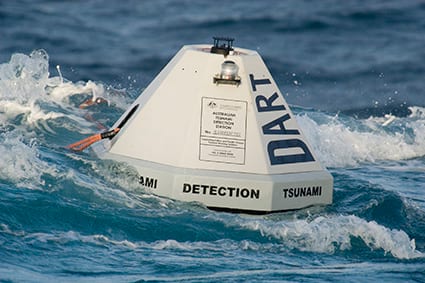
NOAA DART (Deep-ocean Assessment and Reporting of Tsunamis) buoys are located strategically throughout the ocean — often close to locations where earthquakes that generate tsunamis are likely to happen — and gather key data on sea surface levels as a tsunami travels past them. Once tsunami-generated waves reach U.S. coasts, NOAA water level stations come into play. These stations typically collect data every six minutes, sufficient for tracking tides for navigation and measuring storm surge. When tsunami wave activity is a factor, however, these stations are capable of providing water level observations at one-minute intervals to provide near-real time wave height data for coastal communities.
HOST: Wow. With tsunamis being able to move as fast as jet planes, time is of the essence when you need to warn the public. Let’s talk about the U.S. Tsunami Warning System, which is run by the NOAA Tsunami Program. What role does it play in responding to tsunami threats?
PAUL FANELLI: The U.S. Tsunami Warning System is composed of two parts. First, monitoring for tsunamis and the earthquakes that cause them and second, providing timely and accurate tsunami messages to the public to effectively warn them of potential danger. These messages are broadcast through local radio and television, wireless emergency alerts, NOAA Weather Radio and NOAA websites (like Tsunami.gov).
NOAA operates two tsunami warning centers, which are staffed 24 hours a day, seven days a week. The National Tsunami Warning Center serves the continental United States, Alaska, and Canada. The Pacific Tsunami Warning Center directly serves the Hawaiian Islands, the U.S. Pacific and Caribbean territories, and the British Virgin Islands, and is the primary international forecast center for the Pacific and Caribbean region.
HOST: How does CO-OPS support these centers?
PAUL FANELLI: CO-OPS works very closely with the tsunami warning centers to help support the tsunami warning system. The two tsunami warning centers use sea level data to verify the existence and height of a tsunami after a seismic event. The dense network of coastal water level stations maintained by CO-OPS provide the tsunami warning centers with confirmation of tsunami arrival time and height and can be used to update tsunami arrival times and potential wave heights for locations farther away.
HOST: This information helps the warning centers better communicate impacts from a tsunami and the potential danger to the public.
The January 2022 volcanic eruption in the Tonga Islands that resulted in a tsunami was a significant and unique event. Only 5% of tsunamis are caused by volcanic activity. Was the wave generated from this event different from other tsunami events?
PAUL FANELLI: While CO-OPS’ response to this event was similar to more typical tsunamis that are generated from earthquakes, the data from this event was truly unique and CO-OPS’ sensor network provided a wealth of observations that we are only beginning to analyze.
HOST: That sounds really fascinating. What would be one observation that really stood out to you?
PAUL FANELLI: One interesting feature about this event was its timing relative to the tide. When the initial tsunami waves reached Hawaii and then the west coast, many locations were close to high tide. The height of the tsunami waves on top of the tide resulted in record or near record water levels at some locations.
Observed water levels at Nawiliwili, Hawaii, were the highest since Hurricane Iniki in 1992. Water levels at Port San Luis, California, reached about three and a half feet above normal high tide, setting a new record for this location, which has data dating back to the 1940’s.
HOST: Does data generated from previous tsunamis help NOAA with predicting future tsunami events?
PAUL FANELLI: Significant tsunamis don’t occur very often so any data that NOAA can collect can be extremely useful for improving models used by the tsunami warning centers for future tsunami events. This will lead to improved, more accurate messages in order to more effectively warn the public of potential dangers.
HOST: If you’d like to dive deeper and learn more about tsunamis and NOAA’s role, check out the links in our show notes. This has been the NOAA Ocean Podcast. Thanks for listening and be sure to subscribe to us in your podcast player of choice so you never miss an episode.

From corals to coastal science, connect with ocean experts to explore questions about the ocean environment.
Social