Warning: Javascript must be enabled to use all the features on this page!
Click to hideNews Bulletins

USGS Current Water Data for the Nation


Daily Streamflow Conditions
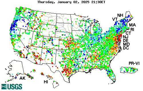

Stream gage levels in The United States, relative to 30 year average. FloridaFloridaFloridaFloridaFloridaVermontVermont New HampshireNew HampshireMassachusettsMassachusettsRhode IslandRhode IslandConnecticutConnecticutNew JerseyNew JerseyDelawareMarylandDistrict of ColumbiaMarylandMarylandMarylandWest VirginiaNew YorkSouth CarolinaIndianaWashingtonIdahoMontanaMaineOregonMinnesotaNorth DakotaMichiganWisconsinSouth DakotaWyomingCaliforniaNevadaPennsylvaniaIowaUtahNebraskaOhioIllinoisColoradoVirginiaMissouriKansasKentuckyArizonaNorth CarolinaNew MexicoTennesseeOklahomaTexasArkansasGeorgiaAlabamaMississippiLouisianaAlaskaHawaiiPuerto Rico
Explanation
[color code for] High
[color code for] > 90th percentile
[color code for] 76th - 90th percentile
[color code for] 25th - 75th percentile
[color code for] 10th - 24th percentile
[color code for] < 10th percentile
[color code for] Low
[color code for] Not ranked
The colored dots on this map depict streamflow conditions as a percentile, which is computed from the period of record for the current day of the year. Only stations with at least 30 years of record are used.
The gray circles indicate other stations that were not ranked in percentiles either because they have fewer than 30 years of record or because they report parameters other than streamflow. Some stations, for example, measure stage only.

Select a state from the map to access real-time data

Current data typically are recorded at 15- to 60-minute intervals, stored onsite, and then transmitted to USGS offices every 1 to 4 hours, depending on the data relay technique used. Recording and transmission times may be more frequent during critical events. Data from current sites are relayed to USGS offices via satellite, telephone, and/or radio telemetry and are available for viewing within minutes of arrival.

All real-time data are provisional and subject to revision.

Build Current Conditions Table Show a custom current conditions summary table for one or more stations.
Build Time Series Show custom graphs or tables for a series of recent data for one or more stations.
pFad - Phonifier reborn

Pfad - The Proxy pFad of © 2024 Garber Painting. All rights reserved.

Note: This service is not intended for secure transactions such as banking, social media, email, or purchasing. Use at your own risk. We assume no liability whatsoever for broken pages.


Alternative Proxies:

Alternative Proxy

pFad Proxy

pFad v3 Proxy

pFad v4 Proxy