Vortex-Scale Data Assimilation With HEDAS
Principal Investigator:
Project Members:
Collaborating Scientists:
- Jeff Whitaker, NOAA/ESRL/PSD
- Jeff Steward, UCLA/JIFFRESSE
- Svetla Hristova-Veleva, NASA/JPL
- Nelsie Ramos, NOAA/NHC
Funding Information:
Objectives:
- Improve high-resolution hurricane prediction by utilizing all available observations in and near the hurricane inner core
- Investigate and develop advanced data assimilation techniques for high-resolution hurricane inner-core data assimilation
- Investigate the potential impacts of existing and proposed observational platforms for hurricane inner-core data assimilation
- Develop techniques and forward operators to assimilate non-conventional observation types (such as cloudy satellite radiances) in the hurricane inner core
- Provide performance benchmarks for NOAA's operational HWRF modeling system
Accomplishments:

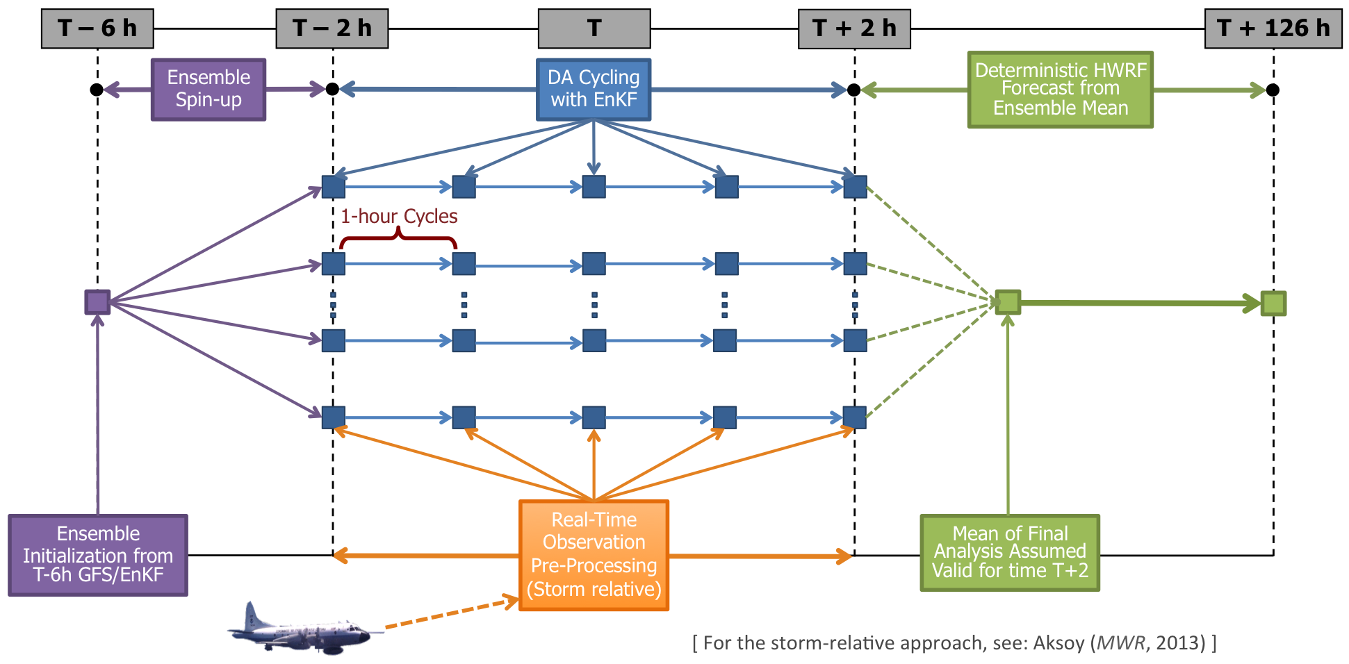
- The positive impact of aircraft observations for vortex-scale data assimilation has been demonstrated using a large sample of hurricane cases with aircraft data. These results are summarized in Aksoy et al. 2013.
- Since the 2012 hurricane season, a storm-relative observation processing capability is implemented. The details of this technique are discussed in Aksoy 2013. You can also find more information on the storm-relative data assimilation project page.
- During the 2013 hurricane season, satellite retrieved wind and thermodynamic observations were assimilated in addition to traditional aircraft-based observations. Some of the latest results from the 2013 runs are summarized in the the first half of a recent talk by Altug Aksoy. The following figure summarizes HEDAS' 2013 performance in terms of verifications of HWRF forecasts initialized with the HEDAS vortex:

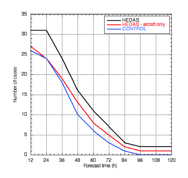
From the figure, it is clear that forecasts initialized with a HEDAS vortex analysis are improved in terms of both track and intensity when compared to the operational HWRF forecasts. Furthermore, the addition of satellite retrieval observations to our traditional aircraft dataset appears to make further improvements in intensity. Due to the limited number of cases verified especially at longer lead times, while these results by no means should be interpreted as comprehensive, it is nevertheless encouraging to see that advanced data assimilation techniques with high-quality observations do make a difference in TC forecasts. A further indication of forecast improvements can be also found in the following figure, which shows the number of cases verified for each forecast configuration tested:

The fact that the number of cases that can be verified increases as satellite data are assimilated in addition to aircraft data indicates that forecasts initialized with vortex analyses that assimilated satellite data are able to maintain the initial vortex for longer lead times than just aircraft data.
- Our recent results with satellite AMVs plus AIRS and GPS-RO retrieval observations were summarized in a poster that was recently presented at the American Meteorological Society's 31st Conference on Hurricanes and Tropical Meteorology in San Diego, California:

References:
- Aksoy, A., 2013: Vortex-Scale Data Assimilation with HEDAS in the 2013 Season and Impacts of Parameter Perturbations. Hurricane Forecast Improvement Project Biweekly Conference Call, December 2013, National Oceanic and Atmospheric Administration.
- Aksoy, A., S. D. Aberson, T. Vukicevic, K. J. Sellwood, S. Lorsolo, and X. Zhang, 2013: Assimilation of high-resolution tropical cyclone observations with an ensemble Kalman filter using NOAA/AOML/HRD's HEDAS: Evaluation of the 2008-2011 vortex-scale analyses. Monthly Weather Review, 141, 1842-1865.
- Aksoy, A., 2013: Storm-Relative Observations in Tropical Cyclone Data Assimilation with an Ensemble Kalman Filter. Monthly Weather Review, 141, 506-522.
- Vukicevic, T., A. Aksoy, P. Reasor, S. D. Aberson, K. J. Sellwood, and F. Marks, 2013: Joint impact of forecast tendency and state error biases in ensemble Kalman filter data assimilation of inner-core tropical cyclone observations. Monthly Weather Review, 141, 2992-3006.
- Rogers, R., S. Aberson, A. Aksoy, and Co-Authors, 2013: NOAA's Hurricane Intensity Forecasting Experiment (IFEX): A Progress Report. Bull. Amer. Meteor. Soc., 94, 859-882.
- Aksoy, A., S. Lorsolo, T. Vukicevic, K. J. Sellwood, S. D. Aberson, and F. Zhang, 2012: The HWRF Hurricane Ensemble Data Assimilation System (HEDAS) for high-resolution data: The impact of airborne Doppler radar observations in an OSSE. Monthly Weather Review, 140, 1843-1862.
- Ramos, N. A., 2012: Structure and evolution of developing and non-developing African Easterly Waves during National Aeronautics and Space Administration African Monsoon Multidisciplinary Analyses (NAMMA). Dissertation, Howard University, 195 pp.
Back to Main Projects Page
|
|


