Monthly Report Summary Information
The Monthly Report Summary Information is a synopsis of the collection of national and global summaries released each month.
National Summary Information - May 2012
See Full Report
U.S. experiences second warmest May, hottest spring on record
Lower 48 also experienced record warm year-to-date and twelve-month periods
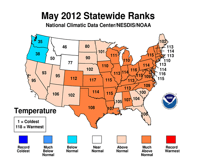
The average temperature for the contiguous U.S. during May was 64.3°F, 3.3°F above the long-term average, making it the second warmest May on record. The month's high temperatures also contributed to the warmest spring, warmest year-to-date, and warmest 12-month period the nation has experienced since recordkeeping began in 1895.
The spring season's (March-May) nationally-averaged temperature was 57.1°F, 5.2°F above the 1901-2000 long-term average, surpassing the previous warmest spring (1910) by 2.0°F.
Precipitation totals across the country were mixed during May, with the nation as a whole being drier than average. The nationally-averaged precipitation total of 2.51 inches was 0.36 inch below average. The coastal Southeast received some drought relief when Tropical Storm Beryl brought heavy rains to the region late in the month.
Note: The May/Spring Monthly Climate Report for the United States has several pages of supplemental information and data regarding some of the exceptional events from the month and season.

Significant climate events for May/Spring 2012. Click to enlarge, or click here for the National Overview.
U.S. climate highlights — May
- Warmer-than-average temperatures occurred across all parts of the contiguous U.S., except the Northwest, during May. Twenty-six states had May temperatures ranking among their ten warmest.
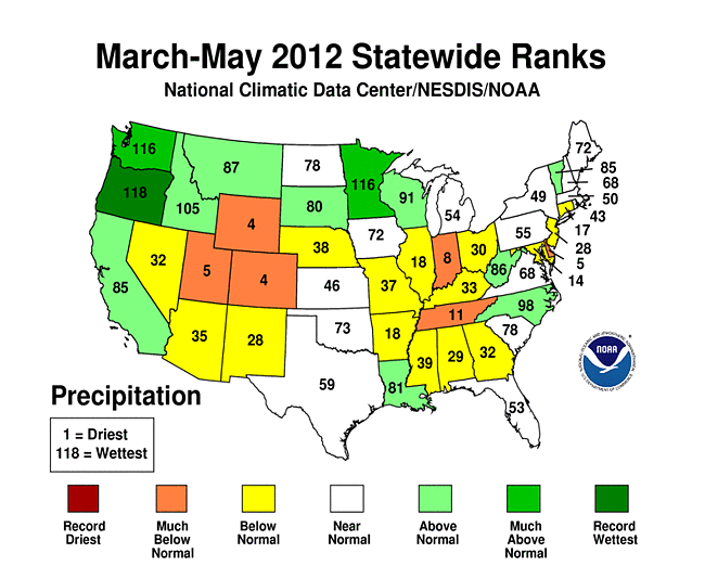
- Precipitation patterns across the contiguous U.S. were mixed during May. The Eastern Seaboard and Upper Midwest were wetter than average. North Carolina, South Carolina, Vermont, New Hampshire and Minnesota had May precipitation totals among their ten wettest. Dry conditions prevailed across the Mid-Mississippi River Valley, Southern Plains and the Interior West with Arkansas, Missouri, Kansas, Nevada and Utah having a top ten dry May.
- Tropical Storm Beryl made landfall near Jacksonville, Fla., on May 28, bringing beneficial rainfall to parts of the drought-stricken Southeast. Beryl occurred on the heels of Tropical Storm Alberto, which occurred offshore the Carolinas, marking the third time on record that two tropical cyclones reached tropical storm strength during May (prior to the start of June 1 hurricane season) in the North Atlantic basin. (click for a table of all known pre-season tropical cyclones in the North Atlantic)
- Ongoing drought, combined with windy conditions, created ideal wildfire conditions across the Southwest. The Whitewater-Baldy Fire complex in the Gila National Forest of western New Mexico charred over 210,000 acres by the beginning of June. It surpassed 2011's Las Conchas Fire as largest wildfire on record for the state.
- According to the U.S. Drought Monitor, as of May 29th, 37.4 percent of the contiguous U.S. experienced drought conditions, a slight decrease from 38.2 percent at the beginning of May. Drought conditions improved across the coastal Southeast, the Southern Plains, Northeast and Upper Midwest while they deteriorated for parts of the Mid-South and Southwest.
U.S. climate highlights — Spring (March-May)
- The nationally-averaged spring temperature of 57.1°F was 5.2°F above the long-term average. With the warmest March, third warmest April and second warmest May, Spring 2012 marked the largest temperature departure from average of any season on record for the contiguous United States.
- Spring was drier than average for the contiguous U.S. as a whole, with a national precipitation total of 7.47 inches, 0.24 inch below average.
- Record and near-record warmth dominated the eastern two-thirds of the nation during spring. Thirty-one states were record warm for the season and 11 additional states had spring temperatures ranking among their ten warmest. Only Oregon and Washington had spring temperatures near normal.
- Wetter-than-average conditions prevailed from the West Coast through the Northern Plains and into the Upper Midwest. Oregon was record wet and Minnesota and Washington were third wettest. The Intermountain West, Ohio Valley, and parts of the Mid-Atlantic were drier than average. Colorado, Utah, Wyoming, Indiana, and Delaware had a top ten dry spring.
- The U.S. Climate Extremes Index, an index that tracks the highest and lowest 10 percent of extremes in temperature, precipitation, drought and tropical cyclones across the contiguous U.S., was a record-large 44 percent during the March-May period, over twice the average value. Extremes in warm daytime temperatures (81 percent) and warm nighttime temperatures (72 percent) covered large areas of the nation, contributing to the record high value.
U.S. climate highlights — Year-to-date
- The January-May months were the warmest such period on record for the contiguous United States, with an average temperature of 49.2°F, 5.0°F above the long-term average. Twenty-nine states, all east of the Rockies, were record warm for the five-month period and an additional 14 states had temperatures for the period among their ten warmest.

Year-to-date average temperature (through May) for the 83 years on record at St. Louis, Missouri. 2012 in crimson. Please click for similar supplemental information for about 150 U.S. cities. - The year's first five months also brought dry conditions to much of the East. The Southwest was drier than average while wetter-than-average conditions persisted for the Pacific Northwest, Upper Midwest and the western Gulf Coast. The national precipitation total for the five-month period was nearly 1.0 inch below average.
12-month period (June 2011 - May 2012)
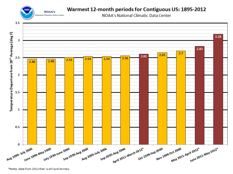
- The June 2011-May 2012 period was the warmest 12-month period of any 12 months on record for the contiguous United States. The nationally-averaged temperature of 56.0°F was 3.2°F above the long-term average, surpassing the previous warmest 12-month period, set last month, by 0.4°F. The 12-month period encapsulated the second warmest summer, fourth warmest winter, and the warmest spring on record. Every state across the contiguous U.S. had warmer than average temperatures for the period, except Washington, which was near normal.
- Each of the 12 months from June 2011 through May 2012 ranked among the warmest third of their historical distribution for the first time in the 1895-present record. The odds of this occurring randomly are 1 in 531,441.

The ten warmest 12-month periods of the U.S. record. Click to enlarge, or click here for expanded information.
 NOAA's National Centers for Environmental Information


