Monthly Report Summary Information
The Monthly Report Summary Information is a synopsis of the collection of national and global summaries released each month.
National Summary Information - July 2012
See Full Report
July 2012: hottest month on record for contiguous United States
Drought expands to cover nearly 63% of the Lower 48; wildfires consume 2 million acres
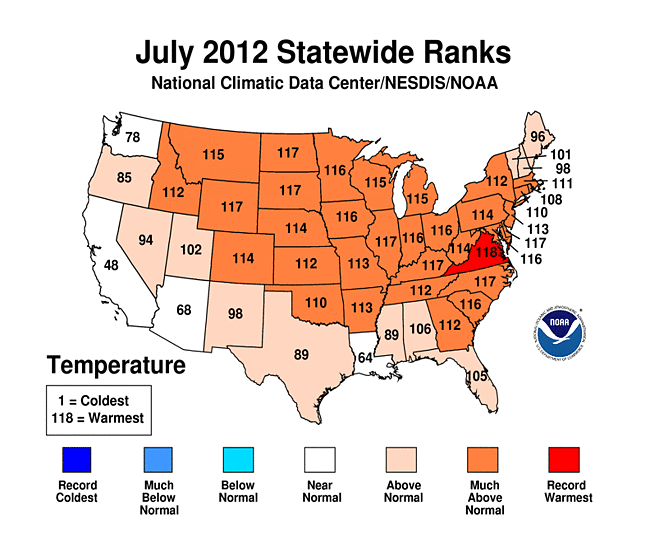
The average temperature for the contiguous U.S. during July was 77.6°F, 3.3°F above the 20th century average, marking the hottest July and the hottest month on record for the nation. The previous warmest July for the nation was July 1936 when the average U.S. temperature was 77.4°F. The warm July temperatures contributed to a record-warm first seven months of the year and the warmest 12-month period the nation has experienced since recordkeeping began in 1895.
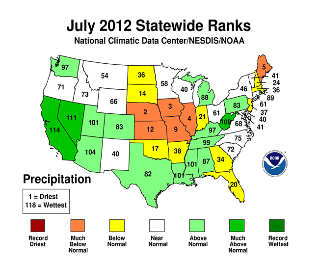
Precipitation totals were mixed during July, with the contiguous U.S. as a whole being drier than average. The nationally averaged precipitation total of 2.57 inches was 0.19 inch below average. Near-record dry conditions were present for the middle of the nation, with the drought footprint expanding to cover nearly 63 percent of the Lower 48, according the U.S. Drought Monitor.

Significant climate events for July 2012. Click to enlarge, or click here for the National Overview.
Note: The July Monthly Climate Report for the United States has several pages of supplemental information and data regarding some of the exceptional events from the month and season.
U.S. climate highlights: July
- Higher-than-average temperatures engulfed much of the contiguous U.S. during July, with the largest temperature departures from the 20th century average occurring across most of the Plains, the Midwest, and along the Eastern Seaboard. Virginia had its warmest July on record, with a statewide temperature 4.0°F above average. In total, 32 states had July temperatures among its ten warmest, with seven states having their second warmest July on record.
- Drier-than-average conditions continued across the Central Plains and Midwest during July. Nebraska, Iowa, Illinois, and Missouri had July precipitation totals ranking among their ten driest. Maine had its fifth driest July on record.
- An active storm pattern in the Southwest contributed to California having its fifth wettest July on record and Nevada having its eighth wettest. Wetter-than-average conditions were also observed through the rest of the Southwest, along the western Gulf Coast, and through the Ohio Valley where West Virginia had its tenth wettest July.
- The warm and dry conditions over a large portion of the country were associated with ideal wildfire conditions. Over 2 million acres were burned nationwide during July due to wildfires, nearly half a million acres above average, and the fourth most on record since 2000.
- A list of select July temperature and precipitation records can be found here.
Drought conditions update
- The May-July months, an important period for agriculture, was the second warmest and 12th driest such three-months for the Lower 48, contributing to rapid expansion of drought. The central regions of the country were hardest hit by the drought, where ten states had three-month precipitation totals among their ten driest, including Nebraska, Kansas, and Arkansas which were record dry.
- According to the July 31, 2012, U.S. Drought Monitor (USDM), 62.9 percent of the contiguous U.S. was experiencing moderate to exceptional drought at the end of July. This is an increase of about 6.9 percent compared to the end of June. The maximum value of 63.9 percent reached on July 24 is a record in the 13-year history of the USDM.
- The area of the country in the worst drought categories (extreme to exceptional drought) doubled from 10 percent last month to 22 percent this month. The extreme dryness and excessive heat devastated crops and livestock from the Great Plains to Midwest.
- The Primary Corn and Soybean Agricultural Belt, hard hit by drought, experienced its eighth driest July, third driest June-July, and sixth driest April-July (growing season) in the 1895-2012 record.
- According to the Palmer Drought Severity Index, whose record spans the 20th century, about 57 percent of the contiguous U.S. was experiencing moderate-to-extreme drought in July. The last drought this extensive was in December 1956 when about 58 percent of the nation was in moderate-to-extreme drought.
Year-to-date: January-July
- The January-July period was the warmest first seven months of any year on record for the contiguous United States. The national temperature of 56.4°F was 4.3°F above the long-term average. Most of the contiguous U.S. was record and near-record warm for the seven-month period, except the Pacific Northwest, which was near average.

Year-to-date temperature, by month, for 2012 (red), compared to the other 117 years on record for the contiguous U.S., with the five ultimately warmest years (orange) and five ultimately coolest years (blue) noted. The 2012 data are still preliminary. Please click for a more thorough explanation. - The first seven months of 2012 were drier than average, ranking as 15th driest January-July on record. Below-average precipitation totals were observed for a large portion of the country, with 12 states having January-July precipitation totals among their ten driest. Above-average precipitation was observed for the Upper Midwest and the Pacific Northwest.
- The U.S. Climate Extremes Index (USCEI), an index that tracks the highest and lowest 10 percent of extremes in temperature, precipitation, drought and tropical cyclones across the contiguous U.S., was a record-large 46 percent during the January-July period, over twice the average value, and surpassing the previous record large CEI of 42 percent which occurred in 1934. Extremes in warm daytime temperatures (83 percent) and warm nighttime temperatures (74 percent) both covered record large areas of the nation, contributing to the record high year-to-date USCEI value.
12-month period: August 2011-July 2012
- The August 2011-July 2012 period was the warmest 12-month period of any 12-months on record for the contiguous U.S., narrowly surpassing the record broken last month for the July 2011-June 2012 period by 0.07°F. The nationally averaged temperature of 56.1°F was 3.3°F above the long term average. Except Washington, which was near average, every state across the contiguous U.S. had warmer than average temperatures for the period.

The ten warmest 12-month periods of the U.S. record. Click to enlarge, or click here for expanded information.
 NOAA's National Centers for Environmental Information
